

View Information About HSR Ratings

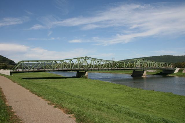
Although this is a large bridge, for a continuous truss bridge of its type, is quite small. It has the shape of a cantilever truss, with towers over the piers, but appears to lack hinges which would mean that it functions as a continuous truss. Small continuous through truss bridges are uncommon, and thus are an unusual case where a bridge is significant because it is small. The bridge is an excellent example of continuous truss design in the 1930s. Continuous through truss bridges were used in modest numbers for large river crossings starting around 1915. The Bridge Street Bridge is significant as an excellent example of this bridge type, as it retains excellent historic integrity. This bridge is also locally significant as one of the only continuous through truss bridges in western New York state.
This bridge is a magnificent and beautiful structure that is also in a beautiful setting, with gorgeous mountains rising up behind the structure. The relatively short towers form shallow curves on the bridge that are complimented by the shallow curves that accent the bottom of the portal and sway bracing, creating a visually pleasing structure. The bridge features built-up beams composing the members and chords of the truss, most of which feature v-lacing and lattice which add greatly to the geometric beauty of the bridge. It is truly a priceless treasure for the city of Corning. Fortunately, the city of Corning, who owns the bridge, appears to agree that this structure is not only beautiful, but can continue to be a functional vehicular crossing if properly maintain. The bridge was rehabilitated in 1999, and today continues to remain in excellent condition, with a "Good" superstructure rating and a 92.5% sufficiency rating... an excellent rating that is nearly unheard of with historic bridges! The city of Corning should consider erecting some interpretive signage near the bridge explaining the bridge's design and significance.
![]()
![]()
Coordinates (Latitude, Longitude):
Search For Additional Bridge Listings:
Bridgehunter.com: View listed bridges within 0.5 miles (0.8 kilometers) of this bridge.
Bridgehunter.com: View listed bridges within 10 miles (16 kilometers) of this bridge.
Additional Maps:
Google Streetview (If Available)
GeoHack (Additional Links and Coordinates)
Apple Maps (Via DuckDuckGo Search)
Apple Maps (Apple devices only)
Android: Open Location In Your Map or GPS App
Flickr Gallery (Find Nearby Photos)
Wikimedia Commons (Find Nearby Photos)
Directions Via Sygic For Android
Directions Via Sygic For iOS and Android Dolphin Browser
USGS National Map (United States Only)
Historical USGS Topo Maps (United States Only)
Historic Aerials (United States Only)
CalTopo Maps (United States Only)

© Copyright 2003-2025, HistoricBridges.org. All Rights Reserved. Disclaimer: HistoricBridges.org is a volunteer group of private citizens. HistoricBridges.org is NOT a government agency, does not represent or work with any governmental agencies, nor is it in any way associated with any government agency or any non-profit organization. While we strive for accuracy in our factual content, HistoricBridges.org offers no guarantee of accuracy. Information is provided "as is" without warranty of any kind, either expressed or implied. Information could include technical inaccuracies or errors of omission. Opinions and commentary are the opinions of the respective HistoricBridges.org member who made them and do not necessarily represent the views of anyone else, including any outside photographers whose images may appear on the page in which the commentary appears. HistoricBridges.org does not bear any responsibility for any consequences resulting from the use of this or any other HistoricBridges.org information. Owners and users of bridges have the responsibility of correctly following all applicable laws, rules, and regulations, regardless of any HistoricBridges.org information.
![]()