We Recommend:
Bach Steel - Experts at historic truss bridge restoration.
Glen Brook Bridge

Primary Photographer(s): Marc Scotti
Bridge Documented: December 26, 2011 - 2018
Hammondsport: Steuben County, New York: United States
By Builder/Contractor: Groton Bridge Company of Groton, New York
Not Available or Not Applicable
24.0 Feet (7.3 Meters)
24.0 Feet (7.3 Meters)
Not Available
1 Main Span(s)
Not Applicable

View Information About HSR Ratings
Bridge Documentation
This bridge no longer exists!
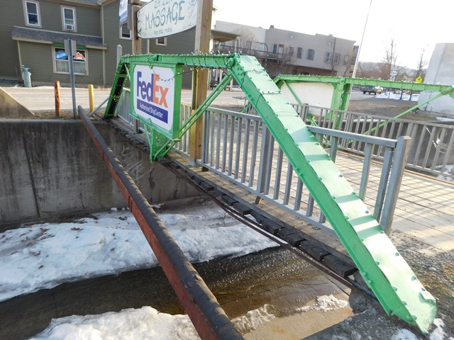
Bridge Status: This historic bridge was demolished and replaced!This nice little two panel pin-connected truss bridge was demolished and replaced even though the trusses were functioning as decorations only. It was replaced with a slab of concrete. The nearby Over The Bridge Wine Bar will now have to change the truss logo on its sign to a horizontal line and change its name to "Over the Slab Wine." Or perhaps "Driven To Drink" might be a good rename given that is what will happen to anyone visiting the area hoping to see this historic bridge! It is unclear why the bridge trusses were not retained and placed on the replacement bridge as decorations. In its form seen in these photos, the trusses were not functioning and were decorative only. They lacked u-bolts and a floorbeam. Instead a series of extremely shallow i-beams carried loads.
The local Images of America volume shows a picture of what is likely this bridge on a dirt road, with the common Groton semi-circle plaques still intact on top.
Also included in the photo gallery is something that may be of interest to bridge enthusiasts. Nearby in this same town is the Glenn H Curtiss Museum, which has a caboose on its property. Inside this caboose are several bridge plaques from unknown locations.
The estimated bridge length given would make this one of the shortest pony trusses documented on HistoricBridges.org.
This bridge is tagged with the following special condition(s): Trusses Converted To Decorative and Unorganized Photos
![]()
Photo Galleries and Videos: Glen Brook Bridge
Unorganized Photos
Original / Full Size PhotosA collection of overview and detail photos, presented as an unorganized and unlabeled collage and gallery. This gallery offers photos in the highest available resolution and file size in a touch-friendly popup viewer.
Alternatively, Browse Without Using Viewer
![]()
Unorganized Photos
Mobile Optimized PhotosA collection of overview and detail photos, presented as an unorganized and unlabeled collage and gallery. This gallery features data-friendly, fast-loading photos in a touch-friendly popup viewer.
Alternatively, Browse Without Using Viewer
![]()
Maps and Links: Glen Brook Bridge
This historic bridge has been demolished. This map is shown for reference purposes only.
Coordinates (Latitude, Longitude):
Search For Additional Bridge Listings:
Bridgehunter.com: View listed bridges within 0.5 miles (0.8 kilometers) of this bridge.
Bridgehunter.com: View listed bridges within 10 miles (16 kilometers) of this bridge.
Additional Maps:
Google Streetview (If Available)
GeoHack (Additional Links and Coordinates)
Apple Maps (Via DuckDuckGo Search)
Apple Maps (Apple devices only)
Android: Open Location In Your Map or GPS App
Flickr Gallery (Find Nearby Photos)
Wikimedia Commons (Find Nearby Photos)
Directions Via Sygic For Android
Directions Via Sygic For iOS and Android Dolphin Browser
USGS National Map (United States Only)
Historical USGS Topo Maps (United States Only)
Historic Aerials (United States Only)
CalTopo Maps (United States Only)

