

View Information About HSR Ratings
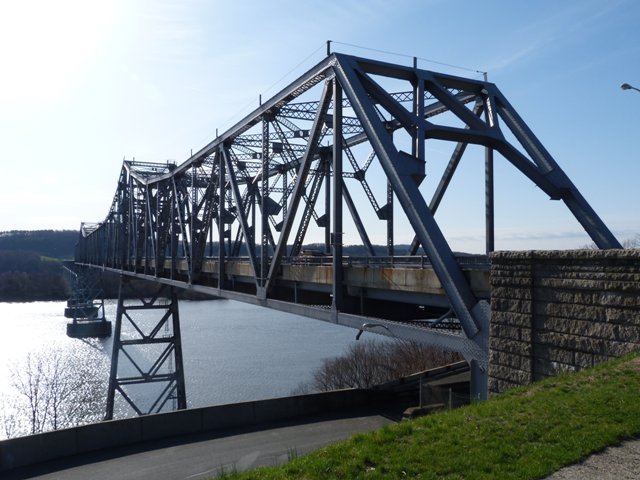
This is a monumental size cantilever truss bridge that is operated as a toll bridge by a state agency. Likely aided by funds generated by tolls, the bridge appears to be in excellent condition. The main span is a through truss cantilever bridge of overall traditional composition. However, the massive a-frame portal bracing and the heavy built-up steel bents are distinctive details that give the bridge a unique appearance.
In addition, the bridge's long series of deck cantilever approach spans add to the bridge's unique appearance. The bridge's cantilever deck truss approach spans appear to be designed so that every other span contains a suspended span with cantilever arms, and the spans between those consisting of two anchor arms. This assumption is made based on aerial imagery that shows expansion joints on the deck of every other span where the ends of a suspended span would be expected. The visual appearance of these approach spans is such that the truss appearance to casual viewers is identical from span to span.
Due to time constraints on the part of HistoricBridges.org, and also the fact that the best location to photograph the bridge... an access road that runs under the bridge at the western end... was posted as closed to the public... only a few photos of this bridge are currently available. It is HistoricBridges.org's strong opinion that restricting access to this road that runs under the bridge is terribly insensitive. The reality is that there should be a small "scenic outlook" available to the public at this location, where the beautiful bridge and river can be safely and conveniently appreciated by the public. As a toll bridge that benefits from people actually using the bridge, such a facility could only stand to help bring in increased revenue for the bridge.
The engineer for this bridge, Glenn B. Woodruff, reportedly worked on the Oakland Bay Bridge in California after this bridge.
![]()
![]()
![]()

![]()
Coordinates (Latitude, Longitude):
Search For Additional Bridge Listings:
Bridgehunter.com: View listed bridges within 0.5 miles (0.8 kilometers) of this bridge.
Bridgehunter.com: View listed bridges within 10 miles (16 kilometers) of this bridge.
Additional Maps:
Google Streetview (If Available)
GeoHack (Additional Links and Coordinates)
Apple Maps (Via DuckDuckGo Search)
Apple Maps (Apple devices only)
Android: Open Location In Your Map or GPS App
Flickr Gallery (Find Nearby Photos)
Wikimedia Commons (Find Nearby Photos)
Directions Via Sygic For Android
Directions Via Sygic For iOS and Android Dolphin Browser
USGS National Map (United States Only)
Historical USGS Topo Maps (United States Only)
Historic Aerials (United States Only)
CalTopo Maps (United States Only)

© Copyright 2003-2024, HistoricBridges.org. All Rights Reserved. Disclaimer: HistoricBridges.org is a volunteer group of private citizens. HistoricBridges.org is NOT a government agency, does not represent or work with any governmental agencies, nor is it in any way associated with any government agency or any non-profit organization. While we strive for accuracy in our factual content, HistoricBridges.org offers no guarantee of accuracy. Information is provided "as is" without warranty of any kind, either expressed or implied. Information could include technical inaccuracies or errors of omission. Opinions and commentary are the opinions of the respective HistoricBridges.org member who made them and do not necessarily represent the views of anyone else, including any outside photographers whose images may appear on the page in which the commentary appears. HistoricBridges.org does not bear any responsibility for any consequences resulting from the use of this or any other HistoricBridges.org information. Owners and users of bridges have the responsibility of correctly following all applicable laws, rules, and regulations, regardless of any HistoricBridges.org information.
![]()