We Recommend:
Bach Steel - Experts at historic truss bridge restoration.
Verrazzano-Narrows Bridge
Verrazano-Narrows Bridge

Primary Photographer(s): Nathan Holth
Bridge Documented: October 19, 2013 and September 4, 2019
I-278 (Staten Island Expressway and Brooklyn - Queens Expressway) Over The Narrows
New York: Brooklyn, New York and Staten Island, New York: United States
Metal Deck Truss Stiffening Wire Cable Suspension, Fixed and Approach Spans: Metal Deck Girder, Fixed
1961 By Builder/Contractor: American Bridge Company of New York, New York and Engineer/Design: Othmar Ammann
Not Available or Not Applicable
4,260.0 Feet (1298.4 Meters)
7,934.0 Feet (2418.3 Meters)
73.8 Feet (22.49 Meters)
3 Main Span(s) and 6 Approach Span(s)
5521218

View Information About HSR Ratings
Bridge Documentation
View Archived National Bridge Inventory Report - Has Additional Details and Evaluation
View A Historical Article About This Bridge From Popular Science
View An Archived Wikipedia Article About This Bridge In PDF Format

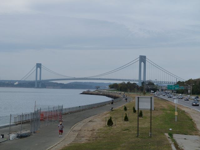
This enormous bridge had the longest suspension bridge span in the world when completed, knocking off the long-held record of the Golden Gate Bridge. It is so large that it looms over the surrounding landscape and is visible from many locations.
The bridge was designed by famous engineer Othmar Ammann. Like the other suspension bridges he designed in the New York City area, this bridge has towers with a relatively simple and plain appearance. They are composed of two main posts that are connected at the top with a solid section of bracing that features an arched design at the bottom. This basic tower design is shared among all the Ammann suspension bridges, and seems to indicate that Ammann felt that a simple, streamlined bridge was the optimal aesthetic. His approach to aesthetics give his bridges to appearance of being newer than they really are. Compare this to the greater quantity and visual complexity of the bracing between the tower posts of the Mackinac Bridge, designed by another famed engineer, David Steinman.
The bridge is a double-deck design, and the lower deck is contained within the Warren truss stiffening.
HistoricBridges.org strictly speaking does not have a full photo-documentation of this bridge. What is available is a ton of photos taken from the upper deck of the bridge as well as a few distant overview photos. This bridge was crossed a couple times during a visit to the New York City area. Time did not allow for a full photo-documentation, but photos were taken (including some excellent wide angle photos with a GoPro Camera) while driving over the bridge. A round trip over the bridge costs a staggering $15 so it makes sense to get your money's worth by taking lots of photos.
Additional information is available here.
This bridge is tagged with the following special condition(s): Unorganized Photos
![]()
Photo Galleries and Videos: Verrazzano-Narrows Bridge
Bridge Photo-Documentation
Original / Full Size PhotosA collection of overview and detail photos. This gallery offers photos in the highest available resolution and file size in a touch-friendly popup viewer.
Alternatively, Browse Without Using Viewer
![]()
Bridge Photo-Documentation
Mobile Optimized PhotosA collection of overview and detail photos. This gallery features data-friendly, fast-loading photos in a touch-friendly popup viewer.
Alternatively, Browse Without Using Viewer
![]()
Additional Unorganized Photos
Original / Full Size PhotosA supplemental collection of photos that are from additional visit(s) to the bridge and have not been organized or captioned. This gallery offers photos in the highest available resolution and file size in a touch-friendly popup viewer.
Alternatively, Browse Without Using Viewer
![]()
Additional Unorganized Photos
Mobile Optimized PhotosA supplemental collection of photos that are from additional visit(s) to the bridge and have not been organized or captioned. This gallery features data-friendly, fast-loading photos in a touch-friendly popup viewer.
Alternatively, Browse Without Using Viewer
![]()
Maps and Links: Verrazzano-Narrows Bridge
Coordinates (Latitude, Longitude):
Search For Additional Bridge Listings:
Bridgehunter.com: View listed bridges within 0.5 miles (0.8 kilometers) of this bridge.
Bridgehunter.com: View listed bridges within 10 miles (16 kilometers) of this bridge.
Additional Maps:
Google Streetview (If Available)
GeoHack (Additional Links and Coordinates)
Apple Maps (Via DuckDuckGo Search)
Apple Maps (Apple devices only)
Android: Open Location In Your Map or GPS App
Flickr Gallery (Find Nearby Photos)
Wikimedia Commons (Find Nearby Photos)
Directions Via Sygic For Android
Directions Via Sygic For iOS and Android Dolphin Browser
USGS National Map (United States Only)
Historical USGS Topo Maps (United States Only)
Historic Aerials (United States Only)
CalTopo Maps (United States Only)


