HistoricBridges.org Menu: HistoricBridges.org Menu:


We Recommend:
Bach Steel - Experts at historic truss bridge restoration.

HistoricBridges.org: Bridge Browser

Inner Belt Bridge

Central Viaduct

Inner Belt Bridge

Primary Photographer(s): Nathan Holth

Bridge Documented: June 24, 2007 and July 7, 2014

View Photos
and Videos
View Maps
and Links

Facility Carried / Feature Intersected
I-90 Over Cuyahoga River
Location
Cleveland: Cuyahoga County, Ohio: United States
Structure Type
Metal Cantilever 16 Panel Rivet-Connected Pratt Deck Truss, Fixed and Approach Spans: Metal Stringer (Multi-Beam), Fixed
Construction Date and Builder / Engineer
1959 By Builder/Contractor: Fort Pitt Bridge Works of Pittsburgh, Pennsylvania
Rehabilitation Date
Not Available or Not Applicable
Main Span Length
400.0 Feet (121.9 Meters)
Structure Length
5,078.0 Feet (1547.8 Meters)
Roadway Width
110 Feet (33.53 Meters)
Spans
9 Main Span(s) and 33 Approach Span(s)
Inventory Number
1809393

Historic Significance Rating (HSR)
View Information About HSR Ratings

Bridge Documentation

This bridge no longer exists!

View Archived National Bridge Inventory Report - Has Additional Details and Evaluation

View Historical Article About This Bridge

View Original Site Plans For This Bridge

View Original Shop Drawings For This Bridge (Large File)

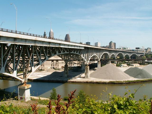
This bridge has held the record of being the widest bridge in Ohio. Although one of the youngest historic bridges in Cleveland, the structure is a very impressive structure that is worthy of preservation. The bridge features multiple deck cantilever truss spans of varying size. The bridge also features a pleasing curve that adds to the aesthetic value of the bridge.

ODOT conducted a study to determine how to improve I-90. Among the alternatives, demolition of this historic bridge was considered and quickly chosen. It didn't help that a committee in 2004 decided that the bridge would be not eligible for the National Register of Historic Places despite its long length and complex design. You barely need to read between the lines of the Historic Bridge Inventory information below and it is obvious that the bridge SHOULD have been considered eligible for the National Register of Historic Places under Criterion C (engineering significance) and possible Criterion A (significant events) as well since it was a complex bridge covered in engineering literature and was a critical part of a major and influential travel corridor. The committee that found the bridge "not eligible" in 2004 seems like a poorly veiled attempt (but successful) to bypass Section 106 and other federal laws that attempt to protect historic bridges.

People interested in this project had been fighting to get a non-motorized path integrated into a new Inner Belt Bridge. One novel option that could have been considered, along with rehabilitating the bridge for continued vehicular use is to add a cantilevered walkway below the main deck of the historic bridge, beside the trusses of the structure. This solution would allow pedestrians to view the trusses of the bridge, and also separate them from high-speed interstate traffic. These are the types of creative ideas that can enhance a city and also extend the usefulness of a historic bridge.

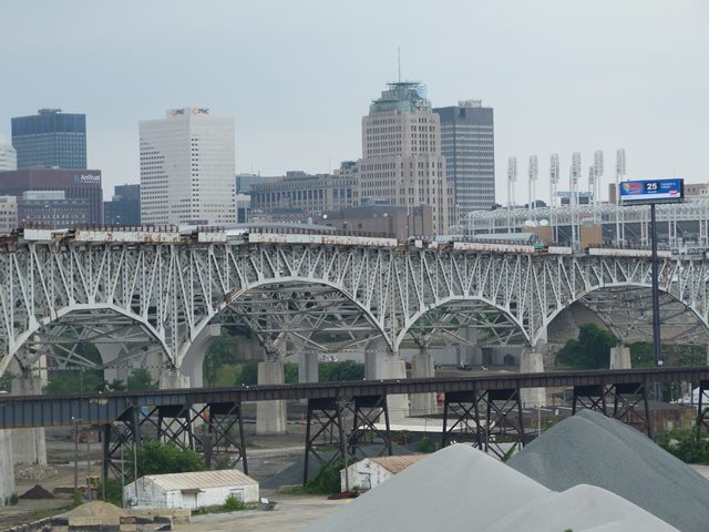
Information and Findings From Ohio's Historic Bridge Inventory

Setting/Context

The high level viaduct, which is part of the inner belt freeway south of downtown Cleveland, carries 8 lanes of traffic over the Cuyahoga River and its valley with a dock area, two major highways, a railroad freight yard, tracks of four different railroads, a sand and gravel processing plant, and several other industrial installations. The viaduct includes ramps that access Abbey Avenue on the west end and Ontario Avenue, E. 9 Street, and Carnegie Avenue on the east end.

Physical Description

The main spans of the 42-span, 5,077'-long viaduct are continuous cantilever deck trusses with some innovative details. The 1,204' of 14 spans of riveted, built-up girder-floorbeam or stringer approach spans for the west approach and 1,153' in 10 spans on the east. There are also two access ramps on the east end. Because of existing conditions on the east side, high-strength steel stringer spans rather than built up girder-floorbeam spans were used in order to achieve the needed span lengths and vertical clearances (many of the obstacles have since been removed). The continuous-cantilevered deck truss main spans are 2,721' long. The 7 truss spans with suspended sections vary in length from 226' to 400', and the truss lines are placed 90' apart. Transverse trusses spaced at 25' intervals are the same depth of the main trusses, and they serve as both floorbeams and sway frames. Truss members are built up box sections. The stringers supporting the deck are continuous over the sway frames and provide expansion at a maximum of 125' intervals. This was done to save steel. At the transition between the deep truss spans and the much shallower girder-floorbeam spans, two huge, 111'-long, built-up box section girders and "universal joints" that permit rotation in all directions and expansion in two directions are used. The box girders act like cap beams on the reinforced concrete columns, and they compensate for the difference in depth between the trusses and the girder approach spans. Throughout the truss spans, expansion, rotation, and wind shear are accommodated conventionally with shoes. The entire viaduct is finished with three rail high extruded pipe railings that was an ODOT standard of the period. The bridge deck and component members have been rehabilitated/strengthened in order to keep the viaduct in service, but these are minor alterations, including the replacement of rivets with high-strength bolts. The Abbey Avenue approach has also been improved.

There is an innovative linkage system between the cantilevered and suspended sections in some trusses. The weight of the suspended span is transferred to the cantilevers through heavy links that permit both expansion and rotation. Each link is an approximately 1' wide and 7' long eye bar and a 10 1/2"-diameter pin. The upper pin connects the linkage to the end vertical member of the suspended span while the lower pin connects to the bottom chord of the cantilever, and this transfers the loads of the suspended span to the cantilevers through the links.

Summary of Significance

The historic bridge committee (ODOT, FHWA, Ohio SHPO) agreed that the bridge be categorized as not eligible in June 2004.

The 1954-1959 Inner Belt Viaduct, the largest single pre-1961 construction contract ever awarded by the Ohio Department of Highways, embodies the genesis of urban expressways in this county, starting in the late 1930s when federal policy was changed to permit federal funding of urban highway projects, through World War II expressway planning, and culminating with its timely completion because of the 90%-10% federal/state interstate highway construction funding formula put in place with the passage of the 1956 highway federal-aid act. As the most ambitious highway bridge of the post-World War II and early interstate highway eras in Ohio, the Inner Belt Viaduct stands out from all the other 1950s highway projects as the most significant summation and manifestation of how the state and local governments were attempting to solve urban congestion and through traffic issues for over two decades. Its nearly 20-year history from conception to completion chronicles more clearly than any other bridge or section of highway in the state the evolution of "federalism" and highway planning and design. Given its sheer size and constraints imposed by local conditions, there are several unusual details like its "universal joint" bearings and suspended span connections that make it technologically significant. Its design and construction was followed in period technical literature.

The Inner Belt was conceived in 1940 as a means to reduce downtown traffic congestion, and its actual planning began in 1941-1944. It was to be part of the master plan of freeways through and around Cleveland that was developed by the city, county, and state during World War II. The plan designated downtown Cleveland as the hub with a series of freeway spokes radiating from it. Concentrically rimming that network of radial freeways would be a 3.2-mile long inner belt from E. 30th Street-Shoreway area on the east side to Abbey Avenue and W. 14th Street on the near west side. There would also be a central interchange in downtown Cleveland permitting easy access to all of the freeways. The report identified the Inner Belt as the first priority for a new project. The 1941-1944 expressway master plan came out of an important early study of Cleveland vehicular traffic undertaken by the federal Bureau of Public Roads in 1928. That report ranks as one of the earliest comprehensive highway planning studies ever undertaken in this country, and it recommended several dualized expressways, including beltways.

The expensive property acquisition for the Inner Belt alignment was started by the city about 1950, but progress was slow because matching federal funds were provided on a 50-50 formula. Noted consulting engineers Howard, Needles, Tammen, and Bergendoff were hired by the city in the fall of 1953 to design the viaduct, and construction began at the end of 1954. The abutments and piers were completed using the pre-1956, 50-50 funds, but completion of the extremely expensive superstructure and related sections of highway would have been considerably slower without the massive infusion of cash available to the states after passage of the Federal-Aid Highway Bill of 1956. That bill created the National System of Interstate and Defense Highways. The Inner Belt work qualified for 90% federal participation for interstate highway construction, and a May 5,1959, article in the Cleveland Plain-Dealer summed up what the 1956 legislation meant to this project. "Without this lions' share of money from Washington, much of the belt would have remained a paper freeway for years to come." With its 37 ramps (20 entrance and 17 exit), the Inner Belt cost approximately $25 million a mile compared with the Ohio Turnpike, under construction at the same time, that cost $1 million a mile. The Central Viaduct alone cost $18 million.

The Central Viaduct facilitated completion in 1962 of the Central Interchange in downtown Cleveland, and it stands basically as constructed and is the crown jewel of Cleveland's ambitious freeway network and the state's early (non-toll) interstate highways, both from the technological and the historical perspectives.

Bridge Considered Historic By Survey: Bridge Found Ineligible By "Historic Bridge Committee" in 2004


This bridge is tagged with the following special condition(s): Unorganized Photos

Divider

Photo Galleries and Videos: Inner Belt Bridge


View Photo Gallery

2007 Bridge Photo-Documentation

A collection of overview and detail photos. This photo gallery contains a combination of Original Size photos and Mobile Optimized photos in a touch-friendly popup viewer.
Alternatively, Browse Without Using Viewer

Divider

View Photo Gallery

2014 Additional Unorganized Photos

Original / Full Size Photos
Taken as demolition had begun, a supplemental collection of photos that are from additional visit(s) to the bridge and have not been organized or captioned. This gallery offers photos in the highest available resolution and file size in a touch-friendly popup viewer.
Alternatively, Browse Without Using Viewer

Divider

View Photo Gallery

2014 Additional Unorganized Photos

Mobile Optimized Photos
Taken as demolition had begun, a supplemental collection of photos that are from additional visit(s) to the bridge and have not been organized or captioned. This gallery features data-friendly, fast-loading photos in a touch-friendly popup viewer.
Alternatively, Browse Without Using Viewer

Divider

Maps and Links: Inner Belt Bridge

This historic bridge has been demolished. This map is shown for reference purposes only.

Coordinates (Latitude, Longitude):

Search For Additional Bridge Listings:

Bridgehunter.com: View listed bridges within 0.5 miles (0.8 kilometers) of this bridge.

Bridgehunter.com: View listed bridges within 10 miles (16 kilometers) of this bridge.

HistoricBridges.org Bridge Browser: View listed bridges within 0.5 miles (0.8 kilometers) of this bridge.

HistoricBridges.org Bridge Browser: View listed bridges within 10 miles (16 kilometers) of this bridge.

2021 National Bridge Inventory: View listed bridges within 0.5 miles (0.8 kilometers) of this bridge.

Additional Maps:

Google Maps

Google Streetview (If Available)

Bing Maps

OpenStreetMap

GeoHack (Additional Links and Coordinates)

Apple Maps (Via DuckDuckGo Search)

Apple Maps (Apple devices only)

MapQuest

HERE We Go Maps

ACME Mapper

Waze Map

Android: Open Location In Your Map or GPS App

Flickr Gallery (Find Nearby Photos)

Wikimedia Commons (Find Nearby Photos)

Directions Via Sygic For Android

Directions Via Sygic For iOS and Android Dolphin Browser

USGS National Map (United States Only)

Historical USGS Topo Maps (United States Only)

Historic Aerials (United States Only)

CalTopo Maps (United States Only)


Divider
 
Home Top

Divider

About - Contact

© Copyright 2003-2024, HistoricBridges.org. All Rights Reserved. Disclaimer: HistoricBridges.org is a volunteer group of private citizens. HistoricBridges.org is NOT a government agency, does not represent or work with any governmental agencies, nor is it in any way associated with any government agency or any non-profit organization. While we strive for accuracy in our factual content, HistoricBridges.org offers no guarantee of accuracy. Information is provided "as is" without warranty of any kind, either expressed or implied. Information could include technical inaccuracies or errors of omission. Opinions and commentary are the opinions of the respective HistoricBridges.org member who made them and do not necessarily represent the views of anyone else, including any outside photographers whose images may appear on the page in which the commentary appears. HistoricBridges.org does not bear any responsibility for any consequences resulting from the use of this or any other HistoricBridges.org information. Owners and users of bridges have the responsibility of correctly following all applicable laws, rules, and regulations, regardless of any HistoricBridges.org information.

Admin Login

Divider