

View Information About HSR Ratings
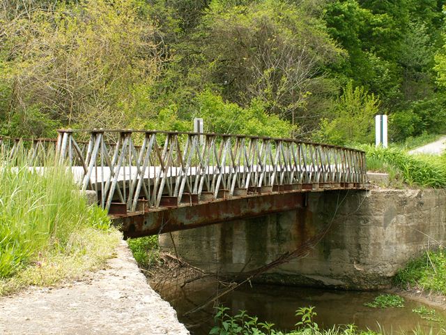
This bridge was assumed to have been built ca. 1875. It is impossible to fully understand the beauty and significance behind this bridge without knowing its true history. The bridge is a pony truss bridge with extremely shallow trusses composed of a network of pipes arranged in a Howe truss configuration. These pipes are held together with cast iron connection assemblies between plates that act as top and bottom chords. Each of these facts about the bridge is unusual for a metal truss in its own way, and together they form something very rare. This bridge is a truss bridge built to a patent by Joseph Davenport, who formed the prolific Massillon Bridge Company of Massillon, Ohio. The concept behind truss design used in this bridges was used by the Massillon Bridge Company in other ways, such as forming the top chord of its bowstring trusses, and sometimes to form other built-up parts of their trusses such as portal bracing. Visit the Fremont Mill Bridge page for more information. This bridge is critical in documenting the development of the metal truss bridge in Ohio, as well as the development of one of the most prolific 19th Century bridge builders in America.
A very small, and innocent looking bridge, the inexperienced bridge enthusiast might turn their nose up at this bridge. A closer look at the rivets as well as the extremely small i-beams under the bridge that compose the floor beams and deck beams testify to the age of the bridge. Preble County at one time must have realized the importance of this bridge, because rather than demolish it, they put large steel beams under the bridge to take over the load-bearing job. However, in 2011, photos on the Preble County Engineering website showed that this extremely rare historic bridge has now been replaced.
At the very least, the extremely rare Howe trusses of this bridge should have been carefully removed and placed into storage for future restoration and reuse at a new location, even if that reuse was to create a non-functional exhibit. However, the county simply sent these trusses to the scrap yard. How hard could it have been to save these very small trusses? The county claimed the trusses were beyond repair, but this statement is directly contradicted by the Historic Bridge Management Plan for this bridge. The Historic Bridge Management Plan stated that not only was preservation feasible, but it should be given high priority given the significance of the bridge. Apparently, Preble County was too busy planning to demolish a riveted truss bridge and replace it with a non-historic, modern covered bridge to be bothered with preserving an actual, genuine historic bridge that actually had real heritage value. The bridge was one of only two in Ohio.
Information and Findings From Ohio's Historic Bridge InventorySetting/Context The bridge carries a 2 lane road over a stream in a rural area of active farms. There is a modern house beyond the SE quadrant. The other quadrants are fields or woods. Physical Description The 1 span, 44'-long, pony truss bridge consists of an iron Howe pony truss, dated ca. 1873, that has been underpinned by two steel girders, ca. 1960. Although no longer functioning as originally intended, the trusses and floorbeams of the pony truss are intact although there is significant damage to several members from impact. The truss lines, the most significant features, are two shallow Howe trusses with wrought-iron plate chords. The diagonals are wrought-iron tubes that are compression fitting in cast-iron connecting pieces. The verticals are a pair of long bolts extending from the top chord to the bottom chord with the threaded ends and nuts at the bottom chord connection. The rolled I-beam floorbeams, which are offset from the panel points, rest directly on the bottom chord plate with a U-shaped clamp. The steel stringers and wood plank deck are not original. Integrity Underpinned with steel girders, ca. 1960. The truss lines have impact damage, including several bent and failed members at the east end of the bridge. Summary of Significance The bridge is a technologically significant, ca. 1873, wrought and cast-iron, Howe pony truss based on the design of Joseph Davenport of Massillon, OH. Although it has some loss of fabric from impact damage, the truss retains sufficient integrity of design and materials to convey its significance. Davenport's innovative design was one of the successful designs that helped to launch the important Ohio metal-truss bridge industry in the mid-19th-century. This particular design is derived from an all-metal Howe truss design that Davenport is known to have first developed in the late 1850s, and then refined and successfully marketed through the Massillon Bridge Co. and the Russell Bridge Co. (also of Massillon) from the 1860s to 1870s. Through innovative and often proprietary designs, marketed to local officials, companies such as these proved the worth of metal-truss technology to the improvement of the nation's roads. For more information on this truss design, see HAER OH-82, which records a similar bridge that once existed on Sockman Road in Knox County. There are at least six other known surviving examples of Davenport-associated Howe trusses in the inventory (Phase 1A, 2008). Justification The bridge is one of 6 extant examples dating from 1859 through the early 1870s of Joseph Davenport's technologically significant, innovative all-iron design that helped to launch Ohio's postbellum metal-truss bridge industry. All examples are rare and of exceptional importance because of their contribution to the evolution of the bridge type. Each is worthy of extraordinary measures to preserve and has high significance. Bridge Considered Historic By Survey: Yes |
![]()
![]()
![]()
This historic bridge has been demolished. This map is shown for reference purposes only.
Coordinates (Latitude, Longitude):
Search For Additional Bridge Listings:
Bridgehunter.com: View listed bridges within 0.5 miles (0.8 kilometers) of this bridge.
Bridgehunter.com: View listed bridges within 10 miles (16 kilometers) of this bridge.
Additional Maps:
Google Streetview (If Available)
GeoHack (Additional Links and Coordinates)
Apple Maps (Via DuckDuckGo Search)
Apple Maps (Apple devices only)
Android: Open Location In Your Map or GPS App
Flickr Gallery (Find Nearby Photos)
Wikimedia Commons (Find Nearby Photos)
Directions Via Sygic For Android
Directions Via Sygic For iOS and Android Dolphin Browser
USGS National Map (United States Only)
Historical USGS Topo Maps (United States Only)
Historic Aerials (United States Only)
CalTopo Maps (United States Only)

© Copyright 2003-2026, HistoricBridges.org. All Rights Reserved. Disclaimer: HistoricBridges.org is a volunteer group of private citizens. HistoricBridges.org is NOT a government agency, does not represent or work with any governmental agencies, nor is it in any way associated with any government agency or any non-profit organization. While we strive for accuracy in our factual content, HistoricBridges.org offers no guarantee of accuracy. Information is provided "as is" without warranty of any kind, either expressed or implied. Information could include technical inaccuracies or errors of omission. Opinions and commentary are the opinions of the respective HistoricBridges.org member who made them and do not necessarily represent the views of anyone else, including any outside photographers whose images may appear on the page in which the commentary appears. HistoricBridges.org does not bear any responsibility for any consequences resulting from the use of this or any other HistoricBridges.org information. Owners and users of bridges have the responsibility of correctly following all applicable laws, rules, and regulations, regardless of any HistoricBridges.org information.
![]()