

View Information About HSR Ratings
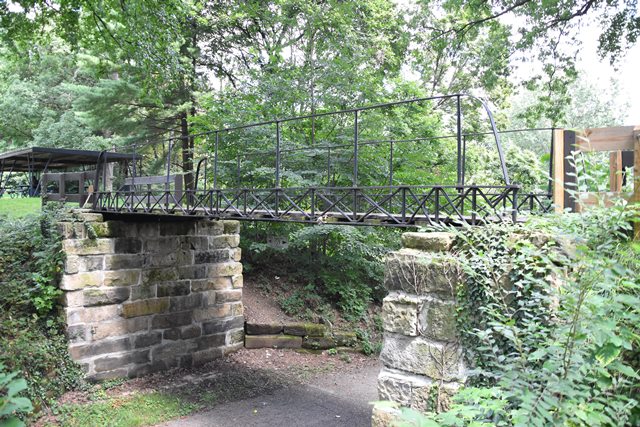
Designed by Joseph Davenport, who later formed the Massillon Bridge Company, this is the oldest surviving iron bridge in Ohio. It was the first iron bridge built in Stark County. In 1899, the bridge was relocated from its original site in Alliance to this park in Massillon. The relocation was done for reasons of historic preservation, as such this may be one of the first examples of historic bridge preservation in the country! The bridge was restored again in 2010.
This bridge as originally built was actually a deck truss, having much deeper floorbeams. This is why the railings, which are original, look overly tall today, since originally the deck was higher than it is today. The Howe truss design hints at the patented design that Davenport later used for other bridges built by the Massillon Bridge Company.

Above: Historical photo of the bridge in its original location, showing the deck truss configuration.
Information and Findings From Ohio's Historic Bridge InventorySetting/Context The bridge carries a pedestrian trail over a dry run in Massillon's Oak Knoll Park. Physical Description The 1 span, 27'-long bridge is a cast and wrought-iron Howe truss that was fabricated in 1859 and relocated from Alliance to Massillon in 1899. Summary of Significance The bridge is a rare and very significant example of early metal truss construction and the oldest known cast and wrought iron bridge in Ohio. See HAER OH-85 and David Simmons, Timeline, 1985. Justification The bridge is one of 6 extant examples dating from 1859 through the early 1870s of Joseph Davenport's technologically significant, innovative all-iron design that helped to launch Ohio's postbellum metal-truss bridge industry. All examples are rare and of exceptional importance because of their contribution to the evolution of the bridge type. Each is worthy of extraordinary measures to preserve and has high significance. Bridge Considered Historic By Survey: Yes |
![]()
![]()
![]()
Coordinates (Latitude, Longitude):
Search For Additional Bridge Listings:
Bridgehunter.com: View listed bridges within 0.5 miles (0.8 kilometers) of this bridge.
Bridgehunter.com: View listed bridges within 10 miles (16 kilometers) of this bridge.
Additional Maps:
Google Streetview (If Available)
GeoHack (Additional Links and Coordinates)
Apple Maps (Via DuckDuckGo Search)
Apple Maps (Apple devices only)
Android: Open Location In Your Map or GPS App
Flickr Gallery (Find Nearby Photos)
Wikimedia Commons (Find Nearby Photos)
Directions Via Sygic For Android
Directions Via Sygic For iOS and Android Dolphin Browser
USGS National Map (United States Only)
Historical USGS Topo Maps (United States Only)
Historic Aerials (United States Only)
CalTopo Maps (United States Only)

© Copyright 2003-2026, HistoricBridges.org. All Rights Reserved. Disclaimer: HistoricBridges.org is a volunteer group of private citizens. HistoricBridges.org is NOT a government agency, does not represent or work with any governmental agencies, nor is it in any way associated with any government agency or any non-profit organization. While we strive for accuracy in our factual content, HistoricBridges.org offers no guarantee of accuracy. Information is provided "as is" without warranty of any kind, either expressed or implied. Information could include technical inaccuracies or errors of omission. Opinions and commentary are the opinions of the respective HistoricBridges.org member who made them and do not necessarily represent the views of anyone else, including any outside photographers whose images may appear on the page in which the commentary appears. HistoricBridges.org does not bear any responsibility for any consequences resulting from the use of this or any other HistoricBridges.org information. Owners and users of bridges have the responsibility of correctly following all applicable laws, rules, and regulations, regardless of any HistoricBridges.org information.
![]()