

View Information About HSR Ratings
Builders of the bridge were as follows: Edge Moor Bridge Works of Wilmington, Delaware (Superstructure) Hutte & Foley of Pittsburgh, Pennsylvania (Substructure), and M.J. Becker (Engineer)
This bridge was also originally called the Newport & Cincinnati Bridge.
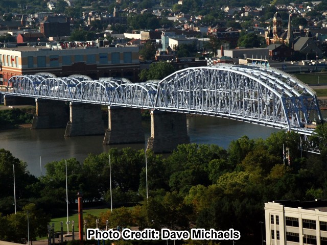
This monstrosity of a bridge, built in 1896, is complex to describe because so many spans compose it. In addition, some have been demolished over the years. Roughly, here is the story today. From north to south, there are two five panel Pratt deck truss spans, followed by a six panel deck truss, which long, long ago was actually a trapezoidal through truss span. Then comes the main span, a giant Pennsylvania through truss span. Continuing south, there are then four Parker truss spans. Continuing south off the river, there are a few deck plate girder spans, ending with a set of seven beautiful red brick arch spans.
The bridge's truss spans are pin connected. The design of the truss spans is extremely complex. Strictly speaking, the trusses are configured as truss spans with four truss lines that are not evenly spaced apart, which produces three roadways of varying width. There is one wide roadway, and one narrower roadway, and in between the two an extremely narrow roadway. However, to understand the way the spans are structured, the trusses might also be thought of as two parallel truss spans (each with the more typical two truss lines) that sit side by side, and have their struts and portal bracing tied together. In between the two trusses, a third roadway is created. Thinking of the bridge in this manner might make sense, since unlike the other areas of the bridge, the narrow middle roadway is devoid of sway bracing, and has only portal bracing and struts connecting the nearby truss spans. This tends to make the bridge look visually like two parallel trusses.
Numerous unusual details exist on the truss spans. A few examples include complicated diagonal member connections to the bottom chord, lateral bracing that is positioned so that it passes through holes in the deck stringers, and some sections of bottom chord that include both eyebar and built-up box beam in the same panel. The bottom chord in the main span is polygonal, another unusual detail. There is an extremely wide variety of member sizes, styles, and built-up beam configurations on this bridge. The bridge has an infinite number of details to look at, and to a casual observer it may seem that no two parts of the bridge are alike. The bridge has a listed vertical clearance of 21.1 feet.
This bridge once served both rail and vehicular traffic, until it was closed to all traffic in 2001. Fortunately, enough people cared about this spectacular bridge to restore it for pedestrian use. The bridge reopened to non-motorized traffic in 2003 under the ownership of a group dedicated to preserving and reusing the bridge. Since then, it has been a popular pedestrian crossing of the Ohio River in the area. Additionally, a plan in 2006 was undertaken to create a "bridge climb" which was ultimately unsuccessful due to a lack of popularity and was canceled a few years later. The "bridge climb" was perhaps unsuccessful because it was a lot of hassle for something that was not real special, and amounted to merely a walk on the top chord of the through trusses. Railings and stairs were added to the top chord for this purpose. Despite this, taking the climb also included a safety training before people could do the climb.
This bridge is the most historically significant surviving bridge in the area next to the Roebling Bridge itself, and the community responded appropriately to save a breathtaking structure. The bridge is an example of unusual bridge construction, utilizing unusual types of structural elements. The size of the bridge alone is significant, and the main span would have been a very long simple span when completed and thus is technologically significant. When other cities have demolished bridges as significant as this one, Cincinnati and Newport went in the other direction and saved this bridge.
As of 2013, there is currently a discussion about possibly constructing buildings on the bridge, for example, perhaps creating a hotel on a bridge. This would certainly be a unique adaptive reuse of a historic bridge. HistoricBridges.org hopes that any such reuse of the bridge will not obstruct all of the trusses and their historically significant details, and that the bridge will also maintain a roadway for pedestrians.
![]()
![]()
![]()
Coordinates (Latitude, Longitude):
Search For Additional Bridge Listings:
Bridgehunter.com: View listed bridges within 0.5 miles (0.8 kilometers) of this bridge.
Bridgehunter.com: View listed bridges within 10 miles (16 kilometers) of this bridge.
Additional Maps:
Google Streetview (If Available)
GeoHack (Additional Links and Coordinates)
Apple Maps (Via DuckDuckGo Search)
Apple Maps (Apple devices only)
Android: Open Location In Your Map or GPS App
Flickr Gallery (Find Nearby Photos)
Wikimedia Commons (Find Nearby Photos)
Directions Via Sygic For Android
Directions Via Sygic For iOS and Android Dolphin Browser
USGS National Map (United States Only)
Historical USGS Topo Maps (United States Only)
Historic Aerials (United States Only)
CalTopo Maps (United States Only)

© Copyright 2003-2026, HistoricBridges.org. All Rights Reserved. Disclaimer: HistoricBridges.org is a volunteer group of private citizens. HistoricBridges.org is NOT a government agency, does not represent or work with any governmental agencies, nor is it in any way associated with any government agency or any non-profit organization. While we strive for accuracy in our factual content, HistoricBridges.org offers no guarantee of accuracy. Information is provided "as is" without warranty of any kind, either expressed or implied. Information could include technical inaccuracies or errors of omission. Opinions and commentary are the opinions of the respective HistoricBridges.org member who made them and do not necessarily represent the views of anyone else, including any outside photographers whose images may appear on the page in which the commentary appears. HistoricBridges.org does not bear any responsibility for any consequences resulting from the use of this or any other HistoricBridges.org information. Owners and users of bridges have the responsibility of correctly following all applicable laws, rules, and regulations, regardless of any HistoricBridges.org information.
![]()