

View Information About HSR Ratings
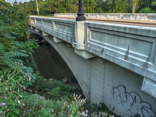
Although buried in the trees, this is an attractive medium size concrete arch bridge, noted for its ribbed design. The builder, Newton-Baxter Company of Toledo Ohio was organized by Stuart A. Baxter and Horace E. Newton in 1922.
Information and Findings From Ohio's Historic Bridge InventorySetting/Context The bridge carries a 2 lane street and sidewalks over a stream in a residential setting in Toledo. Physical Description The 3 span, 188'-long, 4-rib, closed-spandrel arch bridge has recessed-panel concrete parapets, cantilevered sidewalks with lozenged brackets, paneled spandrel walls to accent the arch ring, and horizontally scored pilasters at the piers. Integrity The bridge has been rehabilitated by the city (ca. 2000), but alterations/repairs were in-kind or sensitive to the original design/material. Summary of Significance "The 1927 ribbed deck arch bridge is handsomely detailed and proportioned It was rehabilitated without adverse effect. The eligible recommendation of the prior inventory remains appropriate. There are six closed spandrel ribbed arch bridges in the state, and all are eligible. The 2007-08 ODOT Historic Bridge Inventory Update (Phase 1A) has identified more than 225 extant, reinforced-concrete, closed-spandrel arch bridges dating from 1896 to 1959. Fewer than 30 examples date to before 1910. These tend to represent innovative technology or early attempts at exploring the aesthetic qualities of the moldable material; earlier examples tend to have higher historical and technological significance than the later examples. Use of the reinforced-concrete, closed-spandrel arch technology reached its height during the 1910s and 1920s with more than 80% of Ohio's surviving examples dating from those two decades. The later examples generally do not represent innovative technology, although they sometimes have high aesthetic merit or significant settings/contexts. ""Closed spandrel arch bridges are the most basic of reinforced concrete bridge types. Closed spandrel means that the area between the deck and the arch ring was filled in. The spandrel wall actually serves as a retaining wall in the bridge, holding the fill material. Live loads are borne by the fill material and by the spandrel walls. The arch may be constructed either as a single structural element (barrel) or in separate parallel longitudinal ribs. The barrel arch design has some structural and visual similarities to stone arch bridges. The barrel arch is also sometimes faced with brick or stone, making it appear similar to a masonry arch bridge. This type of bridge is suitable for short span lengths. Closed spandrel concrete arches predate open spandrels, as the closed spandrel type harkens back to the stone arches that the earliest forms imitated. This type was not built for long as engineers realized that significant material could be saved and a reduction in weight could be achieved by eliminating the filled section. Hence, open spandrels were born. Filled spandrel concrete arches date primarily from the earliest decades of reinforced concrete (1890s through 1920s). They are not as common as many of the standardized bridge types built during this same era, such as concrete slabs and girders. They are significant because they are not common and represent the evolution of concrete technology. To be considered significant, filled spandrel arches should have integrity, through the retention of their character-defining features: arch ring, barrel, spandrel wall, railing or parapet, end posts, piers and/or abutments and wingwalls."" [From: A Context for Common Historic Bridge Types by Parsons Brinckerhoff, October 2005]" Justification The bridge is a variation of the open spandrel arch, which is a common population in the state. The bridge has moderate significance. There are six ribbed closed spandrel arch bridges. Bridge Considered Historic By Survey: Yes |
![]()
![]()
![]()
Coordinates (Latitude, Longitude):
Search For Additional Bridge Listings:
Bridgehunter.com: View listed bridges within 0.5 miles (0.8 kilometers) of this bridge.
Bridgehunter.com: View listed bridges within 10 miles (16 kilometers) of this bridge.
Additional Maps:
Google Streetview (If Available)
GeoHack (Additional Links and Coordinates)
Apple Maps (Via DuckDuckGo Search)
Apple Maps (Apple devices only)
Android: Open Location In Your Map or GPS App
Flickr Gallery (Find Nearby Photos)
Wikimedia Commons (Find Nearby Photos)
Directions Via Sygic For Android
Directions Via Sygic For iOS and Android Dolphin Browser
USGS National Map (United States Only)
Historical USGS Topo Maps (United States Only)
Historic Aerials (United States Only)
CalTopo Maps (United States Only)

© Copyright 2003-2026, HistoricBridges.org. All Rights Reserved. Disclaimer: HistoricBridges.org is a volunteer group of private citizens. HistoricBridges.org is NOT a government agency, does not represent or work with any governmental agencies, nor is it in any way associated with any government agency or any non-profit organization. While we strive for accuracy in our factual content, HistoricBridges.org offers no guarantee of accuracy. Information is provided "as is" without warranty of any kind, either expressed or implied. Information could include technical inaccuracies or errors of omission. Opinions and commentary are the opinions of the respective HistoricBridges.org member who made them and do not necessarily represent the views of anyone else, including any outside photographers whose images may appear on the page in which the commentary appears. HistoricBridges.org does not bear any responsibility for any consequences resulting from the use of this or any other HistoricBridges.org information. Owners and users of bridges have the responsibility of correctly following all applicable laws, rules, and regulations, regardless of any HistoricBridges.org information.
![]()