

View Information About HSR Ratings
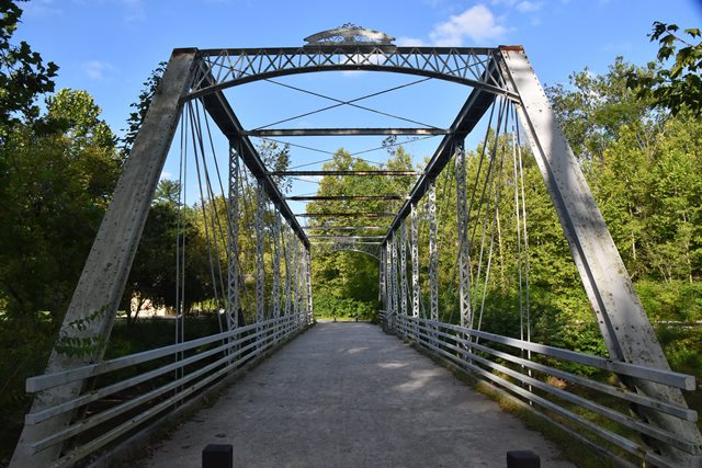
This rare Whipple truss bridge displays the unique Howe truss portal bracing of the Massillon Bridge Company. The bridge has been preserved in its original location for pedestrian use, the former highway now being a trail in a national park. It was rehabilitated in 1992, and again in 2021 when it was repainted.
Information and Findings From Ohio's Historic Bridge InventorySetting/Context The bridge carries a bike path over the Cuyahoga River in the Cuyahoga Valley National Park. Integrity Closed to traffic in 1988 and rehabilitated for pedestrian/bike use in 1992. Summary of Significance According to ODOT records, the 1882 double-intersection Pratt thru truss bridge is NR listed. Double-intersection Pratt trusses, also known as Whipple or Murphy-Whipple trusses, were among the most successful of long-span thru truss designs (up to 300' long) of the 1860s to 1890s for both railroad and vehicular crossings. Surviving examples are uncommon nationally and considered technologically significant; Ohio with at least 14 identified examples dating from 1881 to 1898 (Phase 1A survey, 2008) has a very high number in comparison to most other states. The truss design is characterized by diagonals that extend over two panels. In 1847, Squire Whipple, one of America's foremost bridge engineers, developed the design figuring that the double-intersection configuration increased the depth of panel without altering the optimal angle of the diagonals, thus allowing for increased span length. His design was further refined in 1859 by John W. Murphy, the talented chief engineer of Pennsylvania's Lehigh Valley RR, who substituted wrought-iron pins for cast-iron connecting pieces, thus developing the connection detail that would prove to be advanced construction practice for this and other truss designs for the next several decades. Ohio's surviving examples, which mostly date to the 1880s, were not cutting edge for their time, but they show how the form had evolved into the preferred long-span thru truss design of the period. Most have documented associations with prominent Ohio-based fabricators. Justification There are 13 examples of the bridge type important to the development and maturation of the pin-connected thru truss bridge. They date from 1881 and concentrated in the 1880s. Even though there are more than 12 extant examples in Ohio, each built in the 1880s has high significance based on overall scarcity (everywhere but in Ohio) of the design. This is a major and technologically significant bridge type. The bridge has high significance. Bridge Considered Historic By Survey: Yes |
![]()
![]()
![]()
Coordinates (Latitude, Longitude):
Search For Additional Bridge Listings:
Bridgehunter.com: View listed bridges within 0.5 miles (0.8 kilometers) of this bridge.
Bridgehunter.com: View listed bridges within 10 miles (16 kilometers) of this bridge.
Additional Maps:
Google Streetview (If Available)
GeoHack (Additional Links and Coordinates)
Apple Maps (Via DuckDuckGo Search)
Apple Maps (Apple devices only)
Android: Open Location In Your Map or GPS App
Flickr Gallery (Find Nearby Photos)
Wikimedia Commons (Find Nearby Photos)
Directions Via Sygic For Android
Directions Via Sygic For iOS and Android Dolphin Browser
USGS National Map (United States Only)
Historical USGS Topo Maps (United States Only)
Historic Aerials (United States Only)
CalTopo Maps (United States Only)

© Copyright 2003-2026, HistoricBridges.org. All Rights Reserved. Disclaimer: HistoricBridges.org is a volunteer group of private citizens. HistoricBridges.org is NOT a government agency, does not represent or work with any governmental agencies, nor is it in any way associated with any government agency or any non-profit organization. While we strive for accuracy in our factual content, HistoricBridges.org offers no guarantee of accuracy. Information is provided "as is" without warranty of any kind, either expressed or implied. Information could include technical inaccuracies or errors of omission. Opinions and commentary are the opinions of the respective HistoricBridges.org member who made them and do not necessarily represent the views of anyone else, including any outside photographers whose images may appear on the page in which the commentary appears. HistoricBridges.org does not bear any responsibility for any consequences resulting from the use of this or any other HistoricBridges.org information. Owners and users of bridges have the responsibility of correctly following all applicable laws, rules, and regulations, regardless of any HistoricBridges.org information.
![]()