

View Information About HSR Ratings
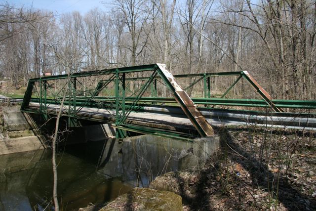
This pony truss is noteworthy for its unusual end post / top chord connection cover plates which double as builder plaques and list the Canton Bridge Company as builder. The bridge is an otherwise traditional structure and included built-up floorbeams. Original railings do not remain on the bridge.
This bridge has been altered at the end posts with additional welded materials added. Improperly mounted Armco guardrails detract from the visual quality of the bridge and do nothing to protect the fracture critical truss members of this historic bridge. Historic bridges like this one deserve to be better protected from the damage an automobile-bridge collision can cause, assuming there is in fact enough of a reason to put Armco guardrails on a quiet rural bridge like this one.
Information and Findings From Ohio's Historic Bridge InventorySetting/Context The bridge carries a 2 lane road over a stream in a sparsely developed, rural setting. Physical Description The 1 span, 53'-long, pin-connected Pratt pony truss bridge is traditionally composed of built-up compression members and eyebar or rod tension members. Summary of Significance The pin-connected Pratt pony truss was fabricated by the Canton Bridge Co. in 1910. It is a later example of a type/design that was developed prior to 1890 and is well represented by earlier and more distinguished examples throughout the state. The not eligible recommendation of the prior inventory remains appropriate. Bridge Considered Historic By Survey: No |
![]()
![]()
![]()
This historic bridge has been demolished. This map is shown for reference purposes only.
Coordinates (Latitude, Longitude):
Search For Additional Bridge Listings:
Bridgehunter.com: View listed bridges within 0.5 miles (0.8 kilometers) of this bridge.
Bridgehunter.com: View listed bridges within 10 miles (16 kilometers) of this bridge.
Additional Maps:
Google Streetview (If Available)
GeoHack (Additional Links and Coordinates)
Apple Maps (Via DuckDuckGo Search)
Apple Maps (Apple devices only)
Android: Open Location In Your Map or GPS App
Flickr Gallery (Find Nearby Photos)
Wikimedia Commons (Find Nearby Photos)
Directions Via Sygic For Android
Directions Via Sygic For iOS and Android Dolphin Browser
USGS National Map (United States Only)
Historical USGS Topo Maps (United States Only)
Historic Aerials (United States Only)
CalTopo Maps (United States Only)

© Copyright 2003-2026, HistoricBridges.org. All Rights Reserved. Disclaimer: HistoricBridges.org is a volunteer group of private citizens. HistoricBridges.org is NOT a government agency, does not represent or work with any governmental agencies, nor is it in any way associated with any government agency or any non-profit organization. While we strive for accuracy in our factual content, HistoricBridges.org offers no guarantee of accuracy. Information is provided "as is" without warranty of any kind, either expressed or implied. Information could include technical inaccuracies or errors of omission. Opinions and commentary are the opinions of the respective HistoricBridges.org member who made them and do not necessarily represent the views of anyone else, including any outside photographers whose images may appear on the page in which the commentary appears. HistoricBridges.org does not bear any responsibility for any consequences resulting from the use of this or any other HistoricBridges.org information. Owners and users of bridges have the responsibility of correctly following all applicable laws, rules, and regulations, regardless of any HistoricBridges.org information.
![]()