We Recommend:
Bach Steel - Experts at historic truss bridge restoration.
7 Mile Road Bridge

Primary Photographer(s): Nathan Holth
Bridge Documented: May 7, 2006
Rural: Preble County, Ohio: United States
1906 By Builder/Contractor: Indiana Bridge Company of Muncie, Indiana
1985
146.0 Feet (44.5 Meters)
155.0 Feet (47.2 Meters)
15.7 Feet (4.79 Meters)
1 Main Span(s)
6831826

View Information About HSR Ratings
Bridge Documentation
View Archived National Bridge Inventory Report - Has Additional Details and Evaluation
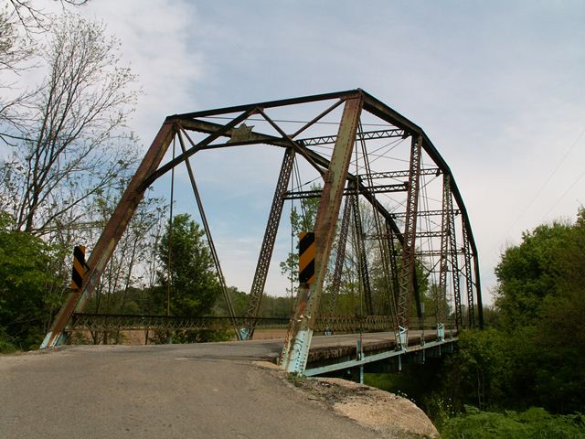
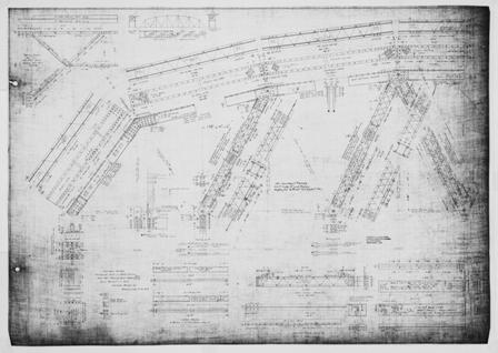
This bridge is one of only a couple surviving examples nationwide of a bridge design built by the Indiana Bridge Company of Muncie, Indiana and marketed as a High Triangular truss. The other is in Indiana. The truss design is unique, not copied by any other known company. It is essentially a pin-connected Polygonal Warren truss. Polygonal Warren truss bridges are otherwise limited to riveted connections among known surviving simple span truss bridges. The design of this bridge is similar, but not exactly the same as the patented Pegram truss bridge type. Indiana did additional research on the truss and found that in terms of engineering it functions differently than a true Pegram truss. In any case, as a rare surviving example of a highly unusual truss type, this bridge should receive the highest preservation priority.
A drawing from a "High Triangular" truss is shown to the right.
Cambria brands were found on the metal of this bridge. The bridge features pinned connections and is composed of six panels. The deck is wooden with an asphalt wearing surface. Original lattice railings remain on the bridge. The bridge's built-up beams include v-lacing, including some diagonal members that are are unusual box members with v-lacing on all four sides, an unusual detail that gives the members and open, lightweight appearance.
Information and Findings From Ohio's Historic Bridge InventorySetting/Context The bridge carries a 2 lane road over a stream in a rural setting of active agriculture. There are fields to the bridge's east. To the west is a rail line carried over Seven Mile Road by an overpass with a 9'6" vertical clearance. The bridge's western approach roadway is a sharp S-curve. Physical Description The 1-span, 155'-long, pin-connected Pegram thru truss bridge is composed of built-up compression members and eyebar tension members. The upper chords are toe-out channels with cover plate and lacing. The compression members in the web are toe-out channels with lacing. The tension members in the web and the lower chords are eyebars. The upper laterals are angles with lacing. The bridge has A-frame portals with builders plaques. The plaques read, "1906, Indianapolis Bridge Co., Muncie, Ind., S. C. Richie, Isaac Ulrich, J. E. Flora, Commissioners." There are original lattice railings. The floorbeam hangers are pin plates from the web members; the hangers do not connect to the lower chords, a characteristic of the Pegram design. There are rolled floorbeams, rolled stringers (with channel fasciae beams), and a wood deck. The bridge is supported on concrete abutments. Integrity Deck replaced, 1985. Welded stiffeners have been added at the floorbeam hangers. Summary of Significance The 1906 Pegram truss is a rare type/design in Ohio
that is technologically significant (Criterion C). There has been no
change in the bridge's status since the prior inventory. The eligible
recommendation remains appropriate. Justification The design is rare with this being the only example. It has exceptional significance. Bridge Considered Historic By Survey: Yes |
![]()
Photo Galleries and Videos: 7 Mile Road Bridge
Bridge Photo-Documentation
Original / Full Size PhotosA collection of overview and detail photos. This gallery offers photos in the highest available resolution and file size in a touch-friendly popup viewer.
Alternatively, Browse Without Using Viewer
![]()
Bridge Photo-Documentation
Mobile Optimized PhotosA collection of overview and detail photos. This gallery features data-friendly, fast-loading photos in a touch-friendly popup viewer.
Alternatively, Browse Without Using Viewer
![]()
Maps and Links: 7 Mile Road Bridge
Coordinates (Latitude, Longitude):
Search For Additional Bridge Listings:
Bridgehunter.com: View listed bridges within 0.5 miles (0.8 kilometers) of this bridge.
Bridgehunter.com: View listed bridges within 10 miles (16 kilometers) of this bridge.
Additional Maps:
Google Streetview (If Available)
GeoHack (Additional Links and Coordinates)
Apple Maps (Via DuckDuckGo Search)
Apple Maps (Apple devices only)
Android: Open Location In Your Map or GPS App
Flickr Gallery (Find Nearby Photos)
Wikimedia Commons (Find Nearby Photos)
Directions Via Sygic For Android
Directions Via Sygic For iOS and Android Dolphin Browser
USGS National Map (United States Only)
Historical USGS Topo Maps (United States Only)
Historic Aerials (United States Only)
CalTopo Maps (United States Only)


