

View Information About HSR Ratings

The informative sign near this bridge mentioned that the bridge was built as a relocation project after a devastating flood in 1913 that apparently wiped out the downtown bridge. Perhaps the stone piers visible next to the North Street Bridge are the remains of this former bridge?
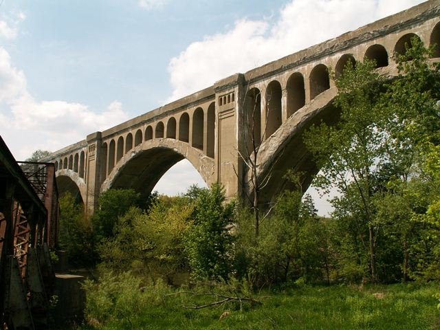
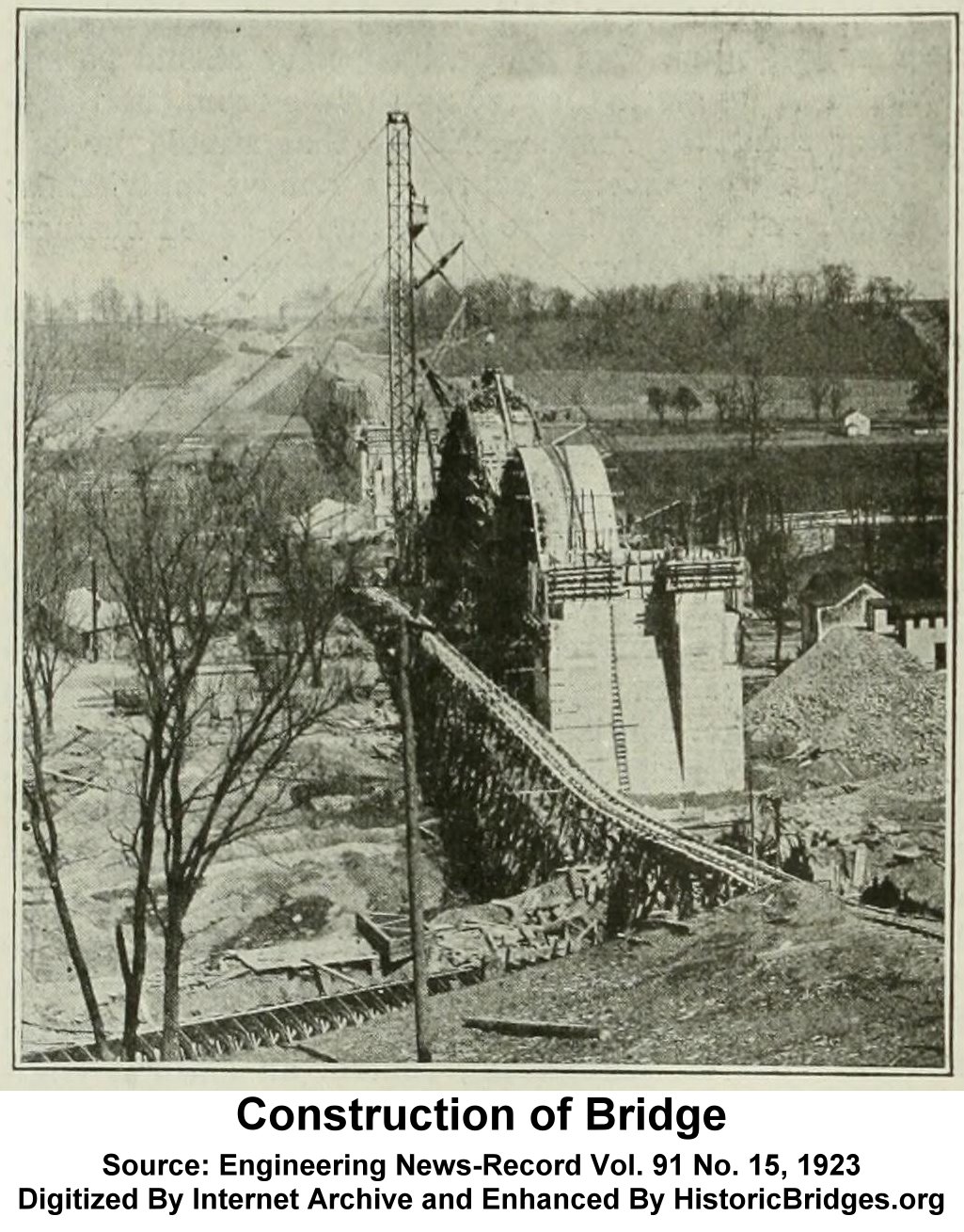
This bridge has a date cast into on a pier showing a 1923 construction date, but an informative plaque mounted near the bridge says it was opened in 1924. The sign also notes that five men died building this bridge. Particularly interesting, is that one of those workers is apparently still buried in the pier east of Main Avenue. Not a lot of OSHA safety going in the 1920s! Similar horror stories about people being buried in the concrete of the bridge have surfaced with other large concrete bridges like this one, and some of those stories appear to be more myth than truth. The validity of the buried person in this bridge is not known.
The fact that people died building this bridge is an example of why a bridge like this should be preserved. Maintaining and restoring a bridge such as this one honors the people who gave their lives to keep our country's road and rail networks connected and functioning. Beyond that, this bridge should be preserved because it is such an awesome bridge, and a landmark for Sidney. Unfortunately, this is not the case. Although the bridge appears to continue to serve railroad traffic, and is likely structurally sound given how massive it is, horrendous spalling of the concrete has occurred on the arch and this is reducing the bridge's beauty by slowly destroying the architectural details of this bridge.
This bridge is great for photographing, as there is a beautiful multi-span metal truss bridge next to this bridge. You can get excellent photos of the bridge with the truss bridge in the foreground. Like the Big Four Bridge however, this truss bridge is not being maintained (it is abandoned) and so it cannot be guaranteed that this bridge combination will remain forever.

![]()
![]()
![]()
Coordinates (Latitude, Longitude):
Search For Additional Bridge Listings:
Bridgehunter.com: View listed bridges within 0.5 miles (0.8 kilometers) of this bridge.
Bridgehunter.com: View listed bridges within 10 miles (16 kilometers) of this bridge.
Additional Maps:
Google Streetview (If Available)
GeoHack (Additional Links and Coordinates)
Apple Maps (Via DuckDuckGo Search)
Apple Maps (Apple devices only)
Android: Open Location In Your Map or GPS App
Flickr Gallery (Find Nearby Photos)
Wikimedia Commons (Find Nearby Photos)
Directions Via Sygic For Android
Directions Via Sygic For iOS and Android Dolphin Browser
USGS National Map (United States Only)
Historical USGS Topo Maps (United States Only)
Historic Aerials (United States Only)
CalTopo Maps (United States Only)

© Copyright 2003-2025, HistoricBridges.org. All Rights Reserved. Disclaimer: HistoricBridges.org is a volunteer group of private citizens. HistoricBridges.org is NOT a government agency, does not represent or work with any governmental agencies, nor is it in any way associated with any government agency or any non-profit organization. While we strive for accuracy in our factual content, HistoricBridges.org offers no guarantee of accuracy. Information is provided "as is" without warranty of any kind, either expressed or implied. Information could include technical inaccuracies or errors of omission. Opinions and commentary are the opinions of the respective HistoricBridges.org member who made them and do not necessarily represent the views of anyone else, including any outside photographers whose images may appear on the page in which the commentary appears. HistoricBridges.org does not bear any responsibility for any consequences resulting from the use of this or any other HistoricBridges.org information. Owners and users of bridges have the responsibility of correctly following all applicable laws, rules, and regulations, regardless of any HistoricBridges.org information.
![]()