

View Information About HSR Ratings
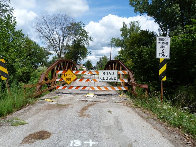
This bridge is not the oldest example of a riveted truss bridge, and in Morrow County's relatively large collection of surviving metal truss bridges it is far from the most noteworthy. However the bridge, with rolled beams and riveted connections is a good representative example of mid-20th Century truss bridge construction. Comparisons can be made between this bridge and older truss bridges in the county. Also, the bridge is far more attractive visually than any modern bridge could hope to be. The bridge has deteriorated and has been closed to traffic. However it likely could have been repaired and rehabilitated for less than the cost of replacement. Despite this, demolition and replacement has been chosen for this bridge.
Information and Findings From Ohio's Historic Bridge InventorySetting/Context The bridge carries a 2 lane road over a stream in a rural area of active farms. Summary of Significance The one span, riveted, Warren pony truss bridge with polygonal upper chords has rolled section for the members. It was fabricated for the county in 1951 by the Edwards Sheet Metal Works of Frederickton. It has concrete abutments and a laminated wood deck. Ohio Bridge Corp. replaced floor beams & deck in 1997. The bridge has no innovative or distinctive details and is an example of a type and design that was common by 1910. Bridge Considered Historic By Survey: No |
![]()
![]()
![]()
This historic bridge has been demolished. This map is shown for reference purposes only.
Coordinates (Latitude, Longitude):
Search For Additional Bridge Listings:
Bridgehunter.com: View listed bridges within 0.5 miles (0.8 kilometers) of this bridge.
Bridgehunter.com: View listed bridges within 10 miles (16 kilometers) of this bridge.
Additional Maps:
Google Streetview (If Available)
GeoHack (Additional Links and Coordinates)
Apple Maps (Via DuckDuckGo Search)
Apple Maps (Apple devices only)
Android: Open Location In Your Map or GPS App
Flickr Gallery (Find Nearby Photos)
Wikimedia Commons (Find Nearby Photos)
Directions Via Sygic For Android
Directions Via Sygic For iOS and Android Dolphin Browser
USGS National Map (United States Only)
Historical USGS Topo Maps (United States Only)
Historic Aerials (United States Only)
CalTopo Maps (United States Only)

© Copyright 2003-2024, HistoricBridges.org. All Rights Reserved. Disclaimer: HistoricBridges.org is a volunteer group of private citizens. HistoricBridges.org is NOT a government agency, does not represent or work with any governmental agencies, nor is it in any way associated with any government agency or any non-profit organization. While we strive for accuracy in our factual content, HistoricBridges.org offers no guarantee of accuracy. Information is provided "as is" without warranty of any kind, either expressed or implied. Information could include technical inaccuracies or errors of omission. Opinions and commentary are the opinions of the respective HistoricBridges.org member who made them and do not necessarily represent the views of anyone else, including any outside photographers whose images may appear on the page in which the commentary appears. HistoricBridges.org does not bear any responsibility for any consequences resulting from the use of this or any other HistoricBridges.org information. Owners and users of bridges have the responsibility of correctly following all applicable laws, rules, and regulations, regardless of any HistoricBridges.org information.
![]()