

View Information About HSR Ratings
A major engineering achievement when completed, today only the arch approach spans of this bridge are original. The concrete arches were built by C. H. Faith and Son Construction Company until the National Foundation and Engineering Company was organized to complete the work. More famous companies built the bascule span, including Kettler-Elliott Company of Chicago, Illinois and Toledo Bridge and Crane Company.
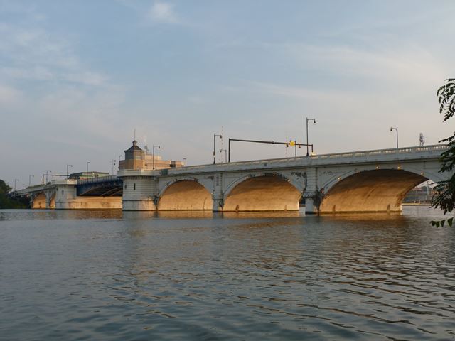
Information and Findings From Ohio's Historic Bridge InventorySetting/Context The bridge carries a 4 lane roadway over the Maumee River and Water Street in downtown Toledo. Physical Description The 17 span bridge consists of a 206'-long double-leaf bascule span flanked by 7 reinforced-concrete arch spans and 8 prestressed concrete beam spans placed in 2001-02 to replaced T beam spans. Integrity A major rehabilitation project in 2002 resulted in replacement of the bascule superstructure and operating systems. Operators houses were extensively modified with all new electrical and mechanical systems. The operating houses were rehabilitated with some consideration for maintaining original architectural details. All of the T beam approach spans were replaced. The arches were rehabilitated. Summary of Significance The Scherzer rolling lift bridge built in 1914 was rehabilitated in 2002 with an adverse effect. All of the movable bridge's superstructure and operating systems were replaced with a modern bascule span. It no longer conveys the technological significance of the Scherzer design due to loss of integrity of design and materials. The arches and piers are the only original fabric remaining from 1914. The bridge was eligible in the prior inventory, but due to the adverse effect it is now not eligible. Bridge Considered Historic By Survey: No |
![]()
![]()
![]()
Coordinates (Latitude, Longitude):
Search For Additional Bridge Listings:
Bridgehunter.com: View listed bridges within 0.5 miles (0.8 kilometers) of this bridge.
Bridgehunter.com: View listed bridges within 10 miles (16 kilometers) of this bridge.
Additional Maps:
Google Streetview (If Available)
GeoHack (Additional Links and Coordinates)
Apple Maps (Via DuckDuckGo Search)
Apple Maps (Apple devices only)
Android: Open Location In Your Map or GPS App
Flickr Gallery (Find Nearby Photos)
Wikimedia Commons (Find Nearby Photos)
Directions Via Sygic For Android
Directions Via Sygic For iOS and Android Dolphin Browser
USGS National Map (United States Only)
Historical USGS Topo Maps (United States Only)
Historic Aerials (United States Only)
CalTopo Maps (United States Only)

© Copyright 2003-2024, HistoricBridges.org. All Rights Reserved. Disclaimer: HistoricBridges.org is a volunteer group of private citizens. HistoricBridges.org is NOT a government agency, does not represent or work with any governmental agencies, nor is it in any way associated with any government agency or any non-profit organization. While we strive for accuracy in our factual content, HistoricBridges.org offers no guarantee of accuracy. Information is provided "as is" without warranty of any kind, either expressed or implied. Information could include technical inaccuracies or errors of omission. Opinions and commentary are the opinions of the respective HistoricBridges.org member who made them and do not necessarily represent the views of anyone else, including any outside photographers whose images may appear on the page in which the commentary appears. HistoricBridges.org does not bear any responsibility for any consequences resulting from the use of this or any other HistoricBridges.org information. Owners and users of bridges have the responsibility of correctly following all applicable laws, rules, and regulations, regardless of any HistoricBridges.org information.
![]()