We Recommend:
Bach Steel - Experts at historic truss bridge restoration.
Cleves Warsaw Road Bridge

Primary Photographer(s): Dave Michaels
Bridge Documented: November 21, 2006 and February 10, 2010
Rural: Hamilton County, Ohio: United States
1923 By Builder/Contractor: Brackett Bridge Company of Cincinnati, Ohio and Engineer/Design: Massillon Bridge and Structural Company
1970
232.0 Feet (70.7 Meters)
244.0 Feet (74.4 Meters)
24 Feet (7.32 Meters)
1 Main Span(s)
3132021

View Information About HSR Ratings
Bridge Documentation
This bridge no longer exists!
View Archived National Bridge Inventory Report - Has Additional Details and Evaluation
This historic bridge was demolished and replaced ca. 2012-2013!
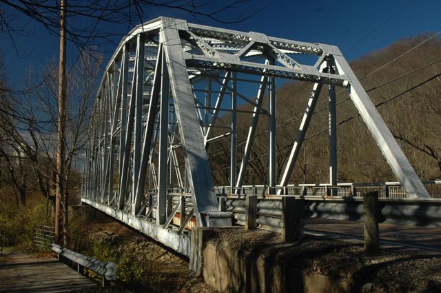
This bridge is a relatively large span example of a standard plan riveted truss bridge in Ohio. As such it is a visually impressive and historically noteworthy structure. The bridge appears to retain good historic integrity and is listed as possibly eligible for the National Register of Historic Places in the National Bridge Inventory.
Hamilton County has a hit or miss commitment to historic bridges. They have been responsible for some of the most senseless demolition projects imaginable (and of nationally significant bridges) but there are also several bridges in the county which have been preserved. It appears that the Cleves-Warsaw Road Bridge will become the latest pointless replacement. The county plans to demolish this historic bridge and replace it with a mundane slab of concrete in 2012.
The National Bridge Inventory ratings for this bridge are rather surprising and they raise some serious questions. The bridge's superstructure is listed as Critical (2/10) and the substructure is listed as serious (3/10). Bridges with a structural rating this low that are truly beyond repair normally have widespread deterioration that even a novice historic bridge enthusiast with no bridge inspection training could identify. However this bridge clearly does not have widespread deterioration, particularly in the metal truss superstructure. The only way such ratings could be valid is if there are a couple isolated but structurally important areas of the bridge that are in very bad shape. However if that was the case, then because the deterioration is isolated, repairs and rehabilitation should be more prudent than demolition and replacement. Regardless of the accuracy or cause of the National Bridge Inventory ratings, they have resulted in a very low 13.7% sufficiency rating, which would have made it extremely easy for Hamilton County to secure funding to demolish and replace the bridge.
HistoricBridges.org believes this bridge could have and should have been rehabilitated. Metal truss bridges have steadily declined in Hamilton County and far too few examples have been preserved. Further, the bridge was highlighted as one of the earliest examples of a state standard plan truss bridge.
Information and Findings From Ohio's Historic Bridge InventorySetting/Context The bridge carries a 2 lane road over a stream in a sparsely developed, rural setting. Physical Description The 1 span, 244'-long, rivet-connected Camelback thru truss bridge has built-up chords and rolled I-section web members. The middle panels are subdivided. The bridge has built-up upper lateral and sublateral crossbracing and trussed portal bracing. There is a cantilevered sidewalk to one side with metal-panel pipe railings. The floorbeams are built up and support stringers and a corrugated steel deck. Integrity Rehabilitated in 1970. Recent deck repairs. Summary of Significance There has been no significant change in the bridge's status since the prior inventory. The 1923 rivet-connected Camelback thru truss bridge is a complete example of its type/design with standard details, including the use of rolled sections, typical of the 1920s to 1950s. This is the oldest surviving examples designed by the state highway department using these standard details. It is technologically significant. Justification The bridge is one of over 40 extant riveted thru truss bridges of all designs built between 1904 and 1959. This example is representative of the population and has moderate significance. There are also many riveted thru truss bridges servicing the many rail lines in the state. Bridge Considered Historic By Survey: Yes |
![]()
Photo Galleries and Videos: Cleves Warsaw Road Bridge
Bridge Photo-Documentation
Original / Full Size PhotosA collection of overview and detail photos. This gallery offers photos in the highest available resolution and file size in a touch-friendly popup viewer.
Alternatively, Browse Without Using Viewer
![]()
Bridge Photo-Documentation
Mobile Optimized PhotosA collection of overview and detail photos. This gallery features data-friendly, fast-loading photos in a touch-friendly popup viewer.
Alternatively, Browse Without Using Viewer
![]()
Maps and Links: Cleves Warsaw Road Bridge
This historic bridge has been demolished. This map is shown for reference purposes only.
Coordinates (Latitude, Longitude):
Search For Additional Bridge Listings:
Bridgehunter.com: View listed bridges within 0.5 miles (0.8 kilometers) of this bridge.
Bridgehunter.com: View listed bridges within 10 miles (16 kilometers) of this bridge.
Additional Maps:
Google Streetview (If Available)
GeoHack (Additional Links and Coordinates)
Apple Maps (Via DuckDuckGo Search)
Apple Maps (Apple devices only)
Android: Open Location In Your Map or GPS App
Flickr Gallery (Find Nearby Photos)
Wikimedia Commons (Find Nearby Photos)
Directions Via Sygic For Android
Directions Via Sygic For iOS and Android Dolphin Browser
USGS National Map (United States Only)
Historical USGS Topo Maps (United States Only)
Historic Aerials (United States Only)
CalTopo Maps (United States Only)

