We Recommend:
Bach Steel - Experts at historic truss bridge restoration.
Pearl Street Railroad Overpass

Primary Photographer(s): Nathan Holth
Bridge Documented: May 7, 2006
Covington: Miami County, Ohio: United States
By Builder/Contractor: Unknown
Not Available or Not Applicable
Not Available
Not Available
Not Available
1 Main Span(s)
Not Applicable

View Information About HSR Ratings
Bridge Documentation
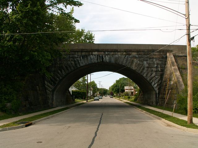
This bridge is one of two stone arch overpass bridges HistoricBridges.org documented in Covington in 2006. This single span bridge features a more round arch shape than its High Street neighbor, and spans a shorter distance as well. This railroad is long abandoned, and portions have been turned into rail-trails, and others have been removed completely. One section near this bridge was excavated away apparently to make way for some building. This project is apparently on-going and plans are to demolish this historic bridge. Covington already demolished another stone arch that was on Wall Street. Covington is foolish to destroy such beautiful examples of stone construction and engineering. Countless towns across the country are not blessed with these graceful structures, and as such these should instead be preserved. These bridges do not harm anything or anyone, except for perhaps trucks who might not be able to fit under them. However, it is likely that residents who live in the area do not mind any decrease in noisy truck traffic these bridges provide. Pearl Street is not a major through route anyhow and is instead a local residential street, so the "we need to demolish these bridges for truck traffic" excuse is void in this circumstance. Thus, there is not a single reason to demolish the Pearl Street Bridge, but there are many reasons to preserve it.
Note also that this rail line crosses the Stillwater River, and although this is an impressive two span stone arch bridge, it was too overgrown to photograph during HistoricBridges.org's 2006 visit.
![]()
Photo Galleries and Videos: Pearl Street Railroad Overpass
Bridge Photo-Documentation
Original / Full Size PhotosA collection of overview and detail photos. This gallery offers photos in the highest available resolution and file size in a touch-friendly popup viewer.
Alternatively, Browse Without Using Viewer
![]()
Bridge Photo-Documentation
Mobile Optimized PhotosA collection of overview and detail photos. This gallery features data-friendly, fast-loading photos in a touch-friendly popup viewer.
Alternatively, Browse Without Using Viewer
![]()
Maps and Links: Pearl Street Railroad Overpass
Coordinates (Latitude, Longitude):
Search For Additional Bridge Listings:
Bridgehunter.com: View listed bridges within 0.5 miles (0.8 kilometers) of this bridge.
Bridgehunter.com: View listed bridges within 10 miles (16 kilometers) of this bridge.
Additional Maps:
Google Streetview (If Available)
GeoHack (Additional Links and Coordinates)
Apple Maps (Via DuckDuckGo Search)
Apple Maps (Apple devices only)
Android: Open Location In Your Map or GPS App
Flickr Gallery (Find Nearby Photos)
Wikimedia Commons (Find Nearby Photos)
Directions Via Sygic For Android
Directions Via Sygic For iOS and Android Dolphin Browser
USGS National Map (United States Only)
Historical USGS Topo Maps (United States Only)
Historic Aerials (United States Only)
CalTopo Maps (United States Only)

