We Recommend:
Bach Steel - Experts at historic truss bridge restoration.
Foos Road Bridge
TR-437 Bridge

Primary Photographer(s): Nathan Holth
Bridge Documented: May 7, 2006
Rural: Preble County, Ohio: United States
1931 By Builder/Contractor: Brookville Bridge Company of Brookville, Ohio
Not Available or Not Applicable
65.0 Feet (19.8 Meters)
75.0 Feet (22.9 Meters)
20 Feet (6.1 Meters)
1 Main Span(s)
6840248

View Information About HSR Ratings
Bridge Documentation
View Archived National Bridge Inventory Report - Has Additional Details and Evaluation
About This Bridge
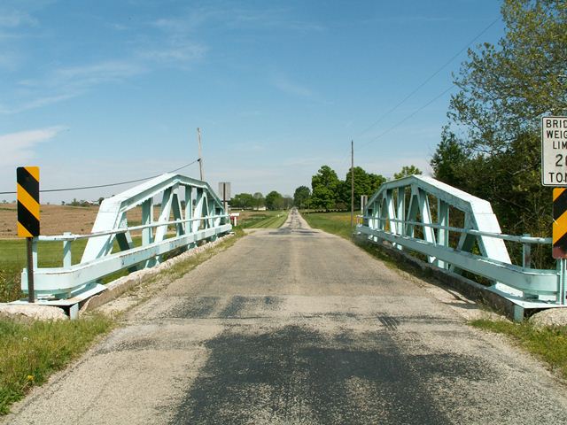
This bridge is a warren pony truss with riveted connections and a polygonal top chord. The bridge features v-lacing under the top chord. The deck is concrete with an asphalt wearing surface. There are rocker bearings at the east end of the bridge. There was another bridge similar to this on Camden College Corner Road. The bridges were built by the Brookville Bridge Company. Following the demolition of the Camden College Corner Road Bridge, this bridge should be reevaluated as having additional historic significance at the local level.
Two Nearby Tragedies on US-40: One a Bridge, Another a Man
There also used to be a two-span example of this bridge design, built by this bridge company, on nearby US-40. ODOT elected to demolish the bridge in 2002, rather than rehabilitating it, re-locating it, or bypassing it for preservation as a pedestrian structure. This is of course the first tragedy. The second happened long ago, when that US-40 Bridge was being built. As DOT's typically do, as "mitigation" for demolishing a historic bridge, they placed an interpretive plaque near the ugly replacement bridge. This plaque stated that the historic bridge "faithfully served the traveling public from 1926 to 2002." Of course it served traffic faithfully: it was a well-built pony truss! It would have continued to serve faithfully if it had been rehabilitated rather than obliterated by ODOT! ODOT also mounted a memorial plaque that came from the historic bridge when it was first constructed. As it turns out, it was on that US-40 Bridge, that Herman S. Fox, the president of the Brookville Bridge Company died while directing the construction. The plaque didn't say if the death was on or off site, nor whether it was from related to the construction of the bridge at all. This is one of the reasons why it is important to preserve historic truss bridges. Sometimes people died to build these bridges. Even if they didn't die while building them, they are still a tribute to the people who built them, a memorial of sorts. To destroy them, especially when numerous preservation alternatives are clearly available, is to desecrate a monument to their achievements as a person. With this bridge gone, it is clear additional need to preserve the Foos Road Bridge exists.
One aggravating thing was that the interpretive plaque on the US-40 Bridge dedicated the new, ugly bridge (which looks like little more than a slab of concrete) to Herman Fox. It is more of an insult than an honor to dedicate a slab of concrete to a bridge builder, or anyone for that matter. It would be like dedicating a toilet to someone! No one does that, because it would be interpreted as an insult. Instead, the preservation of the Foos Road Bridge would be a far better way to honor Herman Fox.
Information and Findings From Ohio's Historic Bridge InventorySetting/Context The bridge carries a 2 lane road over a stream in a rural area of active farms. Physical Description The 1 span, 75'-long, rivet-connected Warren pony truss has polygonal upper chord and verticals. The web members are rolled sections and the chords are built-up. Summary of Significance The 1931 Warren pony truss is a late example of its type/design with no distinguishing features. It has riveted connections, typical of Warren trusses from about 1900 to the 1940s when riveted connections began
to be phased out in favor of welded connections. The weld-connected Warren trusses continue to be a popular bridge type/design on county roads in Ohio. The survey has identified more than 500 pre-1961 Warren pony truss bridges,
making them the most common truss type/design surviving in the state. This example is not historically significant for its technology or context. More distinguished examples better represent the significance of the type/design in
the development of the state's road systems. The not eligible recommendation of the prior inventory remains appropriate. Bridge Considered Historic By Survey: No |
![]()
Photo Galleries and Videos: Foos Road Bridge
Bridge Photo-Documentation
Original / Full Size PhotosA collection of overview and detail photos. This gallery offers photos in the highest available resolution and file size in a touch-friendly popup viewer.
Alternatively, Browse Without Using Viewer
![]()
Bridge Photo-Documentation
Mobile Optimized PhotosA collection of overview and detail photos. This gallery features data-friendly, fast-loading photos in a touch-friendly popup viewer.
Alternatively, Browse Without Using Viewer
![]()
Maps and Links: Foos Road Bridge
Coordinates (Latitude, Longitude):
Search For Additional Bridge Listings:
Bridgehunter.com: View listed bridges within 0.5 miles (0.8 kilometers) of this bridge.
Bridgehunter.com: View listed bridges within 10 miles (16 kilometers) of this bridge.
Additional Maps:
Google Streetview (If Available)
GeoHack (Additional Links and Coordinates)
Apple Maps (Via DuckDuckGo Search)
Apple Maps (Apple devices only)
Android: Open Location In Your Map or GPS App
Flickr Gallery (Find Nearby Photos)
Wikimedia Commons (Find Nearby Photos)
Directions Via Sygic For Android
Directions Via Sygic For iOS and Android Dolphin Browser
USGS National Map (United States Only)
Historical USGS Topo Maps (United States Only)
Historic Aerials (United States Only)
CalTopo Maps (United States Only)

