We Recommend:
Bach Steel - Experts at historic truss bridge restoration.
Ketterman Road Bridge
TR-329 Bridge

Primary Photographer(s): Nathan Holth
Bridge Documented: May 7, 2006
Rural: Preble County, Ohio: United States
By Builder/Contractor: Unknown
Not Available or Not Applicable
46.0 Feet (14 Meters)
52.2 Feet (15.9 Meters)
15.7 Feet (4.79 Meters)
1 Main Span(s)
6838405

View Information About HSR Ratings
Bridge Documentation
This bridge no longer exists!
View Archived National Bridge Inventory Report - Has Additional Details and Evaluation
This historic bridge was demolished and replaced in 2011!
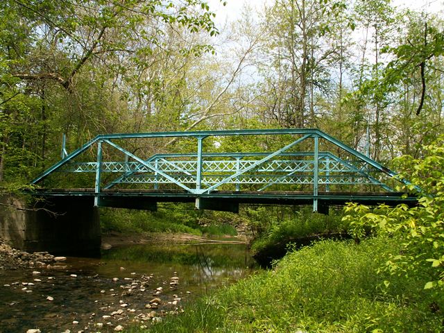
Speaking in terms of panels, this four panel Pratt truss has the least number of panels that a "full-slope" Pratt can have. Only a half-hip Pratt could have less.
This attractive bridge features original lattice railings and sits on concrete abutments. Despite a complete lack of v-lacing on its members and chords, this bridge is a very picturesque small bridge. Nestled back in the woods on a quiet rural road, this bridge with its blue paint looked nice against the green trees and a stony Aukerman Creek running under it. This bridge shows how a vibrant paint color can help a historic truss bridge stand out. It really showed its potential here, where the soft, but noticeable paint color helps the bridge stand out and be noticed, but yet not look too gaudy. Sometimes, restored historic truss bridges get painted darker, bland colors like brown or black, and these colors tend to hide the details of the truss and do not help it stand out.
Regardless of its attributes, this historic bridge was demolished and replaced with an ugly modern bridge that looks like little more than a slab of concrete. Despite the small size of this bridge which would result in inexpensive restoration costs, and the non-existent traffic that a modern two-lane bridge serves here, this historic artifact has been lost forever thanks to shortsightedness and wasteful spending. The new bridge is a distasteful scar on the scenic wooded landscape in the area.
Information and Findings From Ohio's Historic Bridge InventorySetting/Context The bridge carries a 1-lane road over a stream in a wooded rural setting. There is a modern house beyond one quadrant. Physical Description The 1-span, 52'-long, rivet-connected, Pratt pony truss bridge is supported on concrete abutments. The bridge's members are built-up with toe-out channels with cover plate and battens for the upper chords. The verticals were originally two pairs of angles, but these have been truncated/altered at about mid-height and strengthened by the addition of welded channels that continue downward to pick up the floorbeams by welded connections, replacing the original riveted connections. Some rivets have also been replaced at the lower panel gusset plates. The lower chords and diagonals are paired channels with battens. At the ends of the truss, plate has been welded to the lower chords and end-post cover plates as a strengthening measure. The bridge has rolled floorbeams, stringers, and a timber deck. The floorbeams have been strengthened by the addition of welded channels to the lower flanges at the ends of the beams. Riveted lattice railings are placed inside the truss lines. There is no builder's plaque. Integrity The integrity of original design has been compromised by the alterations to the riveted connections at the lower panel points, including replacement of rivets with bolts and welded connections. Many members (verticals, end posts, lower chords, and floorbeams) have irreversible welded repairs and the addition of plate. The welded repairs appear to post-date the prior ODOT truss survey photos (ca. 1980). Summary of Significance The rivet-connected Pratt pony truss dates ca. 1915 by style but the builder is not documented by available county records. It has alterations that have impacted the integrity of original design, significantly
impacting the appearance and function of the truss connections. More complete and documented examples of riveted-connected trusses of similar age and design have been identified and better represent the significance of the truss
type to the development of Ohio's highway systems. The not eligible recommendation of the prior inventory remains appropriate. Bridge Considered Historic By Survey: No |
![]()
Photo Galleries and Videos: Ketterman Road Bridge
Bridge Photo-Documentation
Original / Full Size PhotosA collection of overview and detail photos. This gallery offers photos in the highest available resolution and file size in a touch-friendly popup viewer.
Alternatively, Browse Without Using Viewer
![]()
Bridge Photo-Documentation
Mobile Optimized PhotosA collection of overview and detail photos. This gallery features data-friendly, fast-loading photos in a touch-friendly popup viewer.
Alternatively, Browse Without Using Viewer
![]()
Maps and Links: Ketterman Road Bridge
This historic bridge has been demolished. This map is shown for reference purposes only.
Coordinates (Latitude, Longitude):
Search For Additional Bridge Listings:
Bridgehunter.com: View listed bridges within 0.5 miles (0.8 kilometers) of this bridge.
Bridgehunter.com: View listed bridges within 10 miles (16 kilometers) of this bridge.
Additional Maps:
Google Streetview (If Available)
GeoHack (Additional Links and Coordinates)
Apple Maps (Via DuckDuckGo Search)
Apple Maps (Apple devices only)
Android: Open Location In Your Map or GPS App
Flickr Gallery (Find Nearby Photos)
Wikimedia Commons (Find Nearby Photos)
Directions Via Sygic For Android
Directions Via Sygic For iOS and Android Dolphin Browser
USGS National Map (United States Only)
Historical USGS Topo Maps (United States Only)
Historic Aerials (United States Only)
CalTopo Maps (United States Only)

