

View Information About HSR Ratings
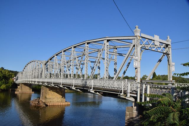
This is a beautiful bridge with unique details that appear to somewhat replicate the design of the previous bridge at this location, in terms of the Parker truss with rare vertical end posts, and large ornamental finials. The previous bridge served for only 13 years before the Great Flood of 1913 destroyed it. This bridge replaced it.
The bridge has a unique ornate riveted railing on the outside of the sidewalk. There also is a completely different ornamental railing on the inside of the sidewalk. The inside railing looks like it might have been salvaged from another bridge, it is a beautiful old riveted railing, but does not match the outside sidewalk railing. It was not salvaged from the bridge destroyed in the flood, because it had a different railing design.
The bridge from southwest to northeast consists of a a 32 foot steel stringer span, a 7 panel 166 foot Parker truss span, an 11 panel 203 foot Parker through truss span, and lastly a Parker swing span which HistoricBridges.org estimates at a 190 foot span. The swing span is very similar in appearance to the fixed truss spans, except for a larger, heavy vertical member over the swing pier, and a lighter weight top chord and end post compared to the fixed spans. The swing span has not operated for boats for many years. However the gears and rack are in place, and the span still conveys its function as a swing span.

Above: Historical photo showing the previous bridge at this location. Note the similar design details in terms of vertical end posts, and ornamental end post finials. Note however it was a pin-connected structure.
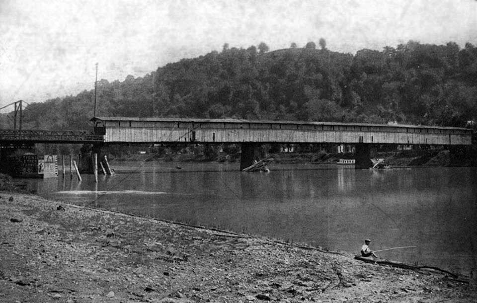
Above: An earlier bridge at this location. Note the swing span to the left.
Information and Findings From Ohio's Historic Bridge InventorySetting/Context The bridge carries a 2-lane highway over the Muskingum River between McConnelsville and Malta villages. Physical Description The 4-span bridge consists of a 122'-long thru-truss swing span at one end and 2 Parker thru truss spans of approximately 166' and 203'. There is also a shorter 32'-long span that according to the old ODOT survey form is also a swing span. The rivet-connected trusses are conventionally composed of built-up members. The portal bracing is finished with finials. The movable spans are not operable. Summary of Significance The 1913 swing span bridge, although inoperable, is among the oldest movable highway bridges surviving in Ohio and significant in association with the development of the Muskingum Navigation. There has been no significant change in the bridge's status since the prior inventory. The select recommendation of the prior inventory remains appropriate. [Note: the bridge may be NR-listed, a penciled notation on the ODOT survey suggests it is; it's not individual, so it may be contributing to a HD.] Justification The bridge is one of over 40 extant riveted thru truss bridges of all designs built between 1904 and 1959. This example is representative of the population and has moderate significance. There are also many riveted thru truss bridges servicing the many rail lines in the state. Bridge Considered Historic By Survey: Yes |
![]()
![]()
![]()
Coordinates (Latitude, Longitude):
Search For Additional Bridge Listings:
Bridgehunter.com: View listed bridges within 0.5 miles (0.8 kilometers) of this bridge.
Bridgehunter.com: View listed bridges within 10 miles (16 kilometers) of this bridge.
Additional Maps:
Google Streetview (If Available)
GeoHack (Additional Links and Coordinates)
Apple Maps (Via DuckDuckGo Search)
Apple Maps (Apple devices only)
Android: Open Location In Your Map or GPS App
Flickr Gallery (Find Nearby Photos)
Wikimedia Commons (Find Nearby Photos)
Directions Via Sygic For Android
Directions Via Sygic For iOS and Android Dolphin Browser
USGS National Map (United States Only)
Historical USGS Topo Maps (United States Only)
Historic Aerials (United States Only)
CalTopo Maps (United States Only)

© Copyright 2003-2024, HistoricBridges.org. All Rights Reserved. Disclaimer: HistoricBridges.org is a volunteer group of private citizens. HistoricBridges.org is NOT a government agency, does not represent or work with any governmental agencies, nor is it in any way associated with any government agency or any non-profit organization. While we strive for accuracy in our factual content, HistoricBridges.org offers no guarantee of accuracy. Information is provided "as is" without warranty of any kind, either expressed or implied. Information could include technical inaccuracies or errors of omission. Opinions and commentary are the opinions of the respective HistoricBridges.org member who made them and do not necessarily represent the views of anyone else, including any outside photographers whose images may appear on the page in which the commentary appears. HistoricBridges.org does not bear any responsibility for any consequences resulting from the use of this or any other HistoricBridges.org information. Owners and users of bridges have the responsibility of correctly following all applicable laws, rules, and regulations, regardless of any HistoricBridges.org information.
![]()