

View Information About HSR Ratings
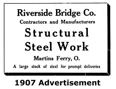
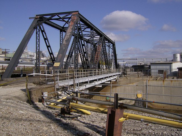
This is a traditionally composed railroad truss bridge that is currently configured with a mixed use deck that also accepts vehicular traffic. It is a rare surviving example of a bridge known to have been built by the Riverside Bridge Company of Martins Ferry, Ohio. Owned by the companies whose factories surround the bridge, the bridge was originally built for Procter and Gamble's Crisco plant in St. Bernard. The bridge was rehabilitated in 1997, but by 2007 the need additional work was identified. Smuckers (who owns the Crisco plant) and FeldaIFFCO (who owns the Olestra plant) combined funds to rehabilitate the bridge in 2011. The decision to rehabilitate the bridge was made when it was found to be more economical than demolition and replacement. This is not unusual; historic truss bridges can often be rehabilitated for less than the cost of demolition and replacement. The rehabilitation schedule was eight months and the goal was to keep the bridge open as much as possible during the project. The project was completed with a single 10 day bridge shutdown, and scattered 2 day shutdowns throughout the project duration. The project scope of work included replacing deck stringers and lateral bracing under the deck as well as repainting the bridge.
![]()
![]()
![]()

![]()
This privately owned bridge is located within private property and is not open to the public.
Coordinates (Latitude, Longitude):
Search For Additional Bridge Listings:
Bridgehunter.com: View listed bridges within 0.5 miles (0.8 kilometers) of this bridge.
Bridgehunter.com: View listed bridges within 10 miles (16 kilometers) of this bridge.
Additional Maps:
Google Streetview (If Available)
GeoHack (Additional Links and Coordinates)
Apple Maps (Via DuckDuckGo Search)
Apple Maps (Apple devices only)
Android: Open Location In Your Map or GPS App
Flickr Gallery (Find Nearby Photos)
Wikimedia Commons (Find Nearby Photos)
Directions Via Sygic For Android
Directions Via Sygic For iOS and Android Dolphin Browser
USGS National Map (United States Only)
Historical USGS Topo Maps (United States Only)
Historic Aerials (United States Only)
CalTopo Maps (United States Only)

© Copyright 2003-2024, HistoricBridges.org. All Rights Reserved. Disclaimer: HistoricBridges.org is a volunteer group of private citizens. HistoricBridges.org is NOT a government agency, does not represent or work with any governmental agencies, nor is it in any way associated with any government agency or any non-profit organization. While we strive for accuracy in our factual content, HistoricBridges.org offers no guarantee of accuracy. Information is provided "as is" without warranty of any kind, either expressed or implied. Information could include technical inaccuracies or errors of omission. Opinions and commentary are the opinions of the respective HistoricBridges.org member who made them and do not necessarily represent the views of anyone else, including any outside photographers whose images may appear on the page in which the commentary appears. HistoricBridges.org does not bear any responsibility for any consequences resulting from the use of this or any other HistoricBridges.org information. Owners and users of bridges have the responsibility of correctly following all applicable laws, rules, and regulations, regardless of any HistoricBridges.org information.
![]()