

View Information About HSR Ratings
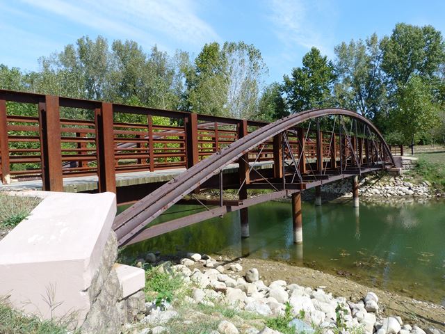
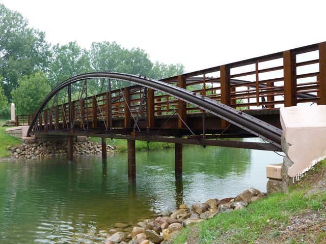
This bridge was previously located at Wakatomika Creek on Mill Road (Coordinates: 40.27667, -82.27167) in rural Knox County. As of 2014, this bridge has been relocated and preserved here in a Mt. Vernon park for pedestrian use. The bridge is a beautiful and exceedingly rare historic centerpiece for the new Ariel-Foundation Park.
1870s style iron bowstring bridges of any kind are rare. However, this bridge is particularly rare for its use of a genuine Phoenix column for the top chord. The Wrought Iron Bridge Company typically used a built-up column for its bowstring truss bridges that resembled the design of a column called a Keystone column (whether they were using true Keystone columns from the Union Iron Mills is debatable however). This bridge in contrast uses the slightly different patented Phoenix column. Not only does the circular cross section of the column give the Phoenix design away, the columns retain clearly the Phoenix name and patent date on them.
When the bridge was moved here, some repairs were made to the bowstring. Whenever something was repaired or replaced, any rivets removed were replaced in-kind with rivets (not modern bolts) which is outstanding because it maintains the appearance and historic integrity of the bridge. The bridge was not painted... which is not a big deal because the historic bridge is composed of rust-resistant cast and wrought iron which weathers far better than modern steel. Its a great solution to save money on a wrought iron bridge preservation project.
There are a couple mysteries with the relocation however. Firstly, the bridge was placed on modern steel stringers which are supported by piers. The bowstring thus is only decorative and does not function to bear any load. It is unclear why this was done... structurally, bowstrings of this type can safely carry pedestrian and light vehicular traffic if restored. Using the load-bearing stringers in this instance seems like it would only serve to increase cost to preserve the bridge (or divert funds that could otherwise have been used to more extensively restore the bowstring). The fact that the stringers include piers also gives the bridge a bit of a fake look, and gives away the alteration. The final mystery with this bridge is why some top chord splice plates which were re-riveted on the bridge were not replaced. Some of these plates were highly deteriorated and cracked when they were re-riveted. As they are composed of simple place, replacing them would not have been costly.
Information and Findings From Ohio's Historic Bridge InventorySummary of Significance See HAER OH-91. A very significant surviving example of the bowstring type/design of the WIBCo with Phoenix column top chord. The bridge is NR listed (1979). Currently on an abandoned road and closed to traffic, the county plans to relocate it to Foundation Park in Mt. Vernon. Bowstring trusses are characterized by arched top chords and a trussed or lattice web. They rank among the rarest and most technologically significant of 19th-century metal truss designs since they appeared early in the evolution of iron bridge development and were almost always based on the patents or proprietary designs of bridge builders and engineers. The progenitor of the form was the famed engineer Squire Whipple of New York, who built the first example in 1840 over the Erie Canal at Utica. After the Civil War, Ohio was a center for the development of the bowstring with its concentration of metal bridge-building companies. Companies such Wrought Iron Bridge, Champion Bridge, Massillon Bridge, and King Iron Bridge built their reputations on successful bowstring designs with a dizzying number of variant ways of forming and connecting the truss members. The companies emerged in time to fill the burgeoning demand for an economical, prefabricated bridge for use on American roads. Bowstring trusses thus document this exceptionally inventive and technologically significant period in the development of American metal trusses from the 1860s to early 1880s. The ODOT inventory has identified 22 surviving examples dating from ca. 1864 to 1880 (Phase 1A, 2008). Justification The bridge is one of the 22 extant bowstring truss bridges that survive in the state. Having so many is remarkable, and even though they are "common" based on their numbers, each is an important and irreplaceable record of the development of the metal truss bridge and the ingenuity associated with the Ohio industrial development. The bridge has high significance. Bridge Considered Historic By Survey: Yes |
This bridge is tagged with the following special condition(s): Phoenix Columns and Unorganized Photos
![]()
![]()
![]()
![]()
![]()
Coordinates (Latitude, Longitude):
Search For Additional Bridge Listings:
Bridgehunter.com: View listed bridges within 0.5 miles (0.8 kilometers) of this bridge.
Bridgehunter.com: View listed bridges within 10 miles (16 kilometers) of this bridge.
Additional Maps:
Google Streetview (If Available)
GeoHack (Additional Links and Coordinates)
Apple Maps (Via DuckDuckGo Search)
Apple Maps (Apple devices only)
Android: Open Location In Your Map or GPS App
Flickr Gallery (Find Nearby Photos)
Wikimedia Commons (Find Nearby Photos)
Directions Via Sygic For Android
Directions Via Sygic For iOS and Android Dolphin Browser
USGS National Map (United States Only)
Historical USGS Topo Maps (United States Only)
Historic Aerials (United States Only)
CalTopo Maps (United States Only)

© Copyright 2003-2024, HistoricBridges.org. All Rights Reserved. Disclaimer: HistoricBridges.org is a volunteer group of private citizens. HistoricBridges.org is NOT a government agency, does not represent or work with any governmental agencies, nor is it in any way associated with any government agency or any non-profit organization. While we strive for accuracy in our factual content, HistoricBridges.org offers no guarantee of accuracy. Information is provided "as is" without warranty of any kind, either expressed or implied. Information could include technical inaccuracies or errors of omission. Opinions and commentary are the opinions of the respective HistoricBridges.org member who made them and do not necessarily represent the views of anyone else, including any outside photographers whose images may appear on the page in which the commentary appears. HistoricBridges.org does not bear any responsibility for any consequences resulting from the use of this or any other HistoricBridges.org information. Owners and users of bridges have the responsibility of correctly following all applicable laws, rules, and regulations, regardless of any HistoricBridges.org information.
![]()