

View Information About HSR Ratings
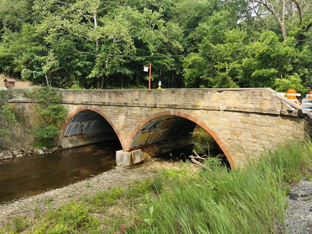
This uncommon example of an unusual bridge type remains standing despite repeated attacks by bad drivers. The bridge's parapets were documented as having been damaged in 2007, and during a 2021 field visit, additional damage (including a discarded car bumper) were found along the creek next to the bridge.
This bridge was a type excluded by the Historic Bridge Inventory. It is not clear why. In HistoricBridges.org's experience, stone faced corrugated multi-plate arch bridges are uncommon. Most, like this bridge, seem to date to the 1930s, and HistoricBridges.org suspects some of them may have been products of Depression era relief programs, which would add to their historic significance. Stone briefly returned from years of disuse as favored material in many Depression-era projects, although being as it was the 1930s, often the stone was combined with modern materials like steel corrugated multi-plate, or concrete.
Information and Findings From Ohio's Historic Bridge InventorySummary of Significance Although coded as a stone arch in BMS, the bridge is actually a steel multi-plate arch with stone spandrel walls. The 1935 date of construction is correct. The bridge is an excluded bridge type that has been recommended not eligible based on the context of its type/design and date of construction. The non-select recommendation of the prior inventory remains appropriate. Bridge Considered Historic By Survey: No |
![]()
![]()
![]()
Coordinates (Latitude, Longitude):
Search For Additional Bridge Listings:
Bridgehunter.com: View listed bridges within 0.5 miles (0.8 kilometers) of this bridge.
Bridgehunter.com: View listed bridges within 10 miles (16 kilometers) of this bridge.
Additional Maps:
Google Streetview (If Available)
GeoHack (Additional Links and Coordinates)
Apple Maps (Via DuckDuckGo Search)
Apple Maps (Apple devices only)
Android: Open Location In Your Map or GPS App
Flickr Gallery (Find Nearby Photos)
Wikimedia Commons (Find Nearby Photos)
Directions Via Sygic For Android
Directions Via Sygic For iOS and Android Dolphin Browser
USGS National Map (United States Only)
Historical USGS Topo Maps (United States Only)
Historic Aerials (United States Only)
CalTopo Maps (United States Only)

© Copyright 2003-2024, HistoricBridges.org. All Rights Reserved. Disclaimer: HistoricBridges.org is a volunteer group of private citizens. HistoricBridges.org is NOT a government agency, does not represent or work with any governmental agencies, nor is it in any way associated with any government agency or any non-profit organization. While we strive for accuracy in our factual content, HistoricBridges.org offers no guarantee of accuracy. Information is provided "as is" without warranty of any kind, either expressed or implied. Information could include technical inaccuracies or errors of omission. Opinions and commentary are the opinions of the respective HistoricBridges.org member who made them and do not necessarily represent the views of anyone else, including any outside photographers whose images may appear on the page in which the commentary appears. HistoricBridges.org does not bear any responsibility for any consequences resulting from the use of this or any other HistoricBridges.org information. Owners and users of bridges have the responsibility of correctly following all applicable laws, rules, and regulations, regardless of any HistoricBridges.org information.
![]()