

View Information About HSR Ratings
One of several surviving stone arch bridges, many at least partially rehabbed, among the oldest in Ohio, that originally served the Miami and Erie Canal, but not carries a highway.
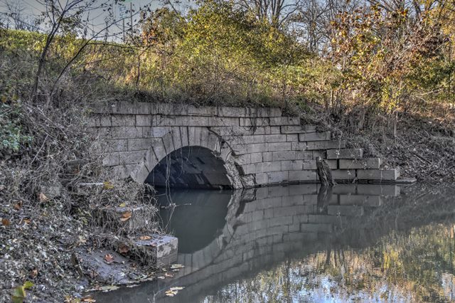
Information and Findings From Ohio's Historic Bridge InventorySetting/Context The culvert is located under earth fill and is not visible from the 2-lane roadway. The setting is rural. The roadway is built on the right-of-way of the former Miami & Erie Canal. The Miami & Erie Canal was completed in 1845. It connected the Ohio River at Cincinnati with Lake Erie at Toledo. Physical Description The 1 span, 20'-long arch culvert has coursed ashlar spandrel walls, arch barrel, and wingwalls. The spandrel walls and wingwalls show evidence of shifting/missing stones. A section of the spandrel wall at one elevation has failed and the other side has been raised with a later generation of masonry by evidence of the different size/finish of the stones. Integrity One spandrel wall has failed. Complete failure imminent. Severe condition. Other side also has problems. Summary of Significance The stone arch culvert is one in a series of eight ca. 1842 aqueducts that now carry SR 24 and SR 424 over streams in Henry County along the north shore of the Maumee River. The highways are built on the alignment of the 1832-1842 or 1845 Wabash & Erie Canal (W&E) that linked Lake Erie at Toledo with the Ohio River at Evansville. At Junction in Paulding County the W&E Canal joined the Miami and Ohio Canal to Cincinnati (see 6333230). While the W&E did much to stimulate the historic development of Toledo as a great lake port, the ambitious canals, which were expensive for Ohio and particularly Indiana to construct, were completed about the time the railroads came into prominence. By the Civil War, the railroads had eclipsed the canals for shipping goods and materials thus driving the canals into decline. The W&E was abandoned was abandoned in 1909. Period accounts report that many sections, which were in bad repair at the time of abandonment, had disappeared by 1913. The canal was largely drained in 1929, and in selected locations, highways and roads were constructed on the filled canal like SR 424 along the north shore of the Maumee River in Henry County or TR 153 in Paulding County. Ohio's eastern and western canals represent a significant historic context documenting our young nation's approach to developing internal improvements and linking regions and markets. The aqueducts of the Wabash & Erie Canal are historically and technologically significant for their association with the canal. They chronicle an important aspect of American history, settlement and development, and roots of our economy. All are eligible; eight in Henry County and one in Paulding County) for their association with the canal. Justification A well represented bridge type throughout the state for both bridges and culverts, stone arch bridges date from the mid 1830s and the building of the National Road through Belmont Co. Many are superbly proportioned and constructed by local contractors. They were used built through World War I, particularly during the later years in park settings. More than 125 examples remain. This example has moderate significance based on loss of integrity and comparison with a more complete aqueduct for the same canal in Paulding Co. Bridge Considered Historic By Survey: Yes |
![]()
![]()
![]()
Coordinates (Latitude, Longitude):
Search For Additional Bridge Listings:
Bridgehunter.com: View listed bridges within 0.5 miles (0.8 kilometers) of this bridge.
Bridgehunter.com: View listed bridges within 10 miles (16 kilometers) of this bridge.
Additional Maps:
Google Streetview (If Available)
GeoHack (Additional Links and Coordinates)
Apple Maps (Via DuckDuckGo Search)
Apple Maps (Apple devices only)
Android: Open Location In Your Map or GPS App
Flickr Gallery (Find Nearby Photos)
Wikimedia Commons (Find Nearby Photos)
Directions Via Sygic For Android
Directions Via Sygic For iOS and Android Dolphin Browser
USGS National Map (United States Only)
Historical USGS Topo Maps (United States Only)
Historic Aerials (United States Only)
CalTopo Maps (United States Only)

© Copyright 2003-2024, HistoricBridges.org. All Rights Reserved. Disclaimer: HistoricBridges.org is a volunteer group of private citizens. HistoricBridges.org is NOT a government agency, does not represent or work with any governmental agencies, nor is it in any way associated with any government agency or any non-profit organization. While we strive for accuracy in our factual content, HistoricBridges.org offers no guarantee of accuracy. Information is provided "as is" without warranty of any kind, either expressed or implied. Information could include technical inaccuracies or errors of omission. Opinions and commentary are the opinions of the respective HistoricBridges.org member who made them and do not necessarily represent the views of anyone else, including any outside photographers whose images may appear on the page in which the commentary appears. HistoricBridges.org does not bear any responsibility for any consequences resulting from the use of this or any other HistoricBridges.org information. Owners and users of bridges have the responsibility of correctly following all applicable laws, rules, and regulations, regardless of any HistoricBridges.org information.
![]()