

View Information About HSR Ratings

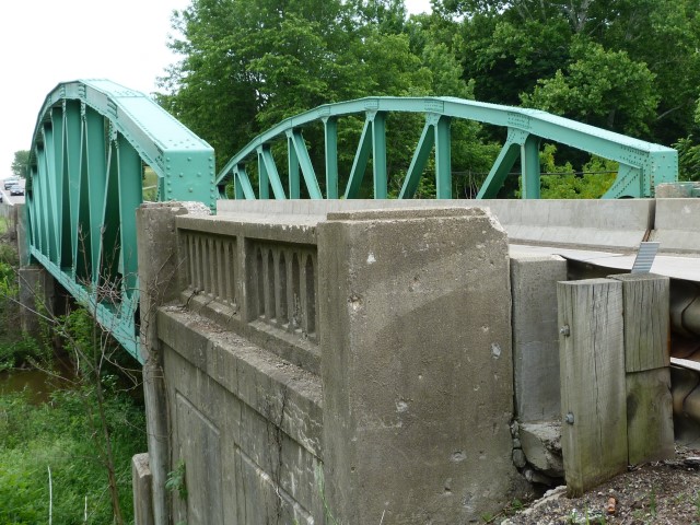
This pony truss is a very unusual and visually distinctive bridge mainly on account of one feature: vertical end posts. Such a seemingly small change made a big difference in visual appearance. Additionally, the polygonal top chord is arranged in such a manner that gives the bridge a strong arch-like shape. It was designed under the direction of noted state highway department engineer D. H. Overman.
The bridge has an unusual bottom chord. End panels have ribbon lacing (corrugation) to them that is reminiscent of railroad bridges or very rare 19th century highway trusses. The other panels have unusual built-up bottom chords consisting of plate riveted to little sections of i-beam.
The bridge has unusual abutments that are hollow inside, so the abutments are actually classified as concrete slab approach spans.
This bridge is slated for replacement. Its not clear why, since the bridge is in great shape. The bridge is being made available with funding assistance to relocate the bridge by ODOT. If nobody takes the bridge when it is actually replaced, ODOT will dismantle and store the bridge for reuse. The bridge is in great shape and would be an outstanding solution for a group looking to reuse and preserve a historic bridge for vehicular use that would need to be able to carry heavy traffic like fire trucks.
Information and Findings From Ohio's Historic Bridge InventorySetting/Context The bridge carries a 2 lane road over a stream in a rural area of active farms. Physical Description The skewed, 1 span, 146'-long, riveted Parker pony truss bridge has built-up chords and rolled I section web members. The end posts are vertical, not sloped, as is characteristic of most Parker trusses of this period. The gusset plates have been shaped to have curvilinear edges, rather than straight edges, giving them a "webbed" appearance. The bridge has rolled floorbeams, stringer, and a concrete deck. The deck was replaced in 1985 and safety shape barriers placed to the roadway faces of the trusses. The bridge is supported on concrete abutments with U-shaped wingwalls finished with balustrades. Integrity The bridge was rehabilitated in 1985. Summary of Significance The Parker pony truss was fabricated by the Mt. Vernon Bridge Co. for the state highway department in 1935. It is a well-proportioned, although technologically late, example of the bridge type/design. It has nice aesthetic detailing, including the gusset plates and wingwalls. It speaks well of the bridge bureau's attention to design under the leadership of D. H. Overman. There is a similar thru truss in Richland County on SR 13 (7000243). The bridge was rehabilitated in 1985, which included replacing the deck. The project does not appear to have diminished the integrity or the ability of the bridge to convey its significance, and it was approved with no adverse effect by the SHPO. The prior inventory included the bridge in the reserve pool. It is recommended eligible.Camelback and Parker trusses are members of the Pratt-family of trusses with sloped top chords Technologically, Camelback and Parker trusses differ only in the number of top chord slopes (Camelbacks have exactly five slopes, and Parkers have more than five slopes.) The sloped-chord trusses provide the greatest depth at midspan where it is needed to accommodate the stresses, meaning that less material is needed in their construction as compared to a parallel chord truss of similar span, but fabrication is made more difficult due to the varying lengths of the members. The sloped-chord trusses are often associated with longer spans where the savings in material is great enough to be worth the additional fabrication costs. The practice of sloping the top chords dates to at least the 1840s and appeared early in the development of metal trusses. As with other truss designs, pin connections were used from the 1870s to 1900s, and mostly phased out during the 1910s. Rivet connections were being used by the early 1900s and were prevalent from the 1910s to 1940s. Standardized rivet-connected Camelback and Parker designs were used by many state highway departments, including the Ohio State Highway Department. There are 23 trusses (8 Camelback, 15 Parker) in the Ohio inventory (Phase 1A, 2008). Justification The bridge as a later example of a common type/design has a moderate level of significance. Of the over 140 examples built between 1897 and 1960, only 13 predate 1910. Bridge Considered Historic By Survey: Yes |
![]()
![]()
![]()
Coordinates (Latitude, Longitude):
Search For Additional Bridge Listings:
Bridgehunter.com: View listed bridges within 0.5 miles (0.8 kilometers) of this bridge.
Bridgehunter.com: View listed bridges within 10 miles (16 kilometers) of this bridge.
Additional Maps:
Google Streetview (If Available)
GeoHack (Additional Links and Coordinates)
Apple Maps (Via DuckDuckGo Search)
Apple Maps (Apple devices only)
Android: Open Location In Your Map or GPS App
Flickr Gallery (Find Nearby Photos)
Wikimedia Commons (Find Nearby Photos)
Directions Via Sygic For Android
Directions Via Sygic For iOS and Android Dolphin Browser
USGS National Map (United States Only)
Historical USGS Topo Maps (United States Only)
Historic Aerials (United States Only)
CalTopo Maps (United States Only)

© Copyright 2003-2024, HistoricBridges.org. All Rights Reserved. Disclaimer: HistoricBridges.org is a volunteer group of private citizens. HistoricBridges.org is NOT a government agency, does not represent or work with any governmental agencies, nor is it in any way associated with any government agency or any non-profit organization. While we strive for accuracy in our factual content, HistoricBridges.org offers no guarantee of accuracy. Information is provided "as is" without warranty of any kind, either expressed or implied. Information could include technical inaccuracies or errors of omission. Opinions and commentary are the opinions of the respective HistoricBridges.org member who made them and do not necessarily represent the views of anyone else, including any outside photographers whose images may appear on the page in which the commentary appears. HistoricBridges.org does not bear any responsibility for any consequences resulting from the use of this or any other HistoricBridges.org information. Owners and users of bridges have the responsibility of correctly following all applicable laws, rules, and regulations, regardless of any HistoricBridges.org information.
![]()