

View Information About HSR Ratings

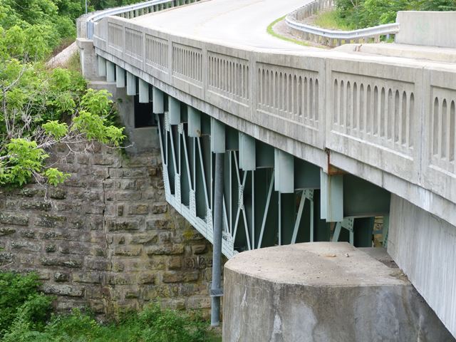
This bridge is very hard to photograph with leaves on the trees. The bridge is an uncommon example of a small-scale deck truss. Deck truss bridges tend to be reserved for longer spans over deep valleys. This bridge is neither. It rests on stone abutments that are presumably from a previous bridge. The pier is concrete. The bridge's trusses are heavy, yet the bracing for the bridge is quite lightweight as shown in the photo to the right. The bridge includes a concrete t-beam approach span which crosses over a railroad line that parallels the creek. The truss span passes over the creek. The bridge was built with the two spans slightly at an angle to each other, allowing the bridge to support a slightly curved roadway.

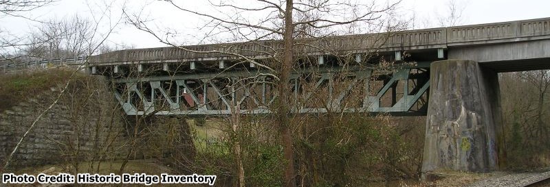
Information and Findings From Ohio's Historic Bridge InventorySetting/Context The bridge carries a 2 lane road over a stream in a sparsely developed, rural setting. Physical Description The 2 span bridge has a 100'-long, rivet-connected Pratt deck truss main span and a T beam approach span. The truss is traditionally composed of built-up members. It is supported on ashlar abutments and a concrete pier. Integrity Rehabilitated in 1990. Deck and railings replaced. Original concrete balustrades replaced with safety-shape barriers with exterior faced textured to appear like balustrades. Summary of Significance The 1928 Pratt deck truss bridge was rehabilitated with a finding of no adverse effect in 1989-90. It is eligible from the prior inventory. Justification The bridge is 1 of 9 riveted Pratt trusses in the study population dating from the first half of the 20th century. Its level of significance is moderate. Bridge Considered Historic By Survey: Yes |
![]()
![]()
![]()
Coordinates (Latitude, Longitude):
Search For Additional Bridge Listings:
Bridgehunter.com: View listed bridges within 0.5 miles (0.8 kilometers) of this bridge.
Bridgehunter.com: View listed bridges within 10 miles (16 kilometers) of this bridge.
Additional Maps:
Google Streetview (If Available)
GeoHack (Additional Links and Coordinates)
Apple Maps (Via DuckDuckGo Search)
Apple Maps (Apple devices only)
Android: Open Location In Your Map or GPS App
Flickr Gallery (Find Nearby Photos)
Wikimedia Commons (Find Nearby Photos)
Directions Via Sygic For Android
Directions Via Sygic For iOS and Android Dolphin Browser
USGS National Map (United States Only)
Historical USGS Topo Maps (United States Only)
Historic Aerials (United States Only)
CalTopo Maps (United States Only)

© Copyright 2003-2024, HistoricBridges.org. All Rights Reserved. Disclaimer: HistoricBridges.org is a volunteer group of private citizens. HistoricBridges.org is NOT a government agency, does not represent or work with any governmental agencies, nor is it in any way associated with any government agency or any non-profit organization. While we strive for accuracy in our factual content, HistoricBridges.org offers no guarantee of accuracy. Information is provided "as is" without warranty of any kind, either expressed or implied. Information could include technical inaccuracies or errors of omission. Opinions and commentary are the opinions of the respective HistoricBridges.org member who made them and do not necessarily represent the views of anyone else, including any outside photographers whose images may appear on the page in which the commentary appears. HistoricBridges.org does not bear any responsibility for any consequences resulting from the use of this or any other HistoricBridges.org information. Owners and users of bridges have the responsibility of correctly following all applicable laws, rules, and regulations, regardless of any HistoricBridges.org information.
![]()