

View Information About HSR Ratings
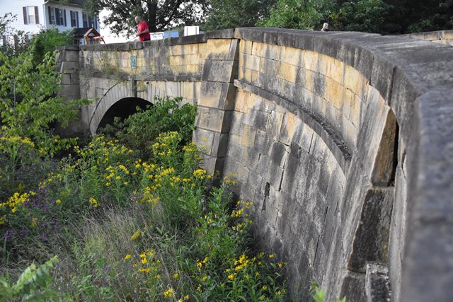
This impressive stone arch "S" bridge has been closed to traffic but remains open to pedestrians and is a National Historic Landmark. Length given is as shown in the National Bridge Inventory. The overall length including the long curved abutments is estimated at 212 feet.

Above: Historical photo of bridge.
Information and Findings From Ohio's Historic Bridge InventorySetting/Context The bridge carries a 2 lane road over a stream in a rural setting adjacent to a period house. IR 70 is to the south. This is the Old National Road. Physical Description The 1 span, 55'-long, stone arch bridge is built on an "S" plan with approaches that curve to achieve a right-angle crossing of the stream. It has coursed ashlar arch barrel, spandrel walls, and parapets. The arch ring has voussoirs and keystone. There are buttresses at the abutment corners. Integrity Rehabilitated, 2005. Displacement of the wingwalls and vegetation growing into masonry at north end of bridge (2009). Summary of Significance The "S" bridge was built in 1828 as part of the Old National Road. It is NR listed (1966). Stone arch highway bridges and culverts are not uncommon in Ohio with more than 190 examples dating from ca. 1825 to 1940 (Phase 1A Survey, 2008). Significant examples date to the 2nd quarter of the 19th century (fewer than 26 pre-1851) and are often associated with historically important transportation routes such as the National Road and the state's early canals or railroads. Later examples may have significance on the merits of the aesthetic quality/craftsmanship of the masonry work or in association with parks, such as the stone arch bridges in Cleveland's Rockefeller Park (ca. 1897-1904) or Youngstown's Mill Creek Park (ca. 1913). Stone arch culverts have roadways on earth fill atop the arch, which may or may not have headwalls, but they are the same traditional technology as arch bridges that have spandrel walls and parapets. "The immigrants who settled America came from European countries where masonry arch bridge construction was well established. Our most distinctive collection of stone arch bridges are found on the early, eastern trunkline railroads such as the B&O and Erie railroads. Early turnpikes such as the National Road had impressive stone arch bridges in Maryland. Along the road in Ohio, the famous S-bridges were built. Canals such as the Erie and the Chesapeake & Ohio had stone arch aqueducts. The technology of stone arch construction is ancient. Increased use of metal truss bridges from the late 1800s into the early twentieth century, led to a decline in stone arch bridge construction. The strength and durability of stone arch bridges made them popular. Generally, stone arch bridges built during the nineteenth century are found today in areas where good stone was available. Stone arches were common in the first half of the nineteenth century, and a number of these structures still exist. Stone arch bridges from the late eighteenth and first half of the nineteenth century are highly significant if they retain their character-defining features, which include the arch ring with keystone, barrel, spandrel wall, parapet, headwalls and abutments/wingwalls. Piers may also be a character-defining feature. Many of these stone arch structures possess both engineering and historical significance for their associations with the work programs of the Great 1930s. Stone arch bridges that do not fit within these areas (early, Depression-era, association with parks) generally possess less significance, but are still significant." [From: A Context for Common Historic Bridge Types by Parsons Brinckerhoff, October 2005] Justification A well represented bridge type throughout the state for both bridges and culverts, stone arch bridges date from the late 1820s and the building of the National Road through Belmont Co. Many are superbly proportioned and constructed by local contractors. They were used through World War I, particularly during the later years in park settings. More than 125 examples remain. This example has high significance based on its date of construction, detailing, and historic contexts) with the National Road. Bridge Considered Historic By Survey: Yes |
![]()
![]()
![]()
Coordinates (Latitude, Longitude):
Search For Additional Bridge Listings:
Bridgehunter.com: View listed bridges within 0.5 miles (0.8 kilometers) of this bridge.
Bridgehunter.com: View listed bridges within 10 miles (16 kilometers) of this bridge.
Additional Maps:
Google Streetview (If Available)
GeoHack (Additional Links and Coordinates)
Apple Maps (Via DuckDuckGo Search)
Apple Maps (Apple devices only)
Android: Open Location In Your Map or GPS App
Flickr Gallery (Find Nearby Photos)
Wikimedia Commons (Find Nearby Photos)
Directions Via Sygic For Android
Directions Via Sygic For iOS and Android Dolphin Browser
USGS National Map (United States Only)
Historical USGS Topo Maps (United States Only)
Historic Aerials (United States Only)
CalTopo Maps (United States Only)

© Copyright 2003-2024, HistoricBridges.org. All Rights Reserved. Disclaimer: HistoricBridges.org is a volunteer group of private citizens. HistoricBridges.org is NOT a government agency, does not represent or work with any governmental agencies, nor is it in any way associated with any government agency or any non-profit organization. While we strive for accuracy in our factual content, HistoricBridges.org offers no guarantee of accuracy. Information is provided "as is" without warranty of any kind, either expressed or implied. Information could include technical inaccuracies or errors of omission. Opinions and commentary are the opinions of the respective HistoricBridges.org member who made them and do not necessarily represent the views of anyone else, including any outside photographers whose images may appear on the page in which the commentary appears. HistoricBridges.org does not bear any responsibility for any consequences resulting from the use of this or any other HistoricBridges.org information. Owners and users of bridges have the responsibility of correctly following all applicable laws, rules, and regulations, regardless of any HistoricBridges.org information.
![]()