

View Information About HSR Ratings
Note: The span length given is the clear span for the bascule. The total length given is an estimate for this segment of bridge, noted as "Bridge 66" in a historical article. The rest of the crossing of the bay is mostly fill, but with three additonal gaps where additional fixed spans are located. These are considered separate bridges and not taken into account with the span count or length. The actual length across the bay including the fill causeways is roughly estimated at 1.17 miles.
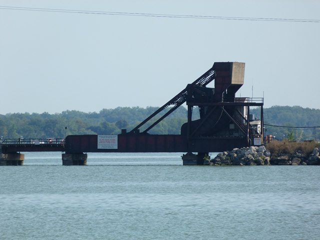
This bridge is difficult to get close to without a boat. The old causeway for a demolished highway bridge, now used as a fishing pier, are the easiest way for land lovers to view the bridge. The bridge appears to be a traditionally composed plate girder Scherzer type rolling lift bascule bridge. It is not known if Scherzer Rolling Lift Bridge Company was involved with this bridge; examples of rolling lift bridges not associated with Scherzer following this design have been identified. The bridge is on a long causeway. The causeway itself contains four separate "bridges." Three of them are composed of fixed spans that appear to be steel stringer spans. The fourth is this bascule bridge which also includes seven approach spans similar to the spans on the other bridges.
![]()
![]()
![]()
Coordinates (Latitude, Longitude):
Search For Additional Bridge Listings:
Bridgehunter.com: View listed bridges within 0.5 miles (0.8 kilometers) of this bridge.
Bridgehunter.com: View listed bridges within 10 miles (16 kilometers) of this bridge.
Additional Maps:
Google Streetview (If Available)
GeoHack (Additional Links and Coordinates)
Apple Maps (Via DuckDuckGo Search)
Apple Maps (Apple devices only)
Android: Open Location In Your Map or GPS App
Flickr Gallery (Find Nearby Photos)
Wikimedia Commons (Find Nearby Photos)
Directions Via Sygic For Android
Directions Via Sygic For iOS and Android Dolphin Browser
USGS National Map (United States Only)
Historical USGS Topo Maps (United States Only)
Historic Aerials (United States Only)
CalTopo Maps (United States Only)

© Copyright 2003-2025, HistoricBridges.org. All Rights Reserved. Disclaimer: HistoricBridges.org is a volunteer group of private citizens. HistoricBridges.org is NOT a government agency, does not represent or work with any governmental agencies, nor is it in any way associated with any government agency or any non-profit organization. While we strive for accuracy in our factual content, HistoricBridges.org offers no guarantee of accuracy. Information is provided "as is" without warranty of any kind, either expressed or implied. Information could include technical inaccuracies or errors of omission. Opinions and commentary are the opinions of the respective HistoricBridges.org member who made them and do not necessarily represent the views of anyone else, including any outside photographers whose images may appear on the page in which the commentary appears. HistoricBridges.org does not bear any responsibility for any consequences resulting from the use of this or any other HistoricBridges.org information. Owners and users of bridges have the responsibility of correctly following all applicable laws, rules, and regulations, regardless of any HistoricBridges.org information.
![]()