

View Information About HSR Ratings
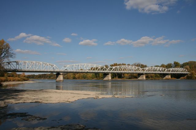
With a 1948 construction date, this is a relatively late example of a riveted truss bridge, however the bridge remains very important locally and regionally since it is the largest highway truss bridge in northwestern Ohio. A long, multi-span structure, the bridge is highly attractive because of its size. The bridge lacks v-lacing and lattice except for lattice under the top chord and end post on account of its large number of rolled beams versus built-up beams, which does give it a more plain appearance than other older truss bridges which often had much more built-up beams than this bridge has. However, the bridge makes up for this because of its size, which makes driving across it a very enjoyable experience with a strong "tunnel effect" as it might be called. In addition, the elevation views of this bridge on a sunny day as pictured above are spectacular!
The bridge is built to a Ohio state standard bridge plan.
A major alteration occurred when this bridge's bracing was cut and reconfigured to increase vertical clearance on the bridge.
Although there is some concrete portions as well on the abutments, the overall substructure of this bridge is stone.
This bridge is at risk for demolition and replacement. Although a somewhat late example of its type, Ohio has very few surviving examples of state standard plan truss bridges. As the name implies, state standard trusses were the design of the state in which they were built, and the design details are therefore unique to that state. Therefore, if one state were to demolish all of its state standard truss bridges a historian could not look to other states to find identical design bridges. Therefore it is essential that Ohio preserve some of its state standard plans to prevent an loss of particular portion of transportation heritage.
Information and Findings From Ohio's Historic Bridge InventorySetting/Context
The bridge carries a 2 lane road over a stream in a rural setting with scattered 20th century development. The town of Waterville is beyond the west end of the bridge. The prior truss bridge at this location collapsed in 1941 (see photo on old bridge card) [Shown to Right]. Physical Description The 5-span, 846'-long, rivet-connected Parker thru truss bridge is traditionally composed of built-up chords. Some of the diagonals are rolled sections. There are cantilevered sidewalks. The bridge is supported on the ashlar piers and abutments of the prior bridge at this location. The old substructure was widened with concrete. Integrity Deck replacement/repairs, 1988. Summary of Significance The 5-span, Parker thru truss bridge was built in 1948 by the state highway department. It is a late example of what was by 1948 a very common bridge type and design. The bridge is traditionally composed and
exhibits no innovative or distinctive details. Because it is a common solution to a long-span crossing, neither the bridge nor its contexts are historically or technologically significant. It is representative of a bridge type and
design as well as methods of fabrication that had been used for span lengths greater than 100' since the last quarter of the 19th century. Bridge Considered Historic By Survey: No |
This bridge is tagged with the following special condition(s): Unorganized Photos
![]()
![]()
![]()

![]()
![]()
This historic bridge has been demolished. This map is shown for reference purposes only.
Coordinates (Latitude, Longitude):
Search For Additional Bridge Listings:
Bridgehunter.com: View listed bridges within 0.5 miles (0.8 kilometers) of this bridge.
Bridgehunter.com: View listed bridges within 10 miles (16 kilometers) of this bridge.
Additional Maps:
Google Streetview (If Available)
GeoHack (Additional Links and Coordinates)
Apple Maps (Via DuckDuckGo Search)
Apple Maps (Apple devices only)
Android: Open Location In Your Map or GPS App
Flickr Gallery (Find Nearby Photos)
Wikimedia Commons (Find Nearby Photos)
Directions Via Sygic For Android
Directions Via Sygic For iOS and Android Dolphin Browser
USGS National Map (United States Only)
Historical USGS Topo Maps (United States Only)
Historic Aerials (United States Only)
CalTopo Maps (United States Only)

© Copyright 2003-2025, HistoricBridges.org. All Rights Reserved. Disclaimer: HistoricBridges.org is a volunteer group of private citizens. HistoricBridges.org is NOT a government agency, does not represent or work with any governmental agencies, nor is it in any way associated with any government agency or any non-profit organization. While we strive for accuracy in our factual content, HistoricBridges.org offers no guarantee of accuracy. Information is provided "as is" without warranty of any kind, either expressed or implied. Information could include technical inaccuracies or errors of omission. Opinions and commentary are the opinions of the respective HistoricBridges.org member who made them and do not necessarily represent the views of anyone else, including any outside photographers whose images may appear on the page in which the commentary appears. HistoricBridges.org does not bear any responsibility for any consequences resulting from the use of this or any other HistoricBridges.org information. Owners and users of bridges have the responsibility of correctly following all applicable laws, rules, and regulations, regardless of any HistoricBridges.org information.
![]()
