

View Information About HSR Ratings

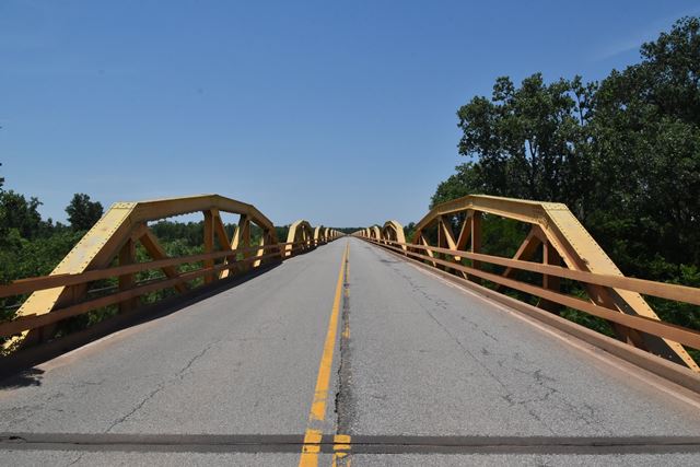
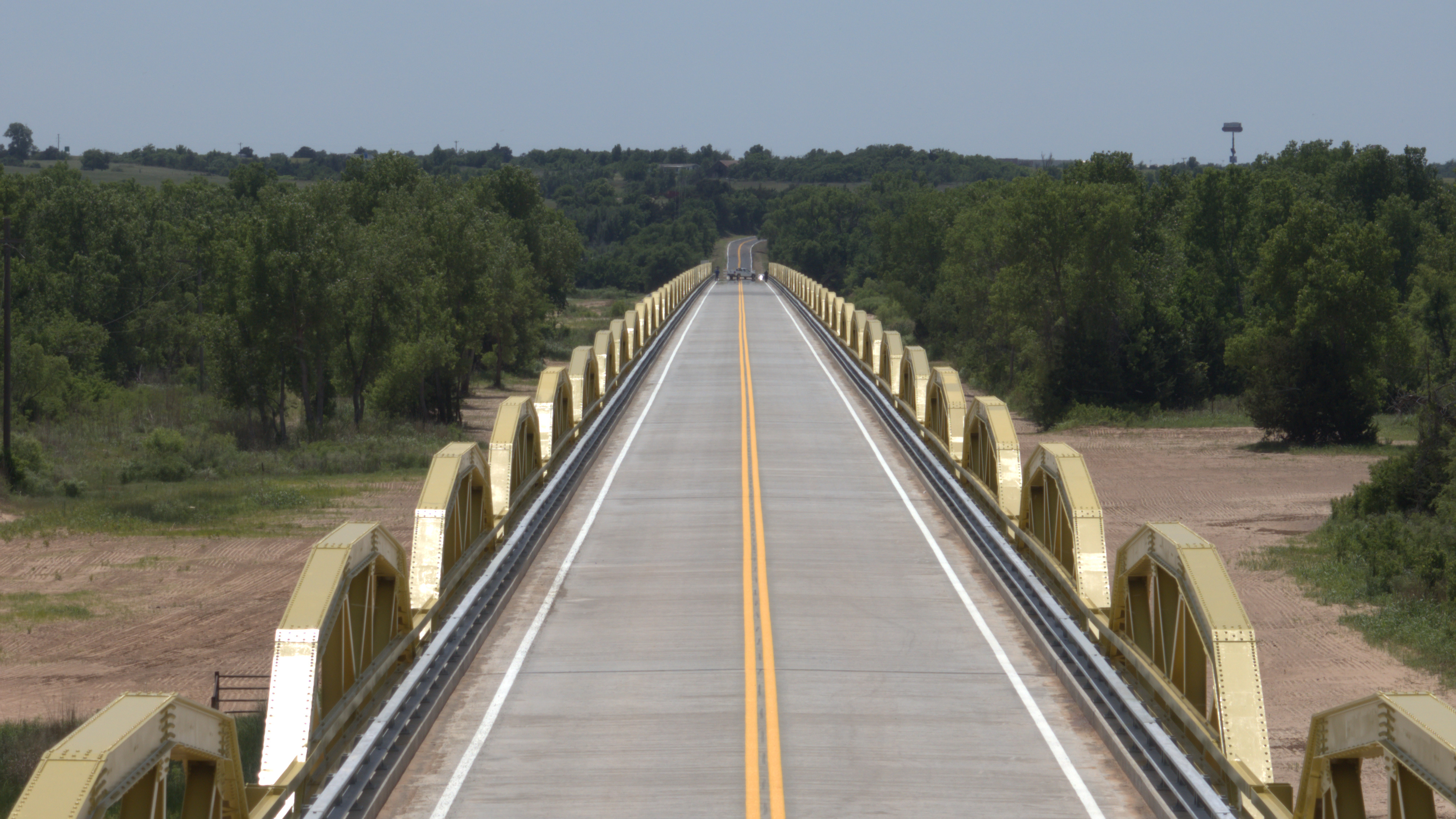
This bridge was suggested by Oklahoma Department of Transportation to be the most historically significant bridge in the state. It is hard to disagree. Oklahoma does not have the notable old 19th century cast and wrought iron truss bridges of states in the eastern United States. However, it has two unusual truss bridge forms that are unique to the state. The state is noted for its use of through truss bridges that utilize unique K-Parker truss configurations. The state is also noted for its extremely long simple-span truss bridges, most of which are created from state-standard pony truss spans. Of those ultra-long pony truss bridges, this bridge is by far the longest example and the best example. It has been reported to be the longest bridge of any kind in Oklahoma.
This bridge is so long in fact that HistoricBridges.org strongly believes it to be the longest simple-span pony truss in the entire country, both in terms of number of pony truss spans (38) and total spanning length of those 38 pony truss spans (3,800 total spanned feet by pony trusses). The overall length of the bridge as reported on the bridge plaque is 3,944.33 feet, which includes two 36 foot steel stringer approach spans. The Oklahoma bridge inventory system lists the overall length at 3,937.0 feet. A search on www.bridgehunter.com fails to reveal a single pony truss bridge with an overall length that even meets the 3,800 length. Because this bridge is apparantly the longest simple-span pony truss in America, the bridge should be considered nationally significant.
To create a context of how long this bridge is, consider that this bridge would extend (a small amount) beyond the main towers of the enormous Mackinac Bridge, which has a span of exactly 3,800 feet between towers. The bridge is longer than the overall length (3239 feet) of the massive Quebec Bridge in Canada.
The bridge is so long that in the hot Oklahoma sun, a mirage renders a clear photo of the entire bridge physically impossible as shown in the photo below. Driving across the bridge is a truly unique experience as the bridge which appears almost infinitely long as you approach it, feels like it keeps going on and on as one truss span after another rises over the roadway. HistoricBridges.org has attempted to record this experience through GoPro videos available on this page.

The bridge is also significant as one of the largest and most notable bridges on Historic Route 66. The bridge contributes to the historic significance of Route 66, and is a contributing structure to the National Register District, Bridgeport Hill - Hydro Route 66 Segment. It is worth noting that there is some nice looking vintage concrete roadway leading up to this bridge.

As of 2024, this bridge has been altered, as part of a compromise solution to avoid the outright demolition and replacement of the historic bridge. The compromise involved building a new bridge with a wider roadway, but retaining the truss lines as decorative elements positioned outside the new bridge beams. The intent was to allow the new bridge to still convey the original feeling of crossing a unique pony truss bridge, and to also retain the original materials of the most significant portion of the historic bridge, that of the truss webs. In addition, the piers for the new bridge visually resemble the original piers for the historic bridge. Obviously, while it would have been preferred to see the historic truss bridge rehabiliated in its original form, this bridge is also a good example of how the all-too-frequent outcome of total demolition and replacement with a slab of concrete can be avoided by way of compromise. In this compromise the most prominient visual feature (and one of the most important engineered and fabricated parts) of the historic bridge remains, and the general feel of crossing a pony truss bridge is still simulated for people traveling Historic Route 66.

Above: View of new bridge. Photo Credit: Oklahoma Department of Transportation
Above: View of new bridge. Photo Credit: Oklahoma Department of Transportation

Above: View of new bridge. Photo Credit: Oklahoma Department of Transportation
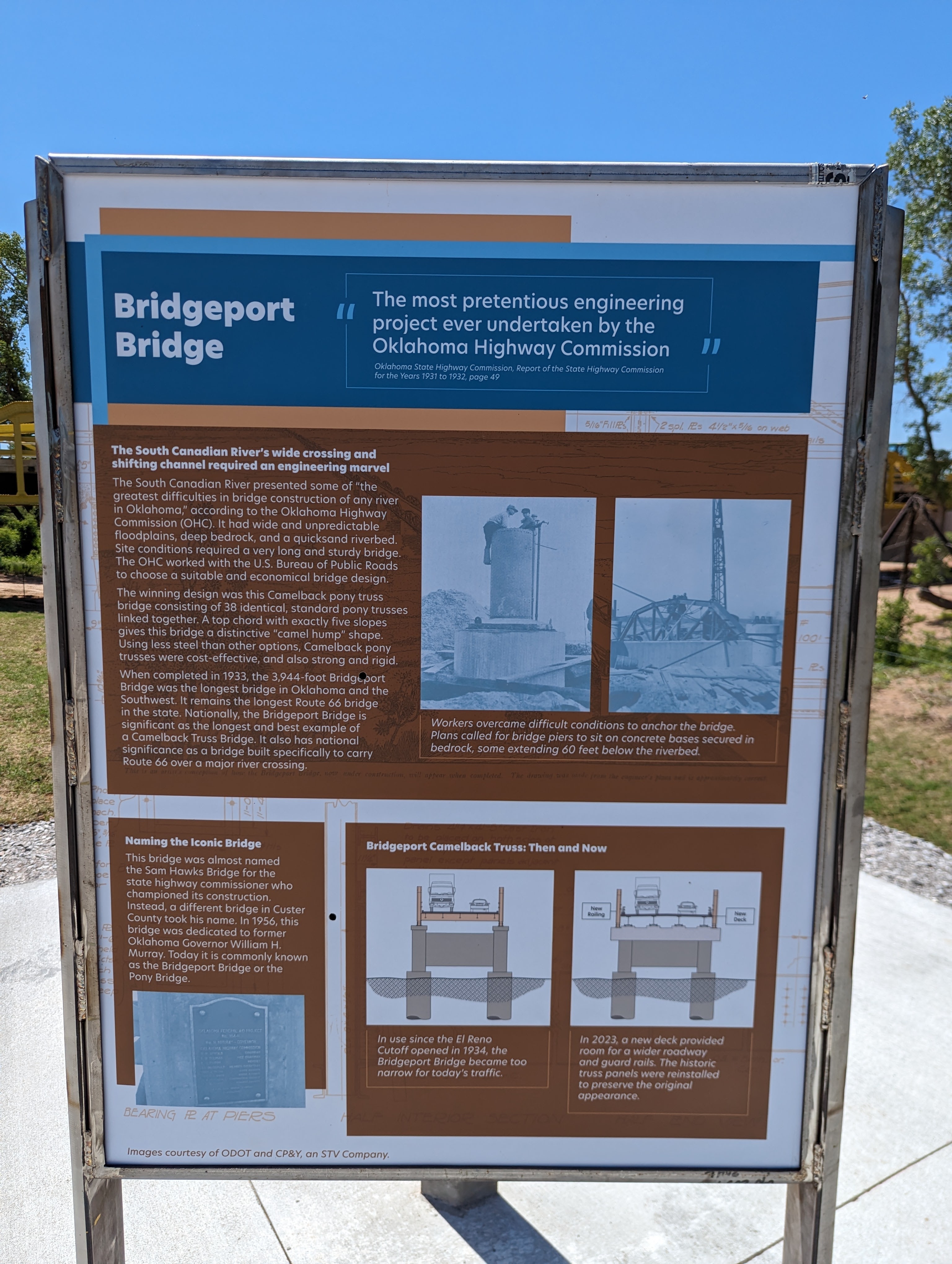
Above: Interpretive signage. Photo Credit: Russell Teague

Above: Interpretive signage. Photo Credit: Russell Teague

Above: View beside new bridge. Photo Credit: Russell Teague
![]()
![]()
![]()

![]()
![]()
Coordinates (Latitude, Longitude):
Search For Additional Bridge Listings:
Bridgehunter.com: View listed bridges within 0.5 miles (0.8 kilometers) of this bridge.
Bridgehunter.com: View listed bridges within 10 miles (16 kilometers) of this bridge.
Additional Maps:
Google Streetview (If Available)
GeoHack (Additional Links and Coordinates)
Apple Maps (Via DuckDuckGo Search)
Apple Maps (Apple devices only)
Android: Open Location In Your Map or GPS App
Flickr Gallery (Find Nearby Photos)
Wikimedia Commons (Find Nearby Photos)
Directions Via Sygic For Android
Directions Via Sygic For iOS and Android Dolphin Browser
USGS National Map (United States Only)
Historical USGS Topo Maps (United States Only)
Historic Aerials (United States Only)
CalTopo Maps (United States Only)

© Copyright 2003-2026, HistoricBridges.org. All Rights Reserved. Disclaimer: HistoricBridges.org is a volunteer group of private citizens. HistoricBridges.org is NOT a government agency, does not represent or work with any governmental agencies, nor is it in any way associated with any government agency or any non-profit organization. While we strive for accuracy in our factual content, HistoricBridges.org offers no guarantee of accuracy. Information is provided "as is" without warranty of any kind, either expressed or implied. Information could include technical inaccuracies or errors of omission. Opinions and commentary are the opinions of the respective HistoricBridges.org member who made them and do not necessarily represent the views of anyone else, including any outside photographers whose images may appear on the page in which the commentary appears. HistoricBridges.org does not bear any responsibility for any consequences resulting from the use of this or any other HistoricBridges.org information. Owners and users of bridges have the responsibility of correctly following all applicable laws, rules, and regulations, regardless of any HistoricBridges.org information.
![]()