

View Information About HSR Ratings
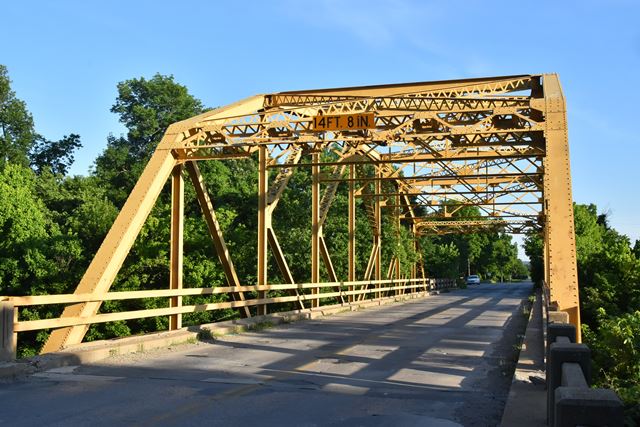
This bridge is an excellent and increasingly rare surviving example of a signature Oklahoma K-Parker truss bridge. The design was a standard in Oklahoma, but nationwide, K-truss designs are one of the rarest truss designs to be found.
This bridge was slated for replacement, but the effort to find a third party to take ownership of this bridge and relocate it to a new location was successful. The photos on this website were taken prior to relocation. At the end of 2017, the bridge made its move. Today, the bridge has moved about three miles due south onto private property, although the bridge should remain visible to the public as the new location is close to the public highway. Of note, the bridge was moved intact, which is an impressive feat because all overhead utilities in the way had to be moved out of the way to move this enormous bridge down the road. It is more common for bridges of this size to be dismantled and shipped by truck for this reason. The fact that it moved due south on a straight road may have helped make moving this bridge intact more feasible.
![]()
![]()
![]()

![]()
This bridge was previously located at 36.31571, -95.99149. Current location is private property, but viewable from public highway OK-11.
Coordinates (Latitude, Longitude):
Search For Additional Bridge Listings:
Bridgehunter.com: View listed bridges within 0.5 miles (0.8 kilometers) of this bridge.
Bridgehunter.com: View listed bridges within 10 miles (16 kilometers) of this bridge.
Additional Maps:
Google Streetview (If Available)
GeoHack (Additional Links and Coordinates)
Apple Maps (Via DuckDuckGo Search)
Apple Maps (Apple devices only)
Android: Open Location In Your Map or GPS App
Flickr Gallery (Find Nearby Photos)
Wikimedia Commons (Find Nearby Photos)
Directions Via Sygic For Android
Directions Via Sygic For iOS and Android Dolphin Browser
USGS National Map (United States Only)
Historical USGS Topo Maps (United States Only)
Historic Aerials (United States Only)
CalTopo Maps (United States Only)

© Copyright 2003-2024, HistoricBridges.org. All Rights Reserved. Disclaimer: HistoricBridges.org is a volunteer group of private citizens. HistoricBridges.org is NOT a government agency, does not represent or work with any governmental agencies, nor is it in any way associated with any government agency or any non-profit organization. While we strive for accuracy in our factual content, HistoricBridges.org offers no guarantee of accuracy. Information is provided "as is" without warranty of any kind, either expressed or implied. Information could include technical inaccuracies or errors of omission. Opinions and commentary are the opinions of the respective HistoricBridges.org member who made them and do not necessarily represent the views of anyone else, including any outside photographers whose images may appear on the page in which the commentary appears. HistoricBridges.org does not bear any responsibility for any consequences resulting from the use of this or any other HistoricBridges.org information. Owners and users of bridges have the responsibility of correctly following all applicable laws, rules, and regulations, regardless of any HistoricBridges.org information.
![]()