


View Information About HSR Ratings
Information from Ontario Bridge Inventory: Span lengths: 13.7 meters, 24.4 meters, 13.7 meters. Bridge width: 15.5 meters.
This bridge is an impressive concrete arch bridge. It was originally built to carry Longwood Road. Later in the 1960s, the bridge was incorporated into the King's Highway 403 which was built over the canal, which also brought an end to Longwood Road crossing the canal. To accommodate the expressway a second bridge was built next to the arch bridge. The second bridge carries westbound KH-403 traffic, while the arch bridge carries eastbound KH-403 traffic.
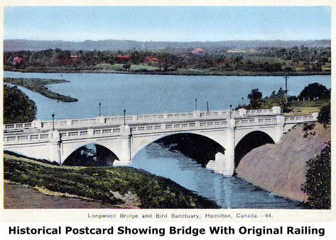
This bridge is a rare example of a closed spandrel arch bridge that has a ribbed design. Rather than a single, solid arch ring with fill on top where the deck can rest, the ribbed design is similar to that used more commonly on open spandrel arch bridges, where each arched rib extends up to support the deck. The bridge has a large central span that crosses the canal and one shorter arch span at each end. The arches have a graceful appearance and have modest architectural details. The arches, piers, and abutments all appear to retain good historic integrity with no major alterations noted. However, this bridge's original ornate concrete railings with a lattice-like design on them were removed and replaced with typical, ugly modern concrete barrier. The postcard to the right shows the bridge with its original railing. After viewing the postcard and comparing it to the bridge as seen today is is surprising how devastating the loss of the original railings was to the beauty of this bridge. The bridge looks quite plain compared to what it looked like with the original railing on it.
Despite alteration, this bridge remains a noteworthy, technologically significant heritage bridge.
This bridge is located at an area that has been home to many bridges, some of which remain standing today, some of which no longer remain. Three of the bridges remaining today, including the Longwood Bridge have heritage value. The Longwood Bridge was built just prior to the construction of the current High Level Bridge, and helped serve as a detour during that bridge's construction. The High Level Bridge crosses over the third heritage bridge, the Desjardins Canal Railway Bridge, which passes under the bridge at an angle. This railway bridge is older than the current High Level Bridge.
![]()
![]()
![]()
This historic bridge has been demolished. This map is shown for reference purposes only.
Coordinates (Latitude, Longitude):
Search For Additional Bridge Listings:
Additional Maps:
Google Streetview (If Available)
GeoHack (Additional Links and Coordinates)
Apple Maps (Via DuckDuckGo Search)
Apple Maps (Apple devices only)
Android: Open Location In Your Map or GPS App
Flickr Gallery (Find Nearby Photos)
Wikimedia Commons (Find Nearby Photos)
Directions Via Sygic For Android
Directions Via Sygic For iOS and Android Dolphin Browser

© Copyright 2003-2026, HistoricBridges.org. All Rights Reserved. Disclaimer: HistoricBridges.org is a volunteer group of private citizens. HistoricBridges.org is NOT a government agency, does not represent or work with any governmental agencies, nor is it in any way associated with any government agency or any non-profit organization. While we strive for accuracy in our factual content, HistoricBridges.org offers no guarantee of accuracy. Information is provided "as is" without warranty of any kind, either expressed or implied. Information could include technical inaccuracies or errors of omission. Opinions and commentary are the opinions of the respective HistoricBridges.org member who made them and do not necessarily represent the views of anyone else, including any outside photographers whose images may appear on the page in which the commentary appears. HistoricBridges.org does not bear any responsibility for any consequences resulting from the use of this or any other HistoricBridges.org information. Owners and users of bridges have the responsibility of correctly following all applicable laws, rules, and regulations, regardless of any HistoricBridges.org information.
![]()