

View Information About HSR Ratings

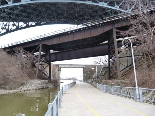
This bridge was constructed ca. 1897 to pass over the canal while at the same time passing under the previous High Level Bridge, a steel arch bridge which no longer exists today and has been replaced by the current High Level Bridge which also passes over this railway bridge. The bridge is supported by steel bents. Due to the steep slope of the terrain where the bents rest, the bracing between the bottom of the bents runs at an unusual angle. The bridge's center span is a variable depth girder which adds variety to the design of the superstructure. Built ca. 1897, this bridge is an early surviving example of a plate girder bridge in Ontario.
This bridge is located at an area that has been home to many bridges, some of which remain standing today, some of which no longer remain. Three of the bridges remaining today, including this railway bridge, have heritage value. One interesting feature of the railway bridge is it actually crosses over another heritage bridge, the High Level Bridge, which passes under the bridge at an angle. The third heritage bridge is the nearby low level Longwood Bridge, a concrete arch bridge that was built just prior to the construction of the current High Level Bridge, and helped serve as a detour during its construction. Immediately to the right of the heritage railway bridge is a modern plate girder bridge that adds a third set of tracks beyond the two tracks that the heritage bridge's deck provides. To the right of the modern plate girder are stone abutments. These are from an 1870 pin-connected metal through truss bridge that was built to serve a toll road. The construction of the heritage railway bridge and its approaching trackage in 1897 required buying the toll road and the construction of the railway bridge cut off the toll road turning the 1870 bridge into a bridge to nowhere. This bridge was later removed, but was still standing as late as 1913 when the historical photo seen on this page was taken. At the far eastern end of the canal are two large, old stone abutments from 1859 that today support an ugly, modern pre-stressed box beam bridge that is already leaking and drips water onto pedestrians walking on the trail that runs along the canal.

![]()
![]()
![]()
Coordinates (Latitude, Longitude):
Search For Additional Bridge Listings:
Additional Maps:
Google Streetview (If Available)
GeoHack (Additional Links and Coordinates)
Apple Maps (Via DuckDuckGo Search)
Apple Maps (Apple devices only)
Android: Open Location In Your Map or GPS App
Flickr Gallery (Find Nearby Photos)
Wikimedia Commons (Find Nearby Photos)
Directions Via Sygic For Android
Directions Via Sygic For iOS and Android Dolphin Browser

© Copyright 2003-2024, HistoricBridges.org. All Rights Reserved. Disclaimer: HistoricBridges.org is a volunteer group of private citizens. HistoricBridges.org is NOT a government agency, does not represent or work with any governmental agencies, nor is it in any way associated with any government agency or any non-profit organization. While we strive for accuracy in our factual content, HistoricBridges.org offers no guarantee of accuracy. Information is provided "as is" without warranty of any kind, either expressed or implied. Information could include technical inaccuracies or errors of omission. Opinions and commentary are the opinions of the respective HistoricBridges.org member who made them and do not necessarily represent the views of anyone else, including any outside photographers whose images may appear on the page in which the commentary appears. HistoricBridges.org does not bear any responsibility for any consequences resulting from the use of this or any other HistoricBridges.org information. Owners and users of bridges have the responsibility of correctly following all applicable laws, rules, and regulations, regardless of any HistoricBridges.org information.
![]()