

View Information About HSR Ratings

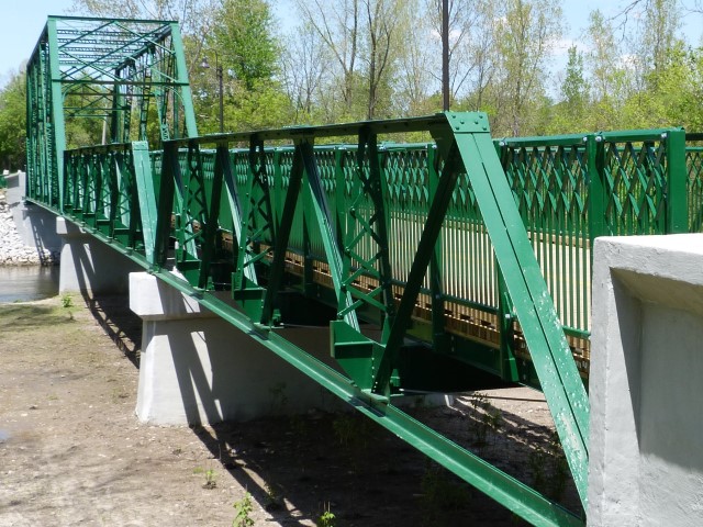
This bridge's through truss span utilizes the same truss configuration, as well as the overall design layout of the bridge as some other bridges in southwestern Ontario like the Cameron Road Bridge. It should be noted that despite multiple examples of this design in the area, the truss configuration present on these bridges, the double-intersection warren, is actually an unusual truss configuration. In addition, this bridge is noteworthy for having two pony truss approach spans at the southern end. Pony truss approach spans create a visually pleasing compliment to a through truss main span. Also, multi-span pony truss bridges are uncommon, although London has two other multi-span pony truss bridges.
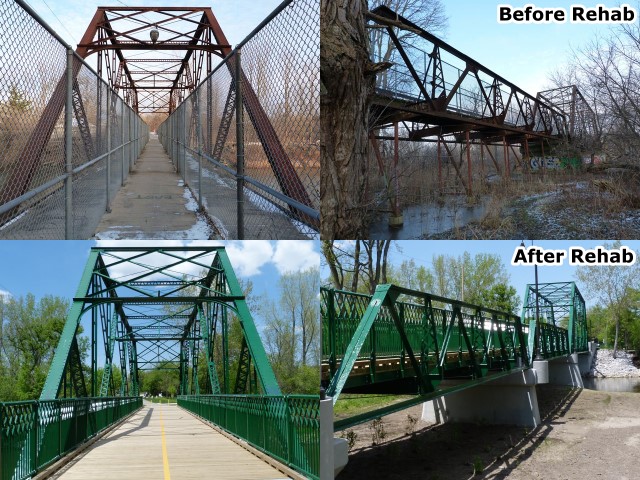
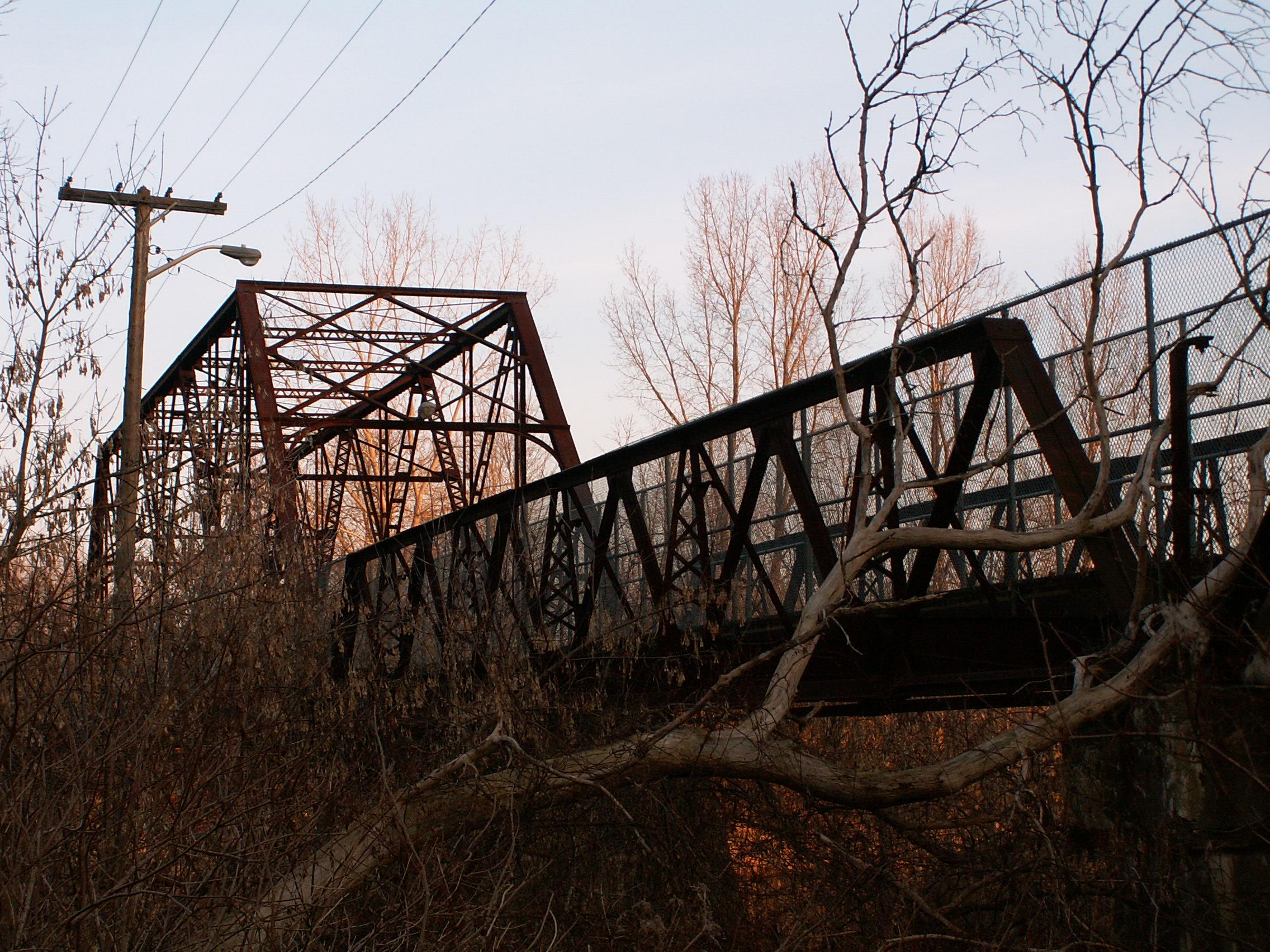
This bridge had been closed to vehicular traffic for many years, but left open for pedestrian use, but had developed severe deterioration especially in the pony truss spans. HistoricBridges.org has photo galleries showing the bridge prior to rehabilitation.
However the good news is in 2013, this bridge has thankfully been rehabilitated for continued pedestrian use! The previously unpainted bridge now has a coat of green paint on it. The narrow walkway with ugly cyclone fencing has been removed and new railing is in place allowing the full roadway of the bridge to be used by pedestrians. The deteriorated floor beams and bottom chord on the pony truss spans were replaced. Although a couple of the repairs were a bit odd looking like the apparent use of concrete rebar for replacement lower lateral bracing, and empty rivet holes where original pony truss outriggers were welded to the new bottom chord and floor beams, the overall rehabilitation has corrected the deficiencies of the bridge while maintaining the majority of the original bridge material. Especially given the poor condition of the bridge prior to rehabilitation this is a great success story. The bridge retains its heritage value and is now an attractive looking bridge, open and inviting for pedestrians.
A before and after comparison photo is shown below, as is a discussion of this bridge prior to rehabilitation.
John Lucas, Transportation Planning and Design Manager for London provided the following information on the bridge:
The bridge still stands after almost 100
years of service, but is in poor condition. It is maintained for pedestrian
usage only. A high chain link walkway was erected down the middle of the bridge
for safety reasons.
It consists of 3 spans over the South Branch of the Thames River. The north span
is a simply supported through-truss, with the top chords of the truss braced
across the roadway. This span accommodates, though constrains, river flows. The
central and south spans are "pony trusses" spanning the floodplain. The top
chords of these are situated about 6 feet above the deck level and are supported
by knee braces to the bottom chord. All spans use longitudinal steel stringers
over transverse floor beams to support an original 18 foot wide deck.
A thorough review of the bridge in 1990 revealed failure of stringers and floor
beams. The bridge was closed until it could be improved for pedestrian use only.
Today, many truss components suffer from a significant loss of section. The
concrete deck on the through truss is in poor condition, however the timber
decking on the two pony truss spans is in good condition. Foundations are
partially exposed and abutments have severe spalling in places. Given the
condition, it has been on our "replacement list" for many years. The low usage
does not make it a high priority.
This bridge is indeed in extremely poor condition, particularly with the floor beams. However, if both citizenry and government really were dedicated to preserving this impressive structure it could be done. Floor beams and bottom chord connections would likely require significant repairs, but as long as the main trusses were retained, the general historic integrity of the bridge could be maintained. London has an amazingly rich assortment of historic truss bridges, and this bridge contributes greatly to this collection of truss bridges. It certainly isn't as important as the Blackfriars Bridge, but it is still important and beautiful as well, and worthy of preservation. Restoration of this bridge would create an attractive park experience and focal point for this developing area in the city of London. Any costs associated with restoration would likely pay off in future years. As a pedestrian-only bridge, their would not be a need to get the bridge to support a high weight limit, so restoration would really only need to be limited to repairing the areas of the bridge with critical section loss.

This website considers any truss bridge older than 1970 to be historic because they utilize methods of construction no longer in use in modern construction. It is important to represent not only the rarest designs of old bridges, but also the more common ones. For in many senses, the more common bridges perhaps create a clearer picture of the period to which they date than the unusual bridges. This website views any old bridge that retains decent historic integrity to be historic at some level, even if a small one. For this reason, a wide variety of old bridges appear on the website, with a description of the bridge discussing the level of historic value each structure has. Under these statements, clearly the Meadowlily Road Bridge deserves a place on HistoricBridges.org. But is it possible to clearly describe the level of historic value that the bridge has... in other words, we can certainly say it "is" historic, but can we say "how" historic it is? A short discussion of this follows, along with a call to Canadians to ask their government to review their rich collection of historic bridges through a historic bridge inventory.
Consider the question: Is the Meadowlily Road Bridge historic? It does not appear in the Ontario Heritage Bridge List, and so one would assume that it is not, and indeed this bridge has been considered non-historic by its owner, the City of London. This website covers historic bridges in both the United States and Canada. In the United States, federal law mandates that all states conduct historic bridge inventories to review all bridges within the state and create a list of all bridges determined to be historic. In Canada, there does not appear to be such a requirement in place that mandates the evaluation of all bridges in the country. What is the result? In the United States, their may be an awareness of where all the old bridges in the country are located, but often the consulting engineers who perform these inventories only list a select few bridges as being historic, leaving others listed non-historic and unprotected from demolition. In Canada, it seems that agencies like the Ministry of Culture do not even know about the bridges in the first place. If the local counties, townships, or municipalities want to consider their bridges historic and preserve them, or consider them non-historic and demolish them, that is their own decision. Neither of these plans seems to work well. For one thing, how does one define "historic" as a descriptive value? In the United States, where government agencies and consulting engineers with no genuine interest in preservation are making the decisions, it would seem appropriate to suggest that their historic bridge lists are too conservative. In Canada, where it is unclear what the complete national, or even provincial inventory of old bridges looks like, it is actually impossible to determine the level of historic value that a bridge like the Meadowlily Bridge is. Without a complete list of bridges in Ontario, how can one determine whether the Meadowlily bridge is a rare multi-span truss bridge in Ontario. How many other multi-span truss bridges remain in Ontario? Although I have found two other truss bridges with a similar design to this one, is this trio of bridges the last of its kind or are there 20 more like it out there waiting to be found?
The answer to these questions could be found, if either at the national or provincial level, a historic bridge inventory were conducted. A historic bridge inventory consists of first making a list of all bridges in the province or country older than 50 years. Then, the bridges in the list are reviewed and researched and and evaluation of each bridge's significance is made. As a result, it would then be possible to see how rare a particular structure is, and thus make a decision on how much effort should be placed on preservation. In addition, the inventories can be used by people to aid in finding bridges to photograph. Currently the only way to get a complete list of old bridges for even a single county involves contacting a ton of people from counties, to MTO, to municipalities, down to even townships. A daunting task for an individual, but a task that government could certainly do.
The time has come to ask for a historic bridge inventory in Ontario, and hopefully all of Canada. With an inventory, locating historic bridges would be much easier, and also most likely, it would become much clearer how rare a bridge like the Meadowlily Bridge is, and perhaps its future would be a bit brighter.
![]()
![]()
![]()

![]()
![]()
![]()
Coordinates (Latitude, Longitude):
Search For Additional Bridge Listings:
Additional Maps:
Google Streetview (If Available)
GeoHack (Additional Links and Coordinates)
Apple Maps (Via DuckDuckGo Search)
Apple Maps (Apple devices only)
Android: Open Location In Your Map or GPS App
Flickr Gallery (Find Nearby Photos)
Wikimedia Commons (Find Nearby Photos)
Directions Via Sygic For Android
Directions Via Sygic For iOS and Android Dolphin Browser

© Copyright 2003-2026, HistoricBridges.org. All Rights Reserved. Disclaimer: HistoricBridges.org is a volunteer group of private citizens. HistoricBridges.org is NOT a government agency, does not represent or work with any governmental agencies, nor is it in any way associated with any government agency or any non-profit organization. While we strive for accuracy in our factual content, HistoricBridges.org offers no guarantee of accuracy. Information is provided "as is" without warranty of any kind, either expressed or implied. Information could include technical inaccuracies or errors of omission. Opinions and commentary are the opinions of the respective HistoricBridges.org member who made them and do not necessarily represent the views of anyone else, including any outside photographers whose images may appear on the page in which the commentary appears. HistoricBridges.org does not bear any responsibility for any consequences resulting from the use of this or any other HistoricBridges.org information. Owners and users of bridges have the responsibility of correctly following all applicable laws, rules, and regulations, regardless of any HistoricBridges.org information.
![]()