

View Information About HSR Ratings
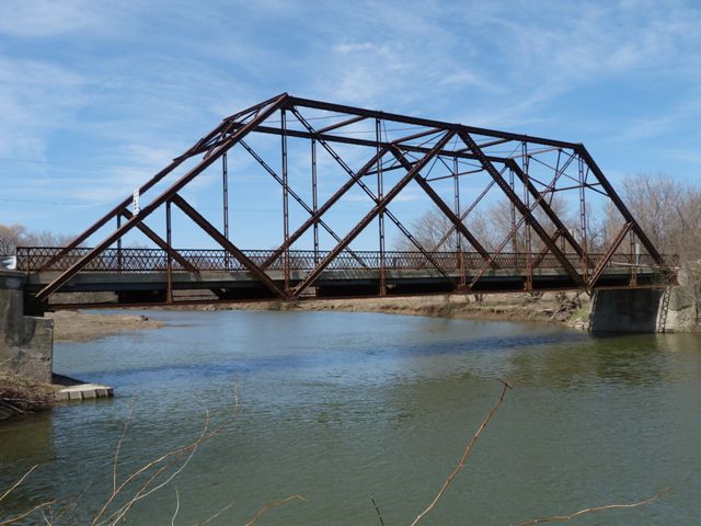
This bridge is built to a particular design and truss configuration that was built throughout Ontario and of which a small collection of examples still remain today to represent the design and the characteristics which define the group. Although the design is found on multiple bridges in Ontario, outside of Ontario the design of these bridges would be classified as extremely unusual and rare. Two elements make the design unusual. First, the truss configuration is a subdivided double-intersection Warren. This means that in addition to a vertical member between each "X" of diagonal members, there is also a vertical member that passes right through the center of each "X." Double-intersection Warrens are uncommon, but subdivided double-intersection Warren truss bridges are very unusual. The other unusual feature of these bridges is the shallow slope of the end post, which results in an unusually long endpost. As a result of this unusually long end post design, there is an additional vertical and diagonal member that connect to the endpost halfway up, and there is also a floorbeam under the vertical member.
The Blenheim Road Bridge is an excellent example of this type. It is of decent span length and it retains good historic integrity.
![]()
![]()
![]()

![]()
![]()
![]()
Coordinates (Latitude, Longitude):
Search For Additional Bridge Listings:
Additional Maps:
Google Streetview (If Available)
GeoHack (Additional Links and Coordinates)
Apple Maps (Via DuckDuckGo Search)
Apple Maps (Apple devices only)
Android: Open Location In Your Map or GPS App
Flickr Gallery (Find Nearby Photos)
Wikimedia Commons (Find Nearby Photos)
Directions Via Sygic For Android
Directions Via Sygic For iOS and Android Dolphin Browser

© Copyright 2003-2024, HistoricBridges.org. All Rights Reserved. Disclaimer: HistoricBridges.org is a volunteer group of private citizens. HistoricBridges.org is NOT a government agency, does not represent or work with any governmental agencies, nor is it in any way associated with any government agency or any non-profit organization. While we strive for accuracy in our factual content, HistoricBridges.org offers no guarantee of accuracy. Information is provided "as is" without warranty of any kind, either expressed or implied. Information could include technical inaccuracies or errors of omission. Opinions and commentary are the opinions of the respective HistoricBridges.org member who made them and do not necessarily represent the views of anyone else, including any outside photographers whose images may appear on the page in which the commentary appears. HistoricBridges.org does not bear any responsibility for any consequences resulting from the use of this or any other HistoricBridges.org information. Owners and users of bridges have the responsibility of correctly following all applicable laws, rules, and regulations, regardless of any HistoricBridges.org information.
![]()