

View Information About HSR Ratings
Originally known as the Cornwall-Massena International Bridge, this bridge is more recently known as the Seaway International Bridge. The border crossing this bridge provides was recently given the honorary name of Three Nations Crossing. The Seaway International Bridge is actually two distinct bridges that hop across an island in the St. Lawrence River. The bridges include the South Channel Bridge, and the North Channel Bridge. The two bridges are often referred to as a single bridge, but from an engineering standpoint they are clearly two bridges, and as such are represented by separate pages on HistoricBridges.org.
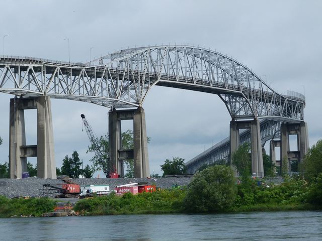
The North Channel Bridge is a large high level bridge that was built to provide a fixed bridge over a navigation canal, as well as cross over the non-navigable natural north channel of the St. Lawrence River. The high level design let things like Great Lakes freighters fit under the bridge, meaning that the height of the bridge was substantial. As such, the bridge features an extensive set of deck plate girder and deck truss approach spans to reach this height from the surrounding flat landscape. The haunched deck truss approach spans consist of segments of continuous spans, meaning for a few spans the bridge is continuous, then there is a break in the continuity followed by another series of continuous spans. The main span of the bridge is noteworthy for its arched truss design. This design was used for both cantilever and continuous bridges. This particular bridge does not have hinges or a suspended span, so functions as continuous, not a cantilever. The arched truss design is a rare, but beautiful truss variety. The arched truss span crosses over the navigation canal, while the natural North Channel is crossed by the approach deck truss spans south of the main spans. The overall bridge follows a weaving curve, adding to the complex appearance and design of the bridge.
The bridge was designed by the son of famous engineer Phillip Louis Pratley, who was Hugh H. L. Pratley.

This bridge has an unusual contemporary story. The North Channel canal ended up being abandoned. Subsequently, the section east of the bridge was filled in, with only a small drain existing east of the bridge today. Directly under the bridge and west of the bridge, the canal is still quite wide, however no longer navigable. This means that today, the bridge has a very unusual appearance, since it goes over a body of water that essentially dead ends a short distance east of the bridge. Also, it means that today, a short, small, low level bridge can cross what is left of the canal, and an average height and length bridge can cross the natural North Channel. Therefore, this heritage bridge has been replaced by just that, two separate low level bridges that carry traffic over these two bodies of water. These bridges were completed in January, 2014. The heritage bridge will be demolished with total project completion by 2016.

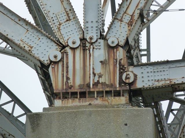
The existing heritage bridge's steel superstructure and concrete substructure appears to be in a good condition, and feasible to preserve. However, the deck is in very bad shape as anyone driving over the bridge can tell. Given that the cost of replacing the deck on a bridge that is so extremely long probably would cost as much as replacing the bridge with the two shorter low level bridges, it is easy to imagine that it would be hard to convince anyone to rehabilitate the heritage bridge. Nevertheless, the loss of this heritage bridge will have a devastating effect. Cornwall will no longer have a beautiful signature bridge and a rare bridge type will be destroyed. One solution that should have been considered would be to simply leave the bridge standing, either open to pedestrian traffic only, or even to remove the deck, and simply leave the bridge standing as a non-functional historical monument. These options would cost far less than demolishing the bridge.
This bridge is in a very unusual location. The bridge connects the Canadian mainland to an island south of the mainland. The island is Canadian soil, but is also part of an international Native American / First Nations reservation that extends south of the Canadian border into the United States. The residents of the island opposed the location of the Canadian customs in the traditional location on the island where the South Channel Bridge touches down on Canadian soil. Therefore, the customs were moved to north of the North Channel Bridge. This makes for an unusual situation. If someone is in Canada and goes to the island (also Canadian soil) they still have to go through Canadian customs to get back onto the mainland even though they never left Canada! This is a most unusual situation.


![]()
![]()
![]()
![]()
![]()

![]()
This historic bridge has been demolished. This map is shown for reference purposes only.
Coordinates (Latitude, Longitude):
Search For Additional Bridge Listings:
Additional Maps:
Google Streetview (If Available)
GeoHack (Additional Links and Coordinates)
Apple Maps (Via DuckDuckGo Search)
Apple Maps (Apple devices only)
Android: Open Location In Your Map or GPS App
Flickr Gallery (Find Nearby Photos)
Wikimedia Commons (Find Nearby Photos)
Directions Via Sygic For Android
Directions Via Sygic For iOS and Android Dolphin Browser

© Copyright 2003-2025, HistoricBridges.org. All Rights Reserved. Disclaimer: HistoricBridges.org is a volunteer group of private citizens. HistoricBridges.org is NOT a government agency, does not represent or work with any governmental agencies, nor is it in any way associated with any government agency or any non-profit organization. While we strive for accuracy in our factual content, HistoricBridges.org offers no guarantee of accuracy. Information is provided "as is" without warranty of any kind, either expressed or implied. Information could include technical inaccuracies or errors of omission. Opinions and commentary are the opinions of the respective HistoricBridges.org member who made them and do not necessarily represent the views of anyone else, including any outside photographers whose images may appear on the page in which the commentary appears. HistoricBridges.org does not bear any responsibility for any consequences resulting from the use of this or any other HistoricBridges.org information. Owners and users of bridges have the responsibility of correctly following all applicable laws, rules, and regulations, regardless of any HistoricBridges.org information.
![]()