We Recommend:
Bach Steel - Experts at historic truss bridge restoration.
Glen Miller Road Bridge

Primary Photographer(s): Nathan Holth
Bridge Documented: April 12, 2011
Glen Miller Road Over KH-401 (King's Highway 401, MacDonald-Cartier Freeway)
Rural: Hastings County, Ontario: Canada
2013
105.0 Feet (32 Meters)
Not Available
Not Available
1 Main Span(s)
Not Applicable

View Information About HSR Ratings
Bridge Documentation
This bridge has been altered, resulting in a severe loss of historic integrity and significance!
Bridge Status: Original railings have been replaced!Information from Ontario Bridge Inventory: Bridge width: 14.3 meters.
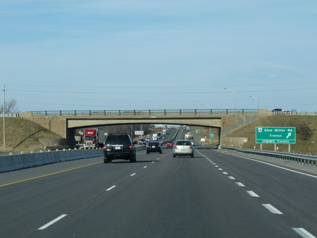
This bridge is an example of the less common rigid-frame overpass design. Although the design has a more consistent, smoothly curved arch, the arch does not visually blend into the abutment in the manner that the other more common rigid-frame design does.
About Ontario Freeways With Heritage Bridges
King's Highway 401 is the very busy backbone of Ontario's surface transportation system, running from the province of Quebec to the city of Windsor, and running through Toronto in between. King's Highway 400 is another highway running from Toronto northward to Barrie and beyond. These two freeways are noted for being two of the older freeways in Ontario, although not as old as the Queen Elizabeth Way (QEW). Both KH-401 and KH-400 limited access highways are also noted for a rich and varied collection of bridges dating to the 1950s and 1960s. Many of these bridges are noted for their aesthetically pleasing design. The rigid frame which was so popular in Ontario was adapted for many of the overpasses. Another popular design for bridges of this period appears to have been the reinforced concrete slab, which in some cases was arched, providing an otherwise bland design type with an aesthetically pleasing appearance. Both the concrete slab and rigid-frame bridges were finished in the popular ornamental railing that was popular during the period.
HistoricBridges.org considers those bridges which retain original railings and are either rigid-frames or reinforced concrete slabs with aesthetic design to have at least some level of heritage significance, as long as they date to before 1970. Because many of these bridges have been replaced or irreversibly altered, with more alterations and replacements undoubtedly planned for the future, it is important to identify those bridges which meet this criteria. It is those bridges which should be prioritized for preservation. Even though these bridges may not be the most historically significant of Ontario bridges, it is important to consider the positive effect these visually pleasing overpasses have on a freeway which in many cases would be otherwise boring and ugly in many places if it were not for these bridges.
![]()
Photo Galleries and Videos: Glen Miller Road Bridge
Bridge Photo-Documentation
Original / Full Size PhotosA collection of overview and detail photos. This gallery offers photos in the highest available resolution and file size in a touch-friendly popup viewer.
Alternatively, Browse Without Using Viewer
![]()
Bridge Photo-Documentation
Mobile Optimized PhotosA collection of overview and detail photos. This gallery features data-friendly, fast-loading photos in a touch-friendly popup viewer.
Alternatively, Browse Without Using Viewer
![]()
Maps and Links: Glen Miller Road Bridge
Coordinates (Latitude, Longitude):
Search For Additional Bridge Listings:
Additional Maps:
Google Streetview (If Available)
GeoHack (Additional Links and Coordinates)
Apple Maps (Via DuckDuckGo Search)
Apple Maps (Apple devices only)
Android: Open Location In Your Map or GPS App
Flickr Gallery (Find Nearby Photos)
Wikimedia Commons (Find Nearby Photos)
Directions Via Sygic For Android
Directions Via Sygic For iOS and Android Dolphin Browser

