

View Information About HSR Ratings
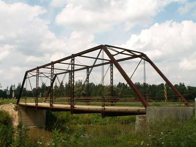
This bridge is a beautiful six panel pin connected Pratt through truss bridge. It features a wooden deck and pole railings. The bridge is seated on concrete abutments.
Pin connected metal truss bridges are not very common in Ontario, and so this is a very significant structure. The Waterloo Region appears to have an unusually large number of pin connected structures, and is unlike other Ontario counties. The preservation of all pin connected metal truss bridges in Ontario should be considered essential, but sadly is not. For each bridge, a number of options are available. A particular bridge could be restored to continue to carry light vehicular traffic. Another option is to bypass the bridge with a modern bridge and preserve the historic structure in its original location for pedestrian use. The third option is to relocate the bridge to a park setting for pedestrian use. While retaining the bridge's original location and function is most desirable, any of these options produce a happy outcome for a historic truss bridge.
At the time this bridge was visited, the north abutment was sinking on the west wingwall side. The result of this was that the truss bridge is slowly sinking at the northern end. This obviously is not a good thing! The deck and deck stringers of the bridge must have extended beyond the bridge itself, because while the truss bridge was sinking, the deck remained, and was now hovering above the bridge's floor beams at the north end. Standing at the north end of the bridge, and the deck would bounce up and down. When a car crossed, the deck would sink back onto the floorbeam, and so the bridge would still "work" when a vehicle crossed. Reportedly, there were plans to repair this problem, but a follow-up visit has not been made to confirm this.
Information and Findings From Waterloo Region Heritage Bridge InventoryWaterloo Region Assigned Heritage Ratings: Overall Score: 60. (Heritage Bridge scores range from 50 up to generally 78) View Heritage Bridge Inventory Data Sheets |
![]()
![]()
![]()
This historic bridge has been demolished. This map is shown for reference purposes only.
Coordinates (Latitude, Longitude):
Search For Additional Bridge Listings:
Additional Maps:
Google Streetview (If Available)
GeoHack (Additional Links and Coordinates)
Apple Maps (Via DuckDuckGo Search)
Apple Maps (Apple devices only)
Android: Open Location In Your Map or GPS App
Flickr Gallery (Find Nearby Photos)
Wikimedia Commons (Find Nearby Photos)
Directions Via Sygic For Android
Directions Via Sygic For iOS and Android Dolphin Browser

© Copyright 2003-2024, HistoricBridges.org. All Rights Reserved. Disclaimer: HistoricBridges.org is a volunteer group of private citizens. HistoricBridges.org is NOT a government agency, does not represent or work with any governmental agencies, nor is it in any way associated with any government agency or any non-profit organization. While we strive for accuracy in our factual content, HistoricBridges.org offers no guarantee of accuracy. Information is provided "as is" without warranty of any kind, either expressed or implied. Information could include technical inaccuracies or errors of omission. Opinions and commentary are the opinions of the respective HistoricBridges.org member who made them and do not necessarily represent the views of anyone else, including any outside photographers whose images may appear on the page in which the commentary appears. HistoricBridges.org does not bear any responsibility for any consequences resulting from the use of this or any other HistoricBridges.org information. Owners and users of bridges have the responsibility of correctly following all applicable laws, rules, and regulations, regardless of any HistoricBridges.org information.
![]()