

View Information About HSR Ratings
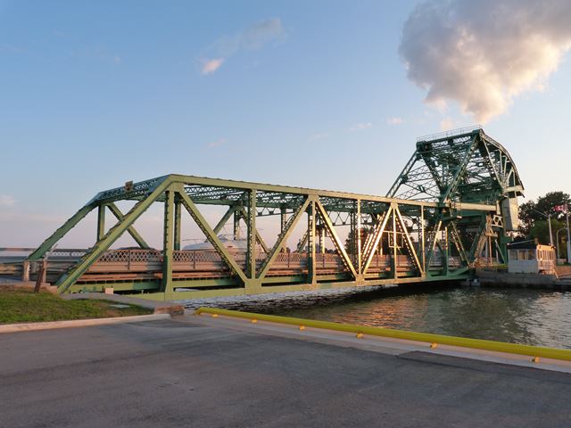
This bridge is a large and exceedingly rare example of a Strauss heel-trunnion bascule bridge in Canada. Famous engineer Joseph Strauss's single leaf heel-trunnion bridge were more common on railways, but are today rare anywhere in Canada, partially due to demolition. Compared to other Strauss heel-trunnion bascule bridges, this one has a very unique appearance that makes the bridge unique. This is due to two factors. First, the rocking truss that holds the counterweight and rotates around the counterweight trunnion has more angles to it, and more diagonals extending from the counterweight trunnion that with most heel trunnion bascule bridges. This gives this portion of the bridge a more curved-like appearance. Secondly, the top chord of the bascule leaf is not parallel to the bottom chord, and instead the truss depth decreases as it extends away from the counterweight link.
This bridge remains in outstanding condition today. The bridge was rehabilitated with MMM Group Limited as lead consultant. Sitting in the middle of a causeway, the bridge is hard to ignore and is a recognizable landmark. Some alterations have been made to the bridge over the years. Some of the vertical members have what was likely originally v-lacing or lattice replaced with plate with circular holes in it. A historical photo of the bridge shows a highly ornamental bridge tender house next to the bridge at the level of the top chord. Today, this no longer remains. The current bridge tender house is located at ground level at the northwest quadrant around the bridge. Inside, it contains modernized operating control panels for the bridge. The concrete counterweight has had steel paneling added around it.
As of 2013, there has been talk of building a second bridge to cross the river and bay in this area, but currently it does not appear that this highly significant heritage bridge is at risk for demolition.

![]()

© Copyright 2003-2024, HistoricBridges.org. All Rights Reserved. Disclaimer: HistoricBridges.org is a volunteer group of private citizens. HistoricBridges.org is NOT a government agency, does not represent or work with any governmental agencies, nor is it in any way associated with any government agency or any non-profit organization. While we strive for accuracy in our factual content, HistoricBridges.org offers no guarantee of accuracy. Information is provided "as is" without warranty of any kind, either expressed or implied. Information could include technical inaccuracies or errors of omission. Opinions and commentary are the opinions of the respective HistoricBridges.org member who made them and do not necessarily represent the views of anyone else, including any outside photographers whose images may appear on the page in which the commentary appears. HistoricBridges.org does not bear any responsibility for any consequences resulting from the use of this or any other HistoricBridges.org information. Owners and users of bridges have the responsibility of correctly following all applicable laws, rules, and regulations, regardless of any HistoricBridges.org information.
![]()
