

View Information About HSR Ratings
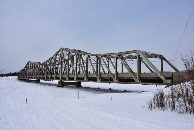
This is an extremely rare surviving example of a continuous through truss bridge in Ontario, and especially stands out as noteworthy in northern Ontario. The bridge features a 91.4 meter (300 foot) central span, with 64 meter (210) side spans. The use of a Pratt-style truss configuration is also exceedingly unusual for this type of bridge, Warren truss configurations are almost exclusively used for continuous through truss bridges.
The official opening for the bridge was in September 1958, costing $1,000,000 to complete. The piers of the bridge are reinforced with steel because the river was used for logging (loggers would float logs down the river toward their destination in large quantities). The portal bracing has been altered to increase vertical clearance. From the 1920s to 1956, the dam was used to cross across the Mattagami on Highway 11. When the dam started to show its age, they built a bailey bridge next to it, which was the longest in Ontario at the time, as a temporary bridge while the existing truss bridge was under construction.

Photo Credit: Mathieu Martel
![]()
![]()
![]()
Coordinates (Latitude, Longitude):
Search For Additional Bridge Listings:
Additional Maps:
Google Streetview (If Available)
GeoHack (Additional Links and Coordinates)
Apple Maps (Via DuckDuckGo Search)
Apple Maps (Apple devices only)
Android: Open Location In Your Map or GPS App
Flickr Gallery (Find Nearby Photos)
Wikimedia Commons (Find Nearby Photos)
Directions Via Sygic For Android
Directions Via Sygic For iOS and Android Dolphin Browser

© Copyright 2003-2024, HistoricBridges.org. All Rights Reserved. Disclaimer: HistoricBridges.org is a volunteer group of private citizens. HistoricBridges.org is NOT a government agency, does not represent or work with any governmental agencies, nor is it in any way associated with any government agency or any non-profit organization. While we strive for accuracy in our factual content, HistoricBridges.org offers no guarantee of accuracy. Information is provided "as is" without warranty of any kind, either expressed or implied. Information could include technical inaccuracies or errors of omission. Opinions and commentary are the opinions of the respective HistoricBridges.org member who made them and do not necessarily represent the views of anyone else, including any outside photographers whose images may appear on the page in which the commentary appears. HistoricBridges.org does not bear any responsibility for any consequences resulting from the use of this or any other HistoricBridges.org information. Owners and users of bridges have the responsibility of correctly following all applicable laws, rules, and regulations, regardless of any HistoricBridges.org information.
![]()