

View Information About HSR Ratings
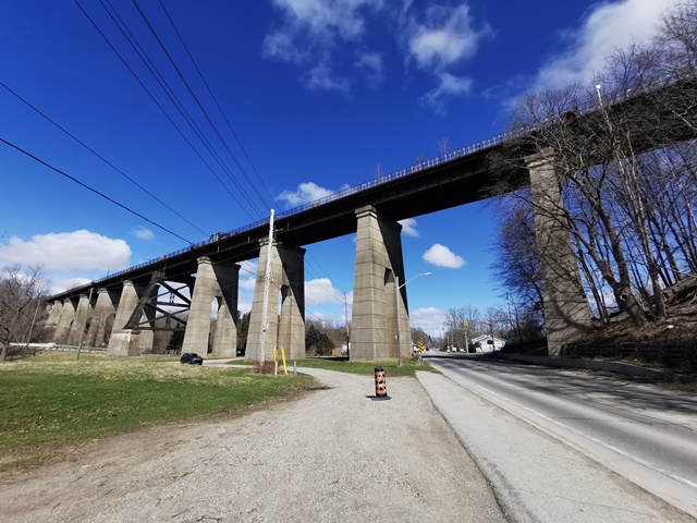
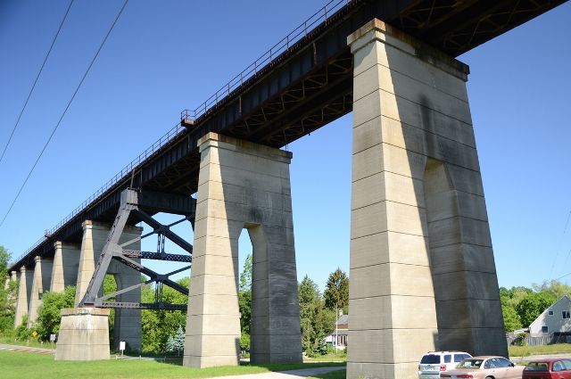
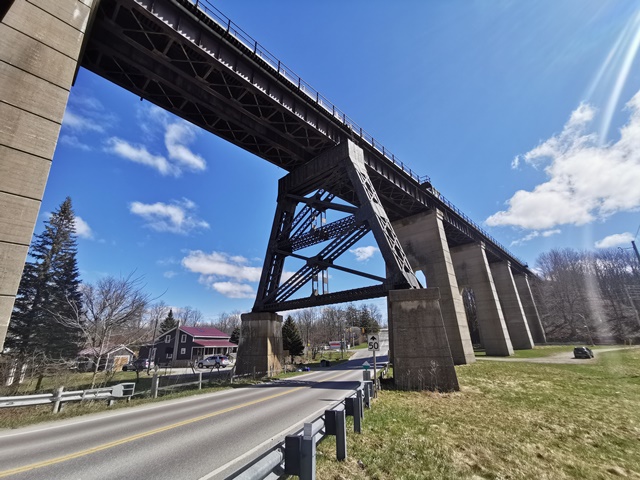
This bridge sits on a historic railway crossing that dates back to 1871. The current structure seen today dates to 1929. While its superstructure of two parallel deck plate girder structures which provided a double-track deck are traditional in composition and do not offer anything unique or unusual, the substructure upon which these spans rest is quite interesting indeed. Rather than using steel bents as was common for high level railroad bridges of this type, the bridge sits on massive concrete piers that give the bridge a striking, imposing appearance. There is one exception. The bridge crosses over a road that crosses under the bridge at a skew right where a pier for the railroad bridge would need to be. To deal with this problem, a special steel bent is employed that allows the beams that support the bridge to be located on either side of the road. This single pier only adds to the landmark identity of the bridge, giving it an appearance shared by no other bridge.
Read the Heritage Impact Report linked below for a detailed history of the bridge and previous bridges at this location.
This bridge has been, with substantial community support, been converted into a linear park and trail called the St. Thomas Elevated Park.
The historic and technological significance of the bridge is recognized by the Canadian Society for Civil Engineer as a National Historic Civil Engineering Site as indicated by a plaque on the bridge.
View the official website for this bridge.
This bridge is tagged with the following special condition(s): Unorganized Photos
![]()
![]()
![]()
![]()
![]()
Coordinates (Latitude, Longitude):
Search For Additional Bridge Listings:
Additional Maps:
Google Streetview (If Available)
GeoHack (Additional Links and Coordinates)
Apple Maps (Via DuckDuckGo Search)
Apple Maps (Apple devices only)
Android: Open Location In Your Map or GPS App
Flickr Gallery (Find Nearby Photos)
Wikimedia Commons (Find Nearby Photos)
Directions Via Sygic For Android
Directions Via Sygic For iOS and Android Dolphin Browser

© Copyright 2003-2024, HistoricBridges.org. All Rights Reserved. Disclaimer: HistoricBridges.org is a volunteer group of private citizens. HistoricBridges.org is NOT a government agency, does not represent or work with any governmental agencies, nor is it in any way associated with any government agency or any non-profit organization. While we strive for accuracy in our factual content, HistoricBridges.org offers no guarantee of accuracy. Information is provided "as is" without warranty of any kind, either expressed or implied. Information could include technical inaccuracies or errors of omission. Opinions and commentary are the opinions of the respective HistoricBridges.org member who made them and do not necessarily represent the views of anyone else, including any outside photographers whose images may appear on the page in which the commentary appears. HistoricBridges.org does not bear any responsibility for any consequences resulting from the use of this or any other HistoricBridges.org information. Owners and users of bridges have the responsibility of correctly following all applicable laws, rules, and regulations, regardless of any HistoricBridges.org information.
![]()