

View Information About HSR Ratings
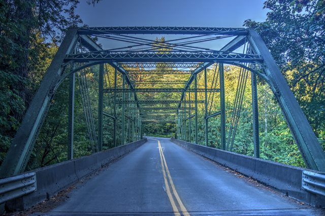
This bridge is one of two spans in Clackamas County which both came from the former Burnside Bridge in Portland, which dated to 1894 and was replaced in 1926, at which time these spans were moved here. This fact gives the two bridges in Clackamas County high significance in several categories. 19th Century pin-connected truss bridges in large urban cities were mostly replaced in the first half of the 20th century. Thus, very little examples of urban 19th century pin-connected truss bridges survive today. Because these spans were moved to rural areas, they managed to survive to the present day, making them very rare. These bridges are also noteworthy as some of the oldest metal truss bridges in Oregon, and their pin-connected truss design is particularly rare in the context of Oregon's primarily 20th century collection of historic bridges. Lastly, these truss spans, which were designed with wide decks and heavy truss members (for the period) show a complex and unusual design not normally found in pin-connected highway truss bridges. Parts of the bridge which would normally be expected to be simple components, such as the portal bracing and sway bracing, are very complex structures with their own members and pin connections on this bridge.
This bridge is the smaller of the two spans.

Above: Historical photo showing the old Burnside Bridge in Portland, a swing bridge, from whose fixed approach truss spans were salvaged and relocated to Clackamas County.
![]()
![]()
![]()
Coordinates (Latitude, Longitude):
Search For Additional Bridge Listings:
Bridgehunter.com: View listed bridges within 0.5 miles (0.8 kilometers) of this bridge.
Bridgehunter.com: View listed bridges within 10 miles (16 kilometers) of this bridge.
Additional Maps:
Google Streetview (If Available)
GeoHack (Additional Links and Coordinates)
Apple Maps (Via DuckDuckGo Search)
Apple Maps (Apple devices only)
Android: Open Location In Your Map or GPS App
Flickr Gallery (Find Nearby Photos)
Wikimedia Commons (Find Nearby Photos)
Directions Via Sygic For Android
Directions Via Sygic For iOS and Android Dolphin Browser
USGS National Map (United States Only)
Historical USGS Topo Maps (United States Only)
Historic Aerials (United States Only)
CalTopo Maps (United States Only)

© Copyright 2003-2026, HistoricBridges.org. All Rights Reserved. Disclaimer: HistoricBridges.org is a volunteer group of private citizens. HistoricBridges.org is NOT a government agency, does not represent or work with any governmental agencies, nor is it in any way associated with any government agency or any non-profit organization. While we strive for accuracy in our factual content, HistoricBridges.org offers no guarantee of accuracy. Information is provided "as is" without warranty of any kind, either expressed or implied. Information could include technical inaccuracies or errors of omission. Opinions and commentary are the opinions of the respective HistoricBridges.org member who made them and do not necessarily represent the views of anyone else, including any outside photographers whose images may appear on the page in which the commentary appears. HistoricBridges.org does not bear any responsibility for any consequences resulting from the use of this or any other HistoricBridges.org information. Owners and users of bridges have the responsibility of correctly following all applicable laws, rules, and regulations, regardless of any HistoricBridges.org information.
![]()