

View Information About HSR Ratings
The bridge has a colorful history. Although this bridge, with its historic significance and stunning beauty, is worthy of its name, its name is actually inherited from the natural land bridge which formed and existed for a period of time long ago in this area.
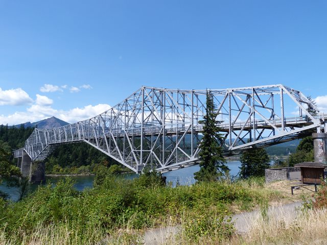
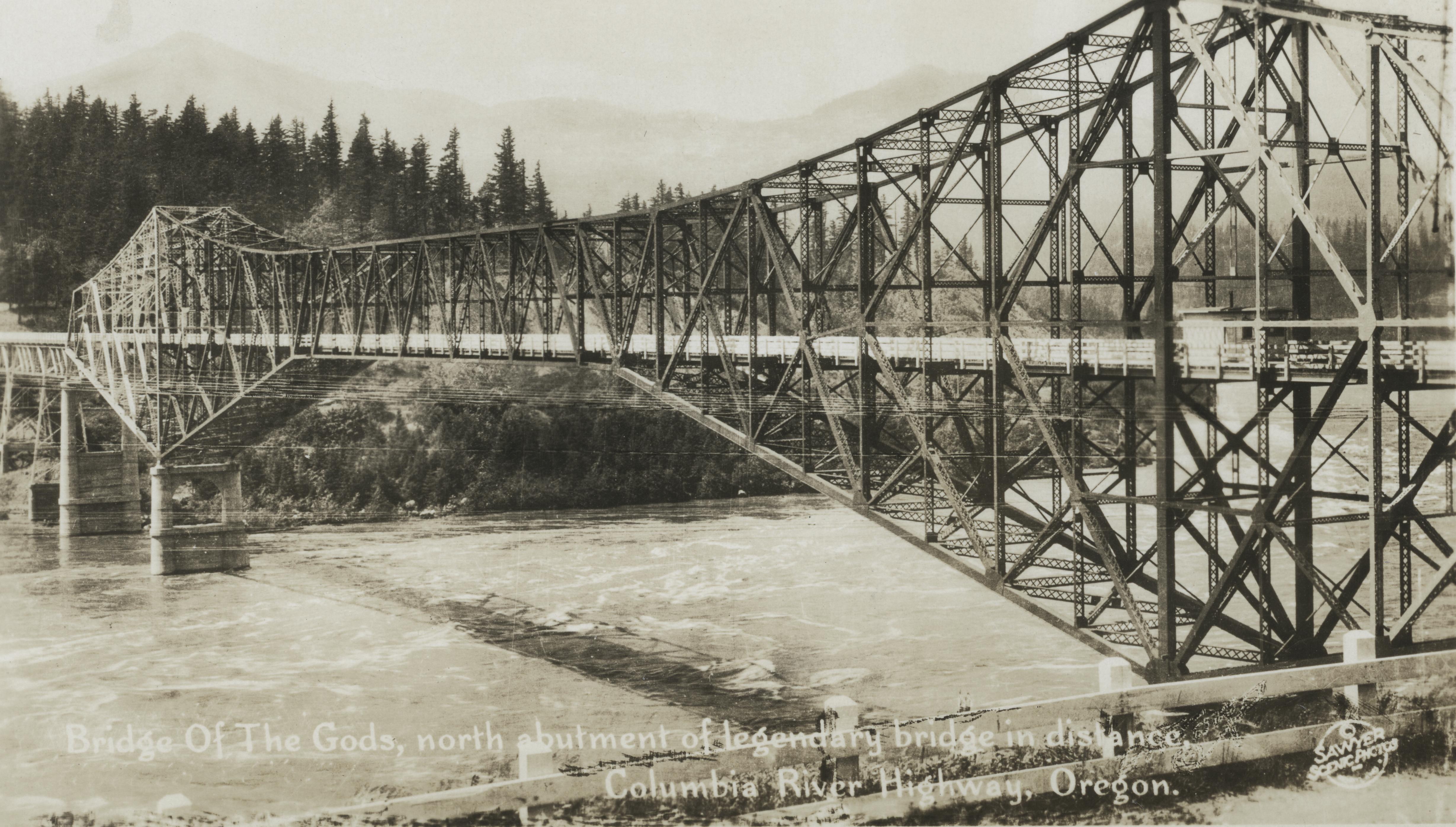
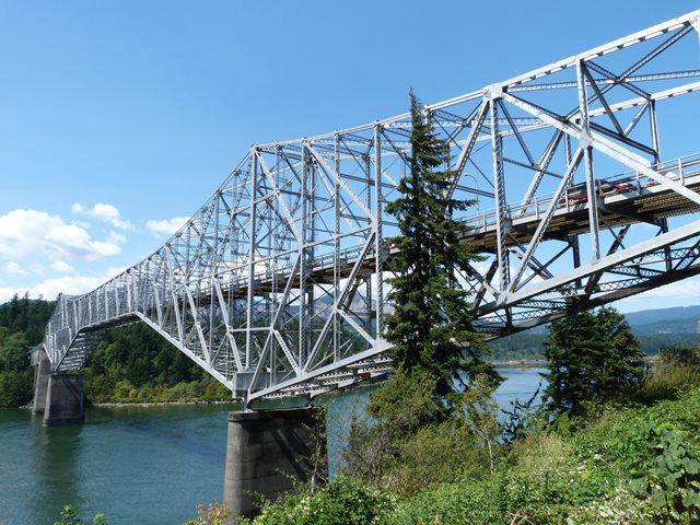
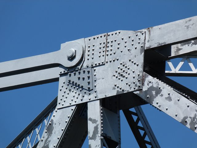
The bridge has always been a toll bridge. A toll bridge company called Interstate Construction Corporation originally formed to build the bridge with an apparently slightly different design of bridge than the one seen today. This first bridge was begun in 1921 but apparently not well-managed, with only one pier being built by 1925. This pier was called Pier 2 or the Oregon Pier. The Wauna Toll Bridge Company of Walla Walla, Washington purchased the bridge from Interstate Construction in October 1926 and had the bridge seen today built, while incorporating the Oregon Pier into the final bridge design. The bridge was 91 feet above the river and had a wooden deck. The original length of the bridge was 1,127 feet. In 1939, the Bonneville Dam was built which caused water levels to rise. To compensate, the bridge was raised 40 feet in an impressive project. The project included constructing enormous riveted lifting girders on the piers, at the base of the bridge's main posts. These lifting girders were not removed after the bridge was raised and can still be seen today. Originally the cantilever truss was the end of the bridge on the Oregon side, but after being raised, additional approach spans were needed. These spans were constructed as arched deck plate girder spans, and they include a cantilever design that has a suspended span. The girder spans, although newer than the truss bridge, appear to have been built with a slightly narrower roadway, which is unusual and it is not known why this was done. In 1953, a new company bought the bridge, the Columbia River Bridge Company. Its ownership did not last long and in 1961 the Port of Cascade Locks Commission purchased the bridge. Port of Cascade Locks continues to own the bridge today. As mentioned the bridge has always been a toll bridge. The toll booth seen today is not the original building. The building was built in 1966, and the covering that is over the booth and roadways is not original, but it is not known when it was constructed... although it dates to before 1966. In 1966, the bridge deck was replaced with the current metal grate deck. The roadway was narrowed at this time to match that of the girder spans. Evidence of this can be seen by the width of the trusses and missing deck stringers at the ends of the floor beams.
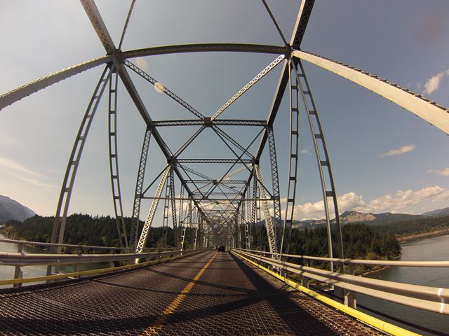
The bridge is described as the third oldest bridge on the Columbia River, making its age significant from a geographic standpoint. More importantly, the bridge has high levels of historic and technological significance. With a construction date of 1926, the bridge is among the oldest highway cantilever bridges in Washington State and nationwide, thanks to widespread demolition in alarming quantities, the bridge is among the oldest surviving highway cantilever truss bridges in the United States. Cantilever truss bridges can take many different design forms. This bridge stands out for having an uncommon design. While the top chord is angled to form pointed towers of trusses that surround the main posts of the truss (a common feature of cantilever trusses), the bottom chord also runs at an angle to come to a point at the main posts far below the deck, which is a much less common design feature nationwide, although Washington State has a number of highway-department designed cantilever truss bridges with this bottom chord arrangement. Unlike the Washington State examples however, the Bridge of the Gods is not a bridge designed by the state highway department.
The trusses of the cantilever structure for the most part take on the form of Warren trusses and subdivided Warren trusses. Around the main posts however, the trusses appear to follow a K-truss configuration.
Aside from being raised 40 feet and the adjustments to the deck configuration, the truss spans retain excellent historic integrity and no major alterations to the original design or materials were noted. The most visually notable alteration on the truss spans is the presence of the lifting girder that was left in place after the bridge was raised. However the girder is useful from a historical standpoint since it helps tell the bridge's unique story.


![]()
![]()
![]()
![]()
![]()
![]()
![]()

![]()
Coordinates (Latitude, Longitude):
Search For Additional Bridge Listings:
Bridgehunter.com: View listed bridges within 0.5 miles (0.8 kilometers) of this bridge.
Bridgehunter.com: View listed bridges within 10 miles (16 kilometers) of this bridge.
Additional Maps:
Google Streetview (If Available)
GeoHack (Additional Links and Coordinates)
Apple Maps (Via DuckDuckGo Search)
Apple Maps (Apple devices only)
Android: Open Location In Your Map or GPS App
Flickr Gallery (Find Nearby Photos)
Wikimedia Commons (Find Nearby Photos)
Directions Via Sygic For Android
Directions Via Sygic For iOS and Android Dolphin Browser
USGS National Map (United States Only)
Historical USGS Topo Maps (United States Only)
Historic Aerials (United States Only)
CalTopo Maps (United States Only)

© Copyright 2003-2024, HistoricBridges.org. All Rights Reserved. Disclaimer: HistoricBridges.org is a volunteer group of private citizens. HistoricBridges.org is NOT a government agency, does not represent or work with any governmental agencies, nor is it in any way associated with any government agency or any non-profit organization. While we strive for accuracy in our factual content, HistoricBridges.org offers no guarantee of accuracy. Information is provided "as is" without warranty of any kind, either expressed or implied. Information could include technical inaccuracies or errors of omission. Opinions and commentary are the opinions of the respective HistoricBridges.org member who made them and do not necessarily represent the views of anyone else, including any outside photographers whose images may appear on the page in which the commentary appears. HistoricBridges.org does not bear any responsibility for any consequences resulting from the use of this or any other HistoricBridges.org information. Owners and users of bridges have the responsibility of correctly following all applicable laws, rules, and regulations, regardless of any HistoricBridges.org information.
![]()