

View Information About HSR Ratings
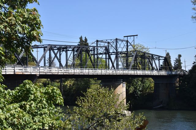
This bridge is the oldest highway swing bridge in Oregon and the only pin-connected movable highway bridge in Oregon. The swing span is in fact composed of a combination of riveted and pinned connections. West of the swing span is an all-pinned Parker truss span. East of the swing span is an all-riveted polygonal Warren pony truss span (an early example of polygonal Warren design) that is unusual for its short length and only a total of four different slopes on the endpost/top chord system (less than even the five slopes of a Camelback truss). There once was a similar pony truss span at the western end of this bridge, but that has been mostly replaced with a stringer beam system, although some of the floorbeams and connections of the pony truss were left behind, resulting in a rather unusual appearance in the westernmost spans of this bridge, which are visible in detail from the walkway that passes under these approach spans.
Note that the sway bracing on the through truss spans was altered at some point to increase vertical clearance. Although this bridge does not operate for boats anymore, the swing span retains the integrity of its design to allow it to retain high significance, especially considering the rarity of this type of bridge in Oregon.
This bridge only carries eastbound traffic today, with a nearby newer bridge carrying westbound traffic.
![]()
![]()
![]()
This historic bridge has been demolished. This map is shown for reference purposes only.
Coordinates (Latitude, Longitude):
Search For Additional Bridge Listings:
Bridgehunter.com: View listed bridges within 0.5 miles (0.8 kilometers) of this bridge.
Bridgehunter.com: View listed bridges within 10 miles (16 kilometers) of this bridge.
Additional Maps:
Google Streetview (If Available)
GeoHack (Additional Links and Coordinates)
Apple Maps (Via DuckDuckGo Search)
Apple Maps (Apple devices only)
Android: Open Location In Your Map or GPS App
Flickr Gallery (Find Nearby Photos)
Wikimedia Commons (Find Nearby Photos)
Directions Via Sygic For Android
Directions Via Sygic For iOS and Android Dolphin Browser
USGS National Map (United States Only)
Historical USGS Topo Maps (United States Only)
Historic Aerials (United States Only)
CalTopo Maps (United States Only)

© Copyright 2003-2024, HistoricBridges.org. All Rights Reserved. Disclaimer: HistoricBridges.org is a volunteer group of private citizens. HistoricBridges.org is NOT a government agency, does not represent or work with any governmental agencies, nor is it in any way associated with any government agency or any non-profit organization. While we strive for accuracy in our factual content, HistoricBridges.org offers no guarantee of accuracy. Information is provided "as is" without warranty of any kind, either expressed or implied. Information could include technical inaccuracies or errors of omission. Opinions and commentary are the opinions of the respective HistoricBridges.org member who made them and do not necessarily represent the views of anyone else, including any outside photographers whose images may appear on the page in which the commentary appears. HistoricBridges.org does not bear any responsibility for any consequences resulting from the use of this or any other HistoricBridges.org information. Owners and users of bridges have the responsibility of correctly following all applicable laws, rules, and regulations, regardless of any HistoricBridges.org information.
![]()