

View Information About HSR Ratings

This bridge was originally built at Corrine, Utah over the Bear River on the Central Pacific Railroad in 1882. The bridge was replaced and relocated starting in 1896 and completing with the erection of the truss in its current location here over the McKenzie River in Oregon.
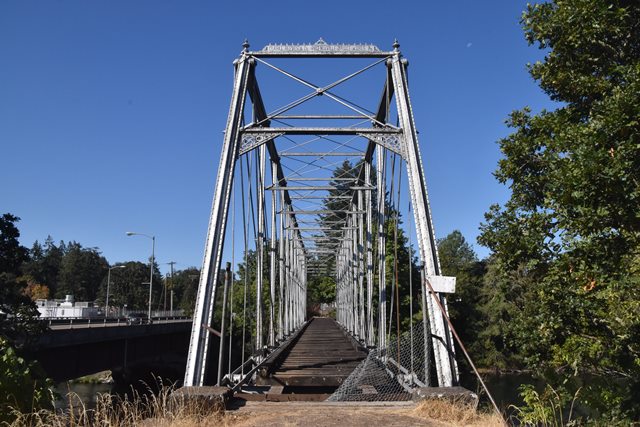
This bridge is one of the most significant bridges in the country that uses Phoenix columns. Any bridge with Phoenix columns is extremely rare and significant, but this one stands out for many more reasons. The longer 224 foot span length and rare Whipple truss configuration is noteworthy. The lack of alteration including intact portal plaques and ornamentation makes this bridge stand out from many other bridges with Phoenix columns. There is very little deterioration on the bridge as well. The bridge has some unique design details including unusual longitudinal rods that are below and parallel to the bottom chord, forming an "X" between floorbeams. Perhaps the most significant aspect is the fact that this is one of the earliest surviving bridges with Phoenix columns. The bridge is so old, that the plaque does not list the name as the Phoenix Bridge Company, instead using the earlier company name Clarke, Reeves and Company. As such, this nationally significant bridge is one of Oregon's most important historic bridges.
This former railroad bridge is now abandoned. Ownership has been assumed by the nonprofit organization Workin' Bridges who is working to preserve the bridge and plans to redeck the bridge for pedestrian traffic and create a small bridge-focused park next to the bridge.

Above: This historical photo provided by Chris Bell at ODOT is reportedly a photo of the bridge in Utah being disassembled.
This bridge is tagged with the following special condition(s): Phoenix Columns
![]()
![]()
![]()
Coordinates (Latitude, Longitude):
Search For Additional Bridge Listings:
Bridgehunter.com: View listed bridges within 0.5 miles (0.8 kilometers) of this bridge.
Bridgehunter.com: View listed bridges within 10 miles (16 kilometers) of this bridge.
Additional Maps:
Google Streetview (If Available)
GeoHack (Additional Links and Coordinates)
Apple Maps (Via DuckDuckGo Search)
Apple Maps (Apple devices only)
Android: Open Location In Your Map or GPS App
Flickr Gallery (Find Nearby Photos)
Wikimedia Commons (Find Nearby Photos)
Directions Via Sygic For Android
Directions Via Sygic For iOS and Android Dolphin Browser
USGS National Map (United States Only)
Historical USGS Topo Maps (United States Only)
Historic Aerials (United States Only)
CalTopo Maps (United States Only)

© Copyright 2003-2025, HistoricBridges.org. All Rights Reserved. Disclaimer: HistoricBridges.org is a volunteer group of private citizens. HistoricBridges.org is NOT a government agency, does not represent or work with any governmental agencies, nor is it in any way associated with any government agency or any non-profit organization. While we strive for accuracy in our factual content, HistoricBridges.org offers no guarantee of accuracy. Information is provided "as is" without warranty of any kind, either expressed or implied. Information could include technical inaccuracies or errors of omission. Opinions and commentary are the opinions of the respective HistoricBridges.org member who made them and do not necessarily represent the views of anyone else, including any outside photographers whose images may appear on the page in which the commentary appears. HistoricBridges.org does not bear any responsibility for any consequences resulting from the use of this or any other HistoricBridges.org information. Owners and users of bridges have the responsibility of correctly following all applicable laws, rules, and regulations, regardless of any HistoricBridges.org information.
![]()