

View Information About HSR Ratings
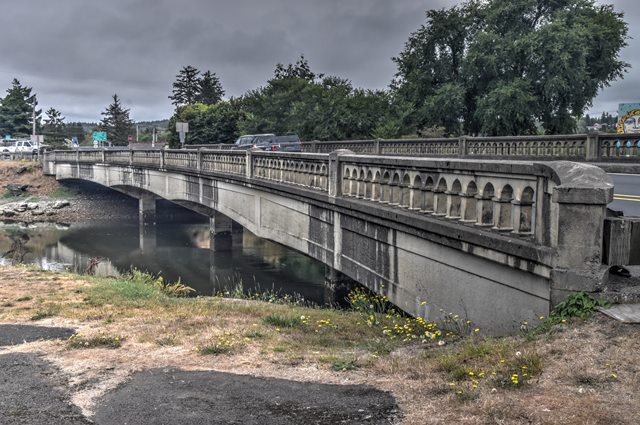
This concrete t-beam bridge is noted for its use of a then-new engineering theory in its design. It also has an attractive visual design, something that its designer, the noted Conde McCullough was famous for.
The bridge was documented by the Historic American Engineering Record who provided the following information:
Significance: The Neawanna Creek Bridge #1305 is significant as an intact example of a 1930s continuous concrete, multi-span highway bridge, utilizing Hardy Cross's moment distribution theory, and for its association with C.B. McCullough, Oregon's premier bridge engineer. The configuration of continuous concrete T-Beam construction utilized in the design of the 1930 Neawanna Creek Bridge represents a significant change in structural engineering theory and reinforced concrete technology by applying the moment distribution technique of distributing loads on girder structures. The moment distribution theory for continuous concrete frames was developed in the late 1920s by Hardy Cross, a civil engineer and professor of structural engineering at the University of Illinois. Hardy Cross was regarded by his contemporaries as a leader in a new school of thought in the field of structural analysis, and his theory is regarded by many architects and engineers to be one of the more significant structural theories developed during the 20th century. C.B. McCullough served as State Bridge Engineer, and later as the Assistant State Highway Engineer, of Oregon from 1919 until his death in 1946. He authored a number of books and technical articles on bridge design and construction. McCullough is significant for his use of innovative bridge technology, and for his visually appealing designs. He had attained international recognition for the large-scale structures designed to span the major rivers and estuaries along the Oregon coast for the completion of the Orange Coast Highway in the 1930s.
![]()
![]()
![]()
Coordinates (Latitude, Longitude):
Search For Additional Bridge Listings:
Bridgehunter.com: View listed bridges within 0.5 miles (0.8 kilometers) of this bridge.
Bridgehunter.com: View listed bridges within 10 miles (16 kilometers) of this bridge.
Additional Maps:
Google Streetview (If Available)
GeoHack (Additional Links and Coordinates)
Apple Maps (Via DuckDuckGo Search)
Apple Maps (Apple devices only)
Android: Open Location In Your Map or GPS App
Flickr Gallery (Find Nearby Photos)
Wikimedia Commons (Find Nearby Photos)
Directions Via Sygic For Android
Directions Via Sygic For iOS and Android Dolphin Browser
USGS National Map (United States Only)
Historical USGS Topo Maps (United States Only)
Historic Aerials (United States Only)
CalTopo Maps (United States Only)

© Copyright 2003-2024, HistoricBridges.org. All Rights Reserved. Disclaimer: HistoricBridges.org is a volunteer group of private citizens. HistoricBridges.org is NOT a government agency, does not represent or work with any governmental agencies, nor is it in any way associated with any government agency or any non-profit organization. While we strive for accuracy in our factual content, HistoricBridges.org offers no guarantee of accuracy. Information is provided "as is" without warranty of any kind, either expressed or implied. Information could include technical inaccuracies or errors of omission. Opinions and commentary are the opinions of the respective HistoricBridges.org member who made them and do not necessarily represent the views of anyone else, including any outside photographers whose images may appear on the page in which the commentary appears. HistoricBridges.org does not bear any responsibility for any consequences resulting from the use of this or any other HistoricBridges.org information. Owners and users of bridges have the responsibility of correctly following all applicable laws, rules, and regulations, regardless of any HistoricBridges.org information.
![]()