


View Information About HSR Ratings
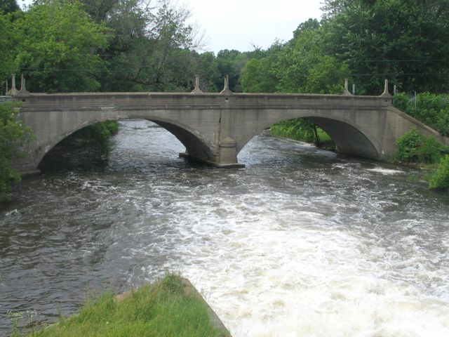
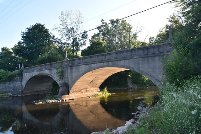
This beautiful bridge complements its setting well. The Michigan State Highway Department designed this structure, and its trademark features can be seen in the inset rectangles on the bridge as well as the bronze plaques on the bridge. Decorative posts are also present on this bridge, which was built in 1920. It is listed as a State Reward Bridge Number 53.
The previous bridge at this location was a through truss as the below postcard shows.
By 2016, the dam located next to this bridge had been removed to return the river to a natural state.

Information and Findings From MDOT
The 12 Mile Road Bridge is eligible for the National Register as a good
example of a filled-spandrel concrete arch bridge with excellent
historical integrity. |
![]()
Information and Findings From Michigan Historic Sites OnlineNarrative Description: The 12 Mile Road Bridge is located in the village of Ceresco. A dam is located to the east of the structure. The bridge displays solid concrete parapet railings with ten recesses each. A tapered projecting stringcourse trims the elliptical barrel vault. Concrete lamp posts, missing their fixtures, stand at the corners and in the middle of the railings. Bridge plates are attached at the northwest and southeast corners. main span number: 2 main span length: 57.5 structure length: 115.0 roadway width: 24.5 structure width: 20.7
Calhoun County presumably built the 12 Mile Road Bridge in 1920 as State Reward Bridge No. 53. According to the bridge plates, contractors for the project were L. Smith, H. A. Nichols, and M. C. Nichols, of Hastings, Michigan. Archival research did not provide any additional information. The 12 Mile Road Bridge is eligible for the National Register under Criterion C as a good example of the filled-spandrel concrete arch bridge type with excellent historical integrity. |
This bridge is tagged with the following special condition(s): Unorganized Photos
![]()

![]()
![]()
![]()
![]()
![]()
Coordinates (Latitude, Longitude):
Search For Additional Bridge Listings:
Bridgehunter.com: View listed bridges within 0.5 miles (0.8 kilometers) of this bridge.
Bridgehunter.com: View listed bridges within 10 miles (16 kilometers) of this bridge.
Additional Maps:
Google Streetview (If Available)
GeoHack (Additional Links and Coordinates)
Apple Maps (Via DuckDuckGo Search)
Apple Maps (Apple devices only)
Android: Open Location In Your Map or GPS App
Flickr Gallery (Find Nearby Photos)
Wikimedia Commons (Find Nearby Photos)
Directions Via Sygic For Android
Directions Via Sygic For iOS and Android Dolphin Browser
USGS National Map (United States Only)
Historical USGS Topo Maps (United States Only)
Historic Aerials (United States Only)
CalTopo Maps (United States Only)

© Copyright 2003-2026, HistoricBridges.org. All Rights Reserved. Disclaimer: HistoricBridges.org is a volunteer group of private citizens. HistoricBridges.org is NOT a government agency, does not represent or work with any governmental agencies, nor is it in any way associated with any government agency or any non-profit organization. While we strive for accuracy in our factual content, HistoricBridges.org offers no guarantee of accuracy. Information is provided "as is" without warranty of any kind, either expressed or implied. Information could include technical inaccuracies or errors of omission. Opinions and commentary are the opinions of the respective HistoricBridges.org member who made them and do not necessarily represent the views of anyone else, including any outside photographers whose images may appear on the page in which the commentary appears. HistoricBridges.org does not bear any responsibility for any consequences resulting from the use of this or any other HistoricBridges.org information. Owners and users of bridges have the responsibility of correctly following all applicable laws, rules, and regulations, regardless of any HistoricBridges.org information.
![]()