We Recommend:
Bach Steel - Experts at historic truss bridge restoration.
BridgeHunter.com Phase 1 is released to the public! - Visit Now
Wadhams Bridge

Primary Photographer(s): Nathan Holth
Bridge Documented: 2005, April 2010, and June 5, 2011
Wadhams: St. Clair County, Michigan: United States
1939 By Builder/Contractor: E. C. Nolan and Son of Detroit, Michigan
1976
68.0 Feet (20.7 Meters)
527.0 Feet (160.6 Meters)
26 Feet (7.92 Meters)
3 Main Span(s) and 9 Approach Span(s)
77200066000B030

View Information About HSR Ratings
Bridge Documentation
This bridge no longer exists!
Bridge Status: This bridge was demolished and replaced in 2010-2011!View Archived National Bridge Inventory Report - Has Additional Details and Evaluation
Design and Significance

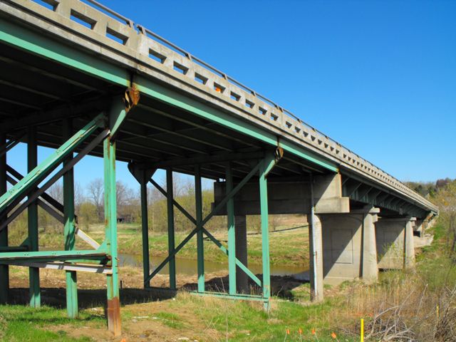
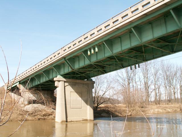
The Wadhams Bridge has the appearance a 1970s bridge on top, but a look from below reveals this to be a much older deck plate girder bridge. Although it was primarily an important rural arterial road, this bridge now carries a lot of suburban and commuter traffic these days.
This bridge has an impressive 6% grade, making it very unusual for Michigan, and even moreso for eastern Michigan and the thumb area which is normally extremely flat. Indeed, the section of Black River beginning a few miles downstream from the Wadhams Bridge and continuing upstream a number of miles until nearly Croswell, has some of the greatest terrain relief in the region.
Built in 1939, the bridge is also an early example of a highway deck plate girder in Michigan. Most of Michigan's limited number of examples of this technology appear to date to between 1945 and 1960.
These initial statements would appear to suggest that this bridge would have a high level of historic significance. Unfortunately, serious alterations to the original bridge design and materials have diminished the historic significance of the bridge, although it does remain a locally noteworthy structure.
One of the concrete piers have been replaced. What originally appears to have been a northern abutment was reconfigured to act as a pier, and an additional stringer approach span was added. Some of the steel approach bents have had additional steel welded on. The deck has been widened and replaced. This was done by adding an extra beam to each side of the steel stringer approaches. The main span was widened by bolting steel cantilevers onto the bridge. As a result, original guardrails do not remain on this bridge. A sidewalk is present on the east side of the deck. A plaque, mounted on the new guardrails, shows the original bridge having a construction date of 1939. A second plaque, much newer, shows a date of 1976, presumably showing when these modifications were completed.
Previous Structures
The Wadhams Road Bridge is a crossing which has existed for a long time, and the 1940 Wadhams Road Bridge is at least the third bridge at the location.
The 1940 bridge took the place of a bridge that consisted of a single pin-connected Pratt through truss main span, with stringer approach spans which stood long after this bridge was built, but is no longer extant. The remains are located a bit west of the current bridge in the form of ruined caissons. The location of this truss bridge was along a straight line between Bartlett road south of the Lapeer road and Wadhams Road north of the end of Vincent. This is the former alignment of the roadway. Back in the time this truss bridge was in use, I-69 did not exist, and Bartlett Road would have passed through the area (it is a dead end at the freeway today) and rejoined the alignment of current Wadhams Road south of where I-69 is today.
The truss bridge was a replacement for the first known bridge at the crossing, which was a massive wooden structure, often referred to as a "trestle" which spanned the entire river valley. It is ironic that the oldest bridge was the largest structure, the most complex structure, and also was the only structure to eliminate the steep grade caused by the river valley. The wooden bridge was located on an alignment between the 1940 bridge and the metal truss bridge. Broken wooden posts still stick out of the river when the water level is low at this location, and these are the only physical remains of this bridge.
Final Years Leading Leading Up To Replacement
The Wadhams Bridge is a structure that in the last 15-20 years of its life observed rapid decreases in its structural condition and well as its functional sufficiency, not so much due to the life expectancy of the bridge, but moreso due to poor planning decisions and deferred maintenance. Simple decisions, like choosing to ignore a faulty and leaky expansion joint, choosing to sign freeway exits to direct onto the bridge as a Port Huron bypass, and even choosing to switch from cinders to salt for deicing purposes all led to the decision to replace and demolish the bridge. The past use of cinders on the bridge is of particular interest. Many years ago, cinders were put down to provide traction in the winter, reducing or eliminating the need for corrosive deicing salts. The idea was to preserve the deck of the bridge. However, the road commission stopped doing that some time ago, and started salting the bridge, which almost immediately started advancing the deterioration on the bridge. Cinders may not be the best method for dealing with winter ice, but the fact that salt is indiscriminately dumped on the bridge today when it was not in years past calls attention to the fact that bridges today are given less respect and care than they once were. The functional sufficiency of the bridge was reduced greatly when actions were taken to dramatically increase traffic on the bridge. Wadhams Bridge was made part of a strange signed Alternate 69/94 to M-25 Route, which was apparently designed to relieve traffic on the expressway and M-25 through Port Huron. Signed "Alternate Routes" are not a normal part of any highway system in Michigan. This alternate route had the effect of routing a large amount of traffic onto once-rural roads as well as this bridge, none of which were designed for heavy traffic.
On June 5, 2006, the Wadhams Road Bridge over the Black River was posted for reduced weight limit as follows: Single Unit 42 Tons, Double Unit 66 Tons, Triple Unit 74 Tons. Soon afterwards, a proposal was made to demolish and replace the bridge with a structure that would offer additional lanes for traffic. There was also an effort to accelerate the project because of even further anticipated increases of traffic due to the replacement of the I-69/I-94 Black River Bridge, which is the next bridge downstream.
The replacement bridge was started in 2010, with the 1940 bridge to remain open to the majority of the project before it will be demolished to allow the replacement bridge to complete. The replacement bridge is a nondescript haunched girder bridge typically used for long spans. It might seem unusual to Michigan residents, but residents of states with more terrain relief and larger rivers like Missouri, Ohio, and Pennsylvania, will immediately recognize it for the bland, ugly, cookie cutter structure it is.
This bridge is tagged with the following special condition(s): Unorganized Photos
![]()
Photo Galleries and Videos: Wadhams Bridge
2010 Bridge Photo-Documentation
Original / Full Size PhotosA collection of overview and detail photos, taken April 2010. Includes photos of the remains of the first high-level wooden bridge. This gallery offers photos in the highest available resolution and file size in a touch-friendly popup viewer.
Alternatively, Browse Without Using Viewer
![]()
2010 Bridge Photo-Documentation
Mobile Optimized PhotosA collection of overview and detail photos, taken April 2010. Includes photos of the remains of the first high-level wooden bridge. This gallery features data-friendly, fast-loading photos in a touch-friendly popup viewer.
Alternatively, Browse Without Using Viewer
![]()
2005 Bridge Photo-Documentation
A collection of overview and detail photos taken in late 2005. Includes newspaper article clippings relating to the previous bridges as well as photos of the remains of the previous truss bridge. This photo gallery contains a combination of Original Size photos and Mobile Optimized photos in a touch-friendly popup viewer.Alternatively, Browse Without Using Viewer
![]()
Additional Unorganized Demolition Photos
Original / Full Size PhotosA supplemental collection of photos that are from additional visit(s) to the bridge and have not been organized or captioned. This gallery offers photos in the highest available resolution and file size in a touch-friendly popup viewer.
Alternatively, Browse Without Using Viewer
![]()
Additional Unorganized Demolition Photos
Mobile Optimized PhotosA supplemental collection of photos that are from additional visit(s) to the bridge and have not been organized or captioned. This gallery features data-friendly, fast-loading photos in a touch-friendly popup viewer.
Alternatively, Browse Without Using Viewer
![]()
Additional Unorganized Photos
Original / Full Size PhotosThis photo gallery features older ca. 2003-2006 photos taken when the website only included a few photos in original size on the website, and a smaller quantity of reduced size photos as well. This unorganized gallery may partially duplicate photos in other galleries on this bridge's page, however all photos here are available in the Original / Full Size. This gallery offers photos in the highest available resolution and file size in a touch-friendly popup viewer.
Alternatively, Browse Without Using Viewer
![]()
Additional Unorganized Photos
Mobile Optimized PhotosThis photo gallery features older ca. 2003-2006 photos taken when the website only included a few photos in original size on the website, and a smaller quantity of reduced size photos as well. This unorganized gallery may partially duplicate photos in other galleries on this bridge's page, however all photos here are available in the Original / Full Size. This gallery features data-friendly, fast-loading photos in a touch-friendly popup viewer.
Alternatively, Browse Without Using Viewer
![]()
Maps and Links: Wadhams Bridge
This historic bridge has been demolished. This map is shown for reference purposes only.
Note the old alignment of Wadhams Road was Bartlett Road. The truss bridge remains are where Bartlett road ends at Black River. The observant traveler will note that the original downtown if it can be called that, is at the intersection of Lapeer and Bartlett and not Wadhams and Lapeer.
Coordinates (Latitude, Longitude):
Search For Additional Bridge Listings:
Bridgehunter.com: View listed bridges within 0.5 miles (0.8 kilometers) of this bridge.
Bridgehunter.com: View listed bridges within 10 miles (16 kilometers) of this bridge.
Additional Maps:
Google Streetview (If Available)
GeoHack (Additional Links and Coordinates)
Apple Maps (Via DuckDuckGo Search)
Apple Maps (Apple devices only)
Android: Open Location In Your Map or GPS App
Flickr Gallery (Find Nearby Photos)
Wikimedia Commons (Find Nearby Photos)
Directions Via Sygic For Android
Directions Via Sygic For iOS and Android Dolphin Browser
USGS National Map (United States Only)
Historical USGS Topo Maps (United States Only)
Historic Aerials (United States Only)
CalTopo Maps (United States Only)


