

View Information About HSR Ratings
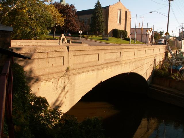
 Perhaps one of the reasons this very old 1916 arch bridge
still carries four lanes of traffic is because it once carried an inter-urban
railway on it as well. This only lasted for three years, and then the rails were
removed. However, the additional width that the bridge was originally designed
with allowed the road to have four lanes of decent size, allowing it to carry the traffic it
does today.
Perhaps one of the reasons this very old 1916 arch bridge
still carries four lanes of traffic is because it once carried an inter-urban
railway on it as well. This only lasted for three years, and then the rails were
removed. However, the additional width that the bridge was originally designed
with allowed the road to have four lanes of decent size, allowing it to carry the traffic it
does today.
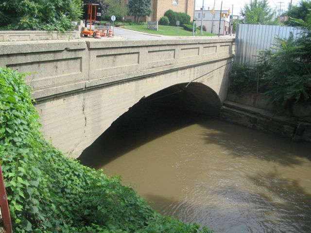
This bridge is in good condition, no weight limit is posted, and the 2006 National Bridge Inventory provides a sufficiency rating of 72%, which is very high for a historic bridge, especially one on a fairly well-traveled road.
The bridge is somewhat hard to get photos of, due to fences, trees, buildings, and other such obstacles.
An interesting note is that the trunk line bridge that was built just before this one, Watervliet Road Bridge Trunk Line Bridge #57 (the Chicago Avenue Bridge is #58) was documented by HistoricBridges.org. Although demolished now, it was an unusual occurrence to find both bridges that were built one right after the other still standing. . I thought it was interesting that two consecutive trunk line bridges were still standing for me to photograph.
This bridge is listed in the National Register of Historic Places.
Information and Findings From Michigan Historic Bridge InventoryNarrative Description
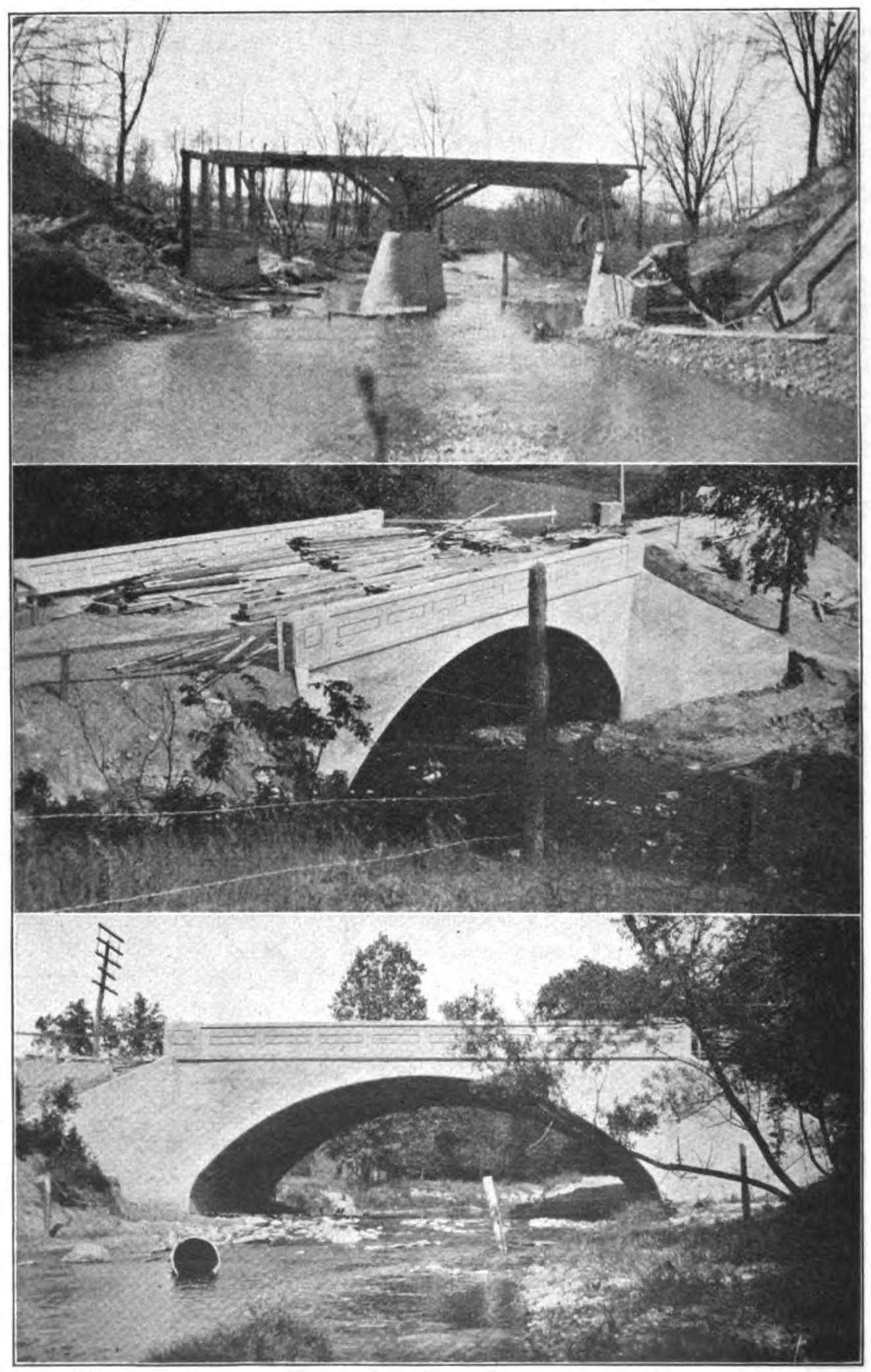
The Wyoming Bridge is a medium-span arch bridge in the city of Wyoming. It carries M-21 BR over Plaster Creek in an industrialized area adjacent to Roosevelt Park. The bridge is a 60-foot, filled spandrel arch, with earth fill and an asphalt-surfaced roadway that is flanked on both sides by concrete sidewalks. The elliptically shaped arch springs from massive concrete abutments. It features a tapered arch ring, which is cast integrally with the plain-faced concrete spandrel walls. The guardrails are solid concrete, with recessed rectangular panels; bronze "Trunk Line Bridge" plates are mounted one their inside walls. Although the neighborhood around the Wyoming Bridge has changed substantially since the bridge's construction in 1916, the bridge itself remains unaltered and in good physical condition. In 1916 the Michigan State Highway Department designed Trunk line Bridge No. 58 over Plaster Creek in the city of Wyoming. Located on the trunk line route that extended south of Grand Rapids, the Kent County seat, the structure featured a 60-foot, filled spandrel concrete arch. The agency hired Grand Rapids contractors Hilding and Rabe to build the bridge. Finished later that year, the structure's $13,146.55. Cost was borne almost equally by the state highway department, the Kent County Road Commission and the Grand Rapids Railway Company. For three years the railway company ran its inter-urban cars over the bridge, but in 1919 discontinued the line and removed its tracks. The Wyoming Bridge has since carried vehicular traffic in essentially unaltered condition. |
This bridge is tagged with the following special condition(s): Unorganized Photos
![]()
![]()
![]()
![]()
Coordinates (Latitude, Longitude):
Search For Additional Bridge Listings:
Bridgehunter.com: View listed bridges within 0.5 miles (0.8 kilometers) of this bridge.
Bridgehunter.com: View listed bridges within 10 miles (16 kilometers) of this bridge.
Additional Maps:
Google Streetview (If Available)
GeoHack (Additional Links and Coordinates)
Apple Maps (Via DuckDuckGo Search)
Apple Maps (Apple devices only)
Android: Open Location In Your Map or GPS App
Flickr Gallery (Find Nearby Photos)
Wikimedia Commons (Find Nearby Photos)
Directions Via Sygic For Android
Directions Via Sygic For iOS and Android Dolphin Browser
USGS National Map (United States Only)
Historical USGS Topo Maps (United States Only)
Historic Aerials (United States Only)
CalTopo Maps (United States Only)

© Copyright 2003-2024, HistoricBridges.org. All Rights Reserved. Disclaimer: HistoricBridges.org is a volunteer group of private citizens. HistoricBridges.org is NOT a government agency, does not represent or work with any governmental agencies, nor is it in any way associated with any government agency or any non-profit organization. While we strive for accuracy in our factual content, HistoricBridges.org offers no guarantee of accuracy. Information is provided "as is" without warranty of any kind, either expressed or implied. Information could include technical inaccuracies or errors of omission. Opinions and commentary are the opinions of the respective HistoricBridges.org member who made them and do not necessarily represent the views of anyone else, including any outside photographers whose images may appear on the page in which the commentary appears. HistoricBridges.org does not bear any responsibility for any consequences resulting from the use of this or any other HistoricBridges.org information. Owners and users of bridges have the responsibility of correctly following all applicable laws, rules, and regulations, regardless of any HistoricBridges.org information.
![]()
