

View Information About HSR Ratings
This is one of the most unusual and fascinating concrete arch bridges in Michigan a pre-1909 arch bridge composed of unreinforced concrete! It may date to before 1900 making it among the oldest concrete bridges in the country.
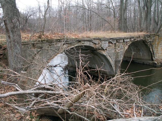
One look at the bridge and you can see that this bridge has been closed for eons! The western end of the bridge is right next to the new Cowling Road, and is easy to get to. One look at the eastern approach however reveals how long the bridge has been closed. With most abandoned bridges, you can usually see the old road grade and figure out where the road used to be, but that is not the case with this bridge! There are mature trees growing on the approach of the bridge and there is no sign of the old road. although some maps still show the old alignment of Cowling Road. Going back to the Cowling Road Bridge, the arches have deteriorated and weakened, resulting in the warping of the deck. Spalling is present on many parts of this concrete bridge. The bridge is attractive, partly due to a stamped stone design that was incorporated into the bridge. Although long ago somebody or something broke the railings off of the bridge, the remains of broken off steel pipes sunk into the concrete suggest that the original railing on the bridge was a pipe railing. The bridge itself is a two span structure.
Despite all the deterioration, no reinforcing rods are visible on the bridge. As the bridge has continued to deteriorate to extreme levels with no rebar exposed whatsoever, and following discovery of a 1909-dated postcard of the bridge proving this is an early concrete arch bridge, HistoricBridges.org strongly believes this is an unreinforced "mass concrete" type bridge, which is an exceedingly rare bridge type. Compare to this example in Ohio.
As of 2022, this bridge is amazingly still standing. The combination of record-breaking deterioration and lack of rebar make this bridge a testiment to the strength of concrete.

Above: Historical 1909 photo of bridge. The bridge does not look new in this photo based on the growth around the bridge. Thus, the bridge is assumed to be somewhat older than 1909, which is to be expected given the unreinforced design.

Above: Bridge in 2022. Photo Credit: Jason Holloway
This bridge is tagged with the following special condition(s): Unreinforced Concrete and Unorganized Photos
![]()
![]()
![]()
![]()
Coordinates (Latitude, Longitude):
Search For Additional Bridge Listings:
Bridgehunter.com: View listed bridges within 0.5 miles (0.8 kilometers) of this bridge.
Bridgehunter.com: View listed bridges within 10 miles (16 kilometers) of this bridge.
Additional Maps:
Google Streetview (If Available)
GeoHack (Additional Links and Coordinates)
Apple Maps (Via DuckDuckGo Search)
Apple Maps (Apple devices only)
Android: Open Location In Your Map or GPS App
Flickr Gallery (Find Nearby Photos)
Wikimedia Commons (Find Nearby Photos)
Directions Via Sygic For Android
Directions Via Sygic For iOS and Android Dolphin Browser
USGS National Map (United States Only)
Historical USGS Topo Maps (United States Only)
Historic Aerials (United States Only)
CalTopo Maps (United States Only)

© Copyright 2003-2025, HistoricBridges.org. All Rights Reserved. Disclaimer: HistoricBridges.org is a volunteer group of private citizens. HistoricBridges.org is NOT a government agency, does not represent or work with any governmental agencies, nor is it in any way associated with any government agency or any non-profit organization. While we strive for accuracy in our factual content, HistoricBridges.org offers no guarantee of accuracy. Information is provided "as is" without warranty of any kind, either expressed or implied. Information could include technical inaccuracies or errors of omission. Opinions and commentary are the opinions of the respective HistoricBridges.org member who made them and do not necessarily represent the views of anyone else, including any outside photographers whose images may appear on the page in which the commentary appears. HistoricBridges.org does not bear any responsibility for any consequences resulting from the use of this or any other HistoricBridges.org information. Owners and users of bridges have the responsibility of correctly following all applicable laws, rules, and regulations, regardless of any HistoricBridges.org information.
![]()